Port de Vent
This article is a work-in-progress because it is incomplete and pending further input from an author. Note: The contents of this article are not considered canonical and may be inaccurate. Please comment on this article's talk page to share your input, comments and questions. |
Trade Islands of Port de Vent | |
|---|---|
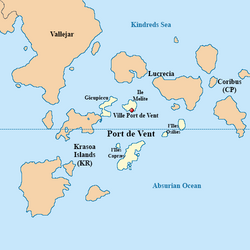
 Map of Port de Vent | |
| Nation | |
| Constituent Country equivalent | Burgoignesc Overseas Representative Assembly |
| Geographic Designation | Polar Burgundies |
| Capital | Ville Port de Vent |
| Area | |
| • Total | 62,366.9137 km2 (24,080.0000 sq mi) |
| Population (2030) | |
| • Total | 11,302,230 |
| • Density | 180/km2 (470/sq mi) |
| Demonym(s) | Ventoise |
Geography

Climate and environment

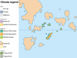
Port de Vent has a tropical wet and dry climate.
- {{wp|Geography_of_New_Caledonia#Climate} (reference)
Economy
Standard of living
Employment
Agriculture
Agrinergie
Main article: Agrivoltaics
Tourism and hospitality
Resorts
Cruises
Recreation
Key tourism and hospitality companies
Logging/Mineral extraction
Paper milling
Mining
Drilling
Fishing
Fishing and fisheries
Distant-water fishing fleet
Local commercial fishing
Aquaculture
Main article: Aquaculture Aquatic life farming, in general
- Pisciculture- fish farming
- Mariculture- Saltwater fish farming
- shrimp farming
- oyster farming
- algaculture
Artisanal/heritage industries
Science and research
Finance
Manufacturing
Industrial recycling
Creative industries
Sports and leisure
Trade
| Port Nova Martillia | |
|---|---|
 | |
| Location | |
| Country | |
| Details | |
| Opened | 1949 |
| Employees | 550 |
| Statistics | |
| Vessel arrivals | 179 |
| Annual cargo tonnage | 805.219 tonnes |
| Annual revenue | ₮25 million |
Transshipment
Main article: Transshipment
Customs and tariffs
Main article: Customs
