Albion Sea Gas Fields: Difference between revisions
Jump to navigation
Jump to search
mNo edit summary |
mNo edit summary |
||
| Line 1: | Line 1: | ||
Overview | Overview | ||
{{Infobox body of water | {{Infobox body of water | ||
| name = Albion Sea Gas Field | | name = Albion Sea Gas Field | ||
| Line 28: | Line 27: | ||
}} | }} | ||
[[Category:Arcerion]] | [[Category:Arcerion]] | ||
== History == | |||
== Development == | |||
=== Gas Field === | |||
=== Pipeline === | |||
=== Processing Plant === | |||
== | === Employment === | ||
== Production == | == Production == | ||
== Sovereignty == | == Sovereignty == | ||
Revision as of 14:54, 7 September 2022
Overview
| Albion Sea Gas Field | |
|---|---|
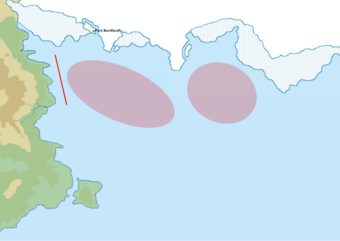
 Map of the Albion Sea Gas Field's Approximate Area, with Arcerion Exclusive Economic Zone marked with Red Line | |
| Type | Sea |
| Primary inflows | Odoneru Ocean, Arctic Shelf Runoff |
| Basin countries | Arcerion, Alpachnee, Kiravia |
| Average depth | 126 m (413 ft) |
| Max. depth | 843 m (2,766 ft) |
| Islands | New Moorden, Elizabeth, Gibson, Atrassica |
| Settlements | Port Northford |