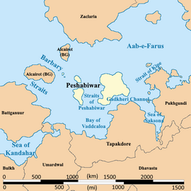
Peshabiwar colony
| This article is a stub. You can help IxWiki by expanding it. |
Confederated States of Peshabiwar | |
|---|---|
|
Flag | |
 Location of Peshabiwar | |
| Largest largest city | Gadkheri |
| Official languages | Peshbi, Burgoignesc |
| Ethnic groups | Peshabi, Template:Kashmiris |
| Religion | Sikhism, Hinduism, Jainism |
| Demonym(s) | Peshbi |
| Government | Republic |
| Establishment | |
• Independence | 1811 |
| Area | |
• Total | 682,047.469 km2 (263,340.000 sq mi) |
| Population | |
• 2028 estimate | 43,540,580 |
• Density | 63.838/km2 (165.3/sq mi) |
| GDP (nominal) | estimate |
• Total | $748,911,908,985.60 |
• Per capita | $17,200.32 |
| Currency | Common Middle Sea Florin (CMS ƒ) |
| Driving side | right side |
Peshabiwar, officially the Confederated States of Peshabiwar, is an industrializing nation in the western Audonian region of Daria. It is bordered by the Aab-e-Farus to the north, the Sea of Saksona to the east, Tapakdore to the southeast, Dhavastu to the south, and Umardwal to the west. It also shares maritime borders with the Burgoignesc islands of Alcairet and Salarive.
Peshabiwar has a unicameral legislature, a supreme court, and an executive, the President. The supreme court is recognized as having the most power in the country.
It is a member of the League of Nations, the International Red Cross and Red Crescent Movement, and many other international organizations.
It is am emerging market, market economy focused on exports, under the watchful eye of Burgundie whose companies have a massive stake in the country's economic activity. It is an active leader in the Middle seas region's economic activity.
Many scholars have criticized its economic governance and politics, arguing that it is merely a client of the Burgoignesc thalattocracy's economic and cultural might.
The people of Peshabiwar are predominantly culturally Peshabi or Template:Kashmiris, speak Peshbi, and most practice Sikhism, Hinduism, or Jainism.
Climate
Economy
Infrastructure
Roads and rail
Louage
A louage is a minibus shared taxi in many parts of Daria that were colonized by Burgundie. In Burgoignesc, the name means "rental." Departing only when filled with passengers not at specific times, they can be hired at stations. Louage ply set routes, and fares are set by the government. In contrast to other share taxis in Audonia, louage are sparsely decorated. Louages use a color-coding system to show customers what type of transport they provide and the destination of the vehicle. Louages with red lettering travel from one state to another, blue travel from city to city within a state, and yellow serves rural locales. Fares are purchased from ticket agents who walk throughout the louage stations or stands. Typical vehicles include: the MILCAR Jornalero, the TerreRaubeuer Valliant 130, and the CTC M237-07.


