Roads in Cartadania
This article is a work-in-progress because it is incomplete and pending further input from an author. Note: The contents of this article are not considered canonical and may be inaccurate. Please comment on this article's talk page to share your input, comments and questions. |
History
Roads by management authority
Federal estrada and interestadual
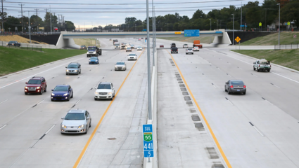
The federal highway system is split into two types of highway–estrada and interestadual, both managed by the Cartadania Department of Transportation (CDOT). The distinction between the two kinds of federal high capacity roads is mainly a historical one, though with some very explicit reasoning for their distinction. Outside of urban areas, those differences seldom have practical consequences, though both types may still exist in rural areas. Both kinds are divided highways with full access control and at least two lanes per direction of travel. General speed limits for both are established by the Uniform Traffic Code as 60–140 kilometers per hour (37–87 mph), though specific limits may be imposed based on road, meteorologic, or traffic conditions,
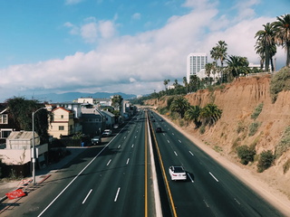
Interestaduais (lit. 'interstates') are specifically reserved for automobile traffic, thus any vehicles unable to sustain at least 60 kilometers per hour (37 mph) are prohibited from travel on them. Interstates have strict guidelines they must follow, especially at state borders. According to the Uniform Traffic Code, no government, contracted corporation, or other organization may implement tolling on all travel lanes of an interstate, thus, many jurisdictions will impose express lane tolling, incentivized by higher speeds and separation from the general purpose lanes (which must remain free). These are extremely commonplace in major urban areas, where traffic congestion can be nightmarish. Though the numbering scheme for interstate highways is usually even counting up from south to north (for east-west running interstates) and odd counting west to east (for north-south running interstates), there are some irregularities in the system. For example, Interstate Highway 21 begins in northwest Espírito Santo at a fork with Interstate Highway 15. It forms a U-shape around the perimeter of the Carina Bay before heading northeast to north central Victoria where it terminates east of Interstate 33. Another example is Interstate Highway 68, the longest highway in Cartadania and the northern perimter highway running parallel to the Odoneru coastline. IH-68 travels in its normal order in the Lusia region, but when heading west as the highway turns southwest, it dips below IH-50, IH-48, and IH-44, with which it has interchanges before heading almost due south and terminating at the Bahia coast. Heading west across the Aluna and Marée Channels, IH-68 continues to trace its path against the coastline. On Urlazio, however, IH-70, IH-80, and IH-84 are all completely south of IH-68. These irregularities have to do with extensions of existing interstates to their modern or future terminii and CDOT's avoidance of renumbering existing highways, though this is speculated to change in the future.
In contrast, estradas (lit. 'roads', though usually only used to refer to federal highways) allow slower vehicles like bicycles, scooters, and agricultural machinery. They are permitted under certain restrictions so as to not disrupt the traffic excessively or cause any danger. Furthermore, an estrada can be a newly constructed highway or an upgrade to an existing road, in which case it will most likely follow the original road very closely, only deviating from it to bypass certain populated areas. Estradas may also have direct access zoning in some areas and can even have bus stops. The speeds for most estradas, though permitted to be as high as an interstate, are usually not in excess of 100 kilometers per hour (62 mph), and are usually considerably lower in zoned areas. In essence, they function as major arterials instead of true highways.
-
IH-55 South passing through southwest Rieti County, Alexandria before entering Verona, circumnavigating Alahuela
-
IH-20 overlap with State Route 80 in Ariza, Vitrea.
-
Cartadania Federal Highway 175 showing direct access driveways
State roads
State highways are generally a mixture of primary and secondary roads, although some are freeways. Each state has its own system for numbering and its own marker. The default marker is a white, slightly rounded rectangle containing a black sans serif number (often outlined in black), according to the Uniform Traffic Code. However each state is free to choose a different marker, and nearly every state has (the exception being Lipora). States may choose a design theme relevant to its state (such as an outline of the state itself) to distinguish state route markers from interstate, county/parish, or municipal route markers. State departments of transportation are responsible for the upkeep of roads within their jurisdiction that do no explicitly belong to the municipalities or county-level jurisdictions (although the state may assume control of any road within its borders).
Verona and Santiago have the most highway mileage overall, with 116,436 kilometres (72,350 mi) and 111,708 kilometres (69,412 mi), respectively, oweing to their immense populations. In both states, all roads except those owned by municipalities are the responsibility of the state DOT. In São Andreas, the state provides oversight and guidelines for roadway construction, but the responsibility falls on the counties. Miraflores, the smallest state, unironically has the smallest state highway system, at just over 26,436 kilometres (16,427 mi).
-
Verona State Highway Beltway 40 intersection with the Palm Coast Grand Parkway in Buenaventura. BW40 is undergoing expansion to ten lanes.
-
The Pascal Escoffier Bridge in Maresia, carrying CH-9 between Saint James and Marin Parishes, during construction.
-
Alta Roma SR-440, a state road that is not highway-form.
Municipal roads
Municipal roads in Cartadania most commonly refer to city streets and county roads, although in some states, they may also refer to roads owned and maintained by metropolitan transit authorities or similar organizations. They follow traditional road hierarchy, usually inclusive of arterials, collectors, and local roads, but excluding freeways (managed by federal and state authorities). Some states may assume control over major arterials if a municipality is not able to alleviate strain on the system, in which case, some states may redesignate the road as a state highway. Each states guidelines and budget have a major impact on the municipalities' rights and abilities to extend their own systems, thus states with higher DOT budgets tend to have higher quality infrastructure.
Notable roads and statistics
Quality and safety

Road construction in Cartadania has heavily evolved over the years, from its traditional dirt roads to the smart superstructures of today's urban centers, greatly improving the quality of the roadway. In large part, the materials still consist of either aggregate/asphalt or concrete/cement. A major change in road construction began in 2009, when the Departments of Transportation of Alexandria and Triessa began recycling glass and plastics into the construction of their roadways. This method takes waste glass, pulverizes it into a sand-like texture, and incorporates it into pavement as a replacement for aggregate, while waste plastics are pulverized into slightly larger pellets and used as a binder. This reduces the amount of glass and plastic in landfills, while simultaneously reusing the products and further strengthening the roadway itself, further reducing the amount of milling and repaving needed to upkeep the surface.
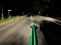
A particularly new addition to Cartadania's roadways is the use of photoluminescent paints in roadway markings. These paints absorb light during the day, storing the energy, then glow at night as the energy depletes. Markings with this paint were shown to improve highway visibility greatly at night, especially in areas that were dimly lit or lacked lighting altogether, reducing roadway visibility-related accidents by about 40% according to the Federal DOTs Safety Office. The paints used will typically hold their glow for about 8-10 hours per day, leaving just over an hour of standard visibility for the remainder of the night. They will also glow in times of lowlight daytime conditions (e.g., thunderstorms, heavily overcast days, etc.) and even in some cases of flooding, thus the usage has been deemed a simple necessity, and thus all roadways will eventually convert to using this marking style.

All states in Cartadania use smart roadways in some form or another. This generally includes magnetized sensors under the road surface to synchronize traffic signals, traffic measurement systems to adjust signalization length or system demand, real-time statistics for commute planning and closures, and many other techniques to help alleviate strain on the nation's roadways. Interstate highways around the National Metro, as well as throughout the surrounding states, have localized traffic monitoring. Controversial due to its upfront cost, the system allows local and state DOT agents, law enforcement, and EMS to see a virtual environment of the highway network and where all vehicles are located, including stopped cars, accidents, and other incidents.


