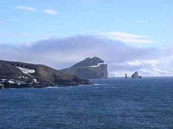
Freda Island
 Entrance to Freda Island | |
| Geography | |
|---|---|
| Location | Australis |
| Area | 72 km2 (28 sq mi) |
| Length | 12 km (7.5 mi) |
| Width | 12 km (7.5 mi) |
| Highest elevation | 542 m (1,778 ft) |
| Highest point | Mount Charco |
| Administration | |
| Demographics | |
| Population | 60 |
Freda Island is an island in the Okatian Sea close to the Australis Peninsula with a large and safe natural harbor. This island is the caldera of an active volcano, which seriously damaged local scientific stations in 1967 and 1969. The island previously held a whaling station; it is now a popular tourist destination with over 15,000 visitors per year with holding two scientific stations from Pelaxia and a small naval base. While various countries have asserted sovereignty, it is still administered as a Pelaxian dependency.
History


Gabo de Pogiano (1577 – c. 1620) was a Pelaxian explorer and navigator. A native of Rio Azul, it has been argued that he was an early explorer of Australis.
In March 1603, Pogiano was at the head of an expedition that weighed anchor from Albalitor. Under his control were three ships: the galleon Jesús María, of 600 tons and 30 cannons, Nuestra Señora de la Visitación and Nuestra Señora de las Mercedes. The expedition was entrusted by the King Alfonso II, Luis de Velasco, marqués de Salinas, to suppress the incursions of Caphirians privateers in the seas to the south of Takatta Loa.
Historians conjecture that they penetrated to a latitude of (64° S) in the Okatian Sea, and made port in the Freda Island. If correct, this would be the farthest south that anyone had travelled, at that time. Subsequently, several merchant vessels reported being blown south of 60° S in severe weather.