Zalgis: Difference between revisions
Hendalarsk (talk | contribs) mNo edit summary Tag: 2017 source edit |
Hendalarsk (talk | contribs) m (hyperlinking) Tag: 2017 source edit |
||
| Line 26: | Line 26: | ||
| subdivision_type2 = Provinces | | subdivision_type2 = Provinces | ||
| subdivision_name2 = | | subdivision_name2 = | ||
* Südgebiet | * [[South Province, Hendalarsk|Südgebiet]] | ||
* Haupstadtterritorium Hendalarskaras | * [[Hendalarskara Capital Territory|Haupstadtterritorium Hendalarskaras]] | ||
* Zentrum | * [[Centre Province, Hendalarsk|Zentrum]] | ||
* Zalgismund | * [[Mouth of the Zalgis|Zalgismund]] | ||
| subdivision_type3 = Cities | | subdivision_type3 = Cities | ||
| subdivision_name3 = | | subdivision_name3 = | ||
* Grenzdalar | * [[Grenzdalar]] | ||
* Jenverdorf | * [[Jenverdorf]] | ||
* Frehmenwerth | * [[Frehmenwerth]] | ||
* Agaren | * [[Agaren]] | ||
* Schullerhausen | * [[Schullerhausen]] | ||
* Rasenwald | * [[Rasenwald]] | ||
* Zalgisbeck | * [[Zalgisbeck]] | ||
| subdivision_type4 = | | subdivision_type4 = | ||
| subdivision_name4 = | | subdivision_name4 = | ||
| Line 51: | Line 51: | ||
| depth_avg = | | depth_avg = | ||
| depth_max = | | depth_max = | ||
| discharge1_location= Zalgisbeck | | discharge1_location= [[Zalgisbeck]] | ||
| discharge1_min = 2,785 m3 /s (98,400 cu ft/s) | | discharge1_min = 2,785 m3 /s (98,400 cu ft/s) | ||
| discharge1_avg = 4,063 m3 /s (143,500 cu ft/s) | | discharge1_avg = 4,063 m3 /s (143,500 cu ft/s) | ||
| discharge1_max = 6,281 m3 /s (221,800 cu ft/s) | | discharge1_max = 6,281 m3 /s (221,800 cu ft/s) | ||
<!---------------------- BASIN FEATURES --> | <!---------------------- BASIN FEATURES --> | ||
| source1 = Kaschwere, Südgebiet | | source1 = [[Kaschwere]], [[South Province, Hendalarsk|Südgebiet]] | ||
| source1_location = | | source1_location = | ||
| source1_coordinates= <!-- {{Coord|...}} --> | | source1_coordinates= <!-- {{Coord|...}} --> | ||
| source1_elevation = 2,583 m (8,474 ft) | | source1_elevation = 2,583 m (8,474 ft) | ||
| mouth = Zalgisbeck, Zalgismund | | mouth = [[Zalgisbeck]], [[Mouth of the Zalgis|Zalgismund]] | ||
| mouth_location = | | mouth_location = | ||
| mouth_coordinates = <!-- {{Coord|...|display=inline,title}} --> | | mouth_coordinates = <!-- {{Coord|...|display=inline,title}} --> | ||
| Line 74: | Line 74: | ||
| waterfalls = Teufelsmund | | waterfalls = Teufelsmund | ||
| bridges = | | bridges = | ||
| ports = Zalgisbeck | | ports = [[Zalgisbeck]] | ||
| custom_label = | | custom_label = | ||
| custom_data = | | custom_data = | ||
Revision as of 00:01, 14 May 2021
| Zalgis Sałgys (Lechian) | |
|---|---|
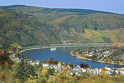
 The Zalgis southeast of Frehmenwerth | |
| Location | |
| Country | |
| Provinces | |
| Cities | |
| Physical characteristics | |
| Source | Kaschwere, Südgebiet |
| • elevation | 2,583 m (8,474 ft) |
| Mouth | Zalgisbeck, Zalgismund |
• elevation | 1m (3.3 ft) |
| Length | 1,623 km (1,008 mi) |
| Discharge | |
| • location | Zalgisbeck |
| • average | 4,063 m3 /s (143,500 cu ft/s) |
| • minimum | 2,785 m3 /s (98,400 cu ft/s) |
| • maximum | 6,281 m3 /s (221,800 cu ft/s) |
| Basin features | |
| Population | 28,000,000 (2018 est.) |
| Waterfalls | Teufelsmund |
| Inland ports | Zalgisbeck |
The Zalgis (Lechian: Sałgys) is the longest river located wholly in Hendalarsk, one of the country's Five Great Waterways. Also known as the Mother of the Waters (Wässermutter) due to its longstanding religious, cultural and economic significance, it has played a crucial role in the country's history and development and remains its major commercial artery to the present day. Around a third of the country's population live within the river's watershed, and Hendalarsk's three largest cities - Frehmenwerth, Schullerhausen and Zalgisbeck - all lie along its course.
Religious significance
The river's name derives directly from the Proto-Gothic '*albī' ("river") via the Old Hendalarskara "Salgi"; this older pronunciation survives in the Lechian name for the river to this day. The Zalgis was worshipped in many old Hendalarskara cults, both directly and in the abstract, as Salgi the Mother, a goddess of fertility; shrines, embankment temples and sacred groves dedicated to her have been attested along much of the river's length, dating to long before its political consolidation. This significance has, after a fashion, persisted into the Christian era in Hendalarsk; the majority of the nation's baptisms take place along the banks of the river, and although disposal of human remains in the river is a serious criminal offence, an exemption exists for ash cremated to industry standards, and tens of thousands of people have their ashes scattered along its banks annually.