File:Genova, A Lanterna.jpg
Jump to navigation
Jump to search

Size of this preview: 398 × 599 pixels. Other resolutions: 159 × 240 pixels | 319 × 480 pixels | 510 × 768 pixels | 680 × 1,024 pixels | 1,360 × 2,048 pixels | 2,848 × 4,288 pixels.
Original file (2,848 × 4,288 pixels, file size: 7.2 MB, MIME type: image/jpeg)
Summary
| Description |
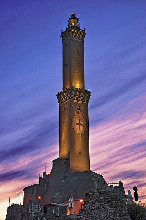
Italiano: Lanterna di Genova ,simbolo della città di Genova, sita sul promontorio di Capo di Faro la Lanterna, con i suoi 77 metri di altezza, è il faro più alto del Mediterraneo.L’attuale costruzione risale al 1543, ma fin dal XII secolo esisteva una torre di struttura simile, nata come torre di guardia per annunciare l’arrivo di imbarcazioni sospette e divenuta nel tempo anche faro, sulla cui sommità si bruciavano fascine per segnalare ai naviganti l’accesso al porto.
|
||
| Date | Taken on 3 February 2011, 17:52:19 | ||
| Source | Own work | ||
| Author | Carlo grifone |
| Camera location | | View this and other nearby images on: OpenStreetMap |
|---|
Licensing
I, the copyright holder of this work, hereby publish it under the following license:
This file is licensed under the Creative Commons Attribution-Share Alike 4.0 International license.
- You are free:
- to share – to copy, distribute and transmit the work
- to remix – to adapt the work
- Under the following conditions:
- attribution – You must give appropriate credit, provide a link to the license, and indicate if changes were made. You may do so in any reasonable manner, but not in any way that suggests the licensor endorses you or your use.
- share alike – If you remix, transform, or build upon the material, you must distribute your contributions under the same or compatible license as the original.

|
This image was uploaded as part of Wiki Loves Monuments 2018.
|
 |
File history
Click on a date/time to view the file as it appeared at that time.
| Date/Time | Thumbnail | Dimensions | User | Comment | |
|---|---|---|---|---|---|
| current | 17:50, 8 September 2018 | | 2,848 × 4,288 (7.2 MB) | wikimediacommons>Carlo grifone | User created page with UploadWizard |
File usage
The following page uses this file: