File:Wien - Neue Hofburg.JPG
Original file (5,050 × 2,220 pixels, file size: 7.4 MB, MIME type: image/jpeg)
This file is from Wikimedia Commons and may be used by other projects. The description on its file description page there is shown below.
Summary
DescriptionWien - Neue Hofburg.JPG |
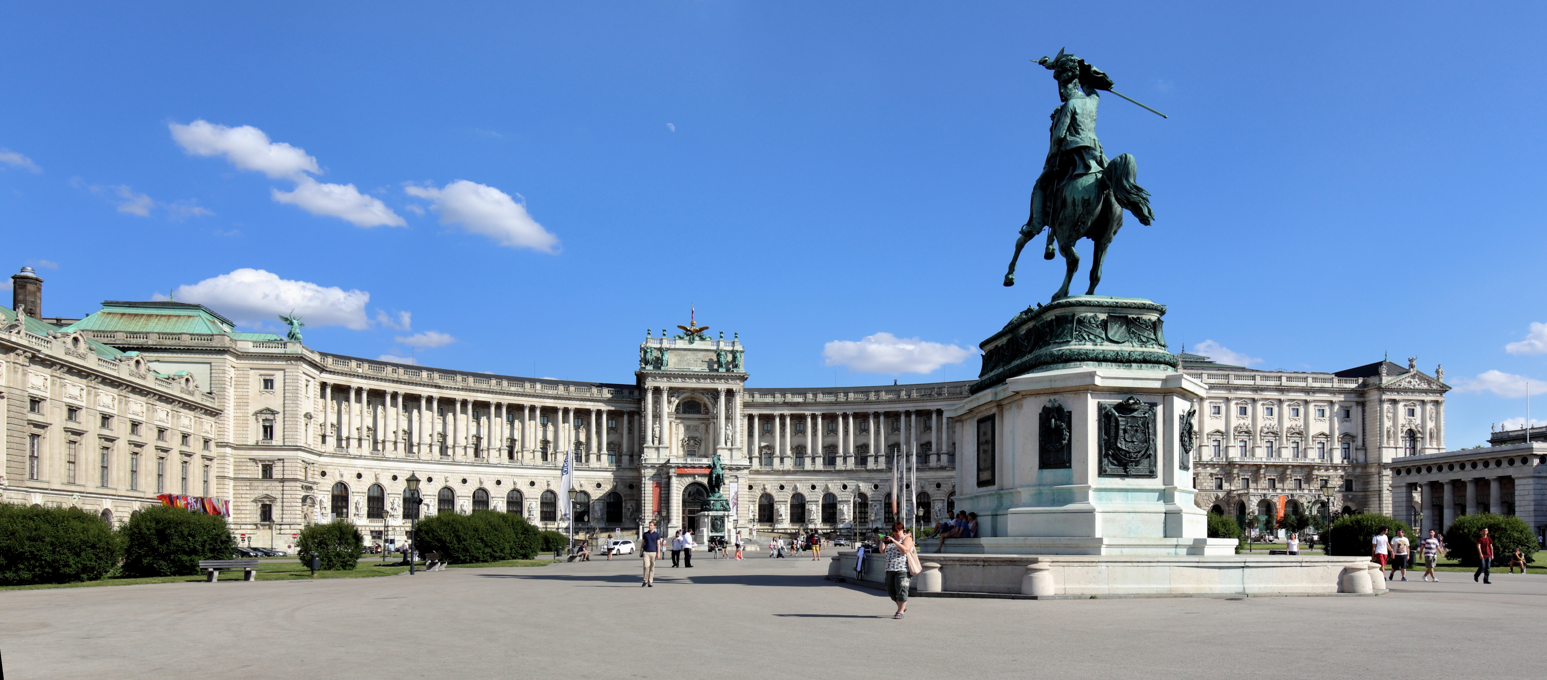
Deutsch: Die Hauptfassade der Neuen Burg in der österreichischen Bundeshauptstadt Wien.
Im Vordergrund der Heldenplatz mit dem Erzherzog-Karl-Reiterdenkmal, ganz links der Festsaaltrakt und ganz rechts das Äußere Burgtor. English: Neue Hofburg with Archduke Karl monument in Vienna.
|
|||
Date | ||||
Source | Own work | |||
Author | C.Stadler/Bwag | |||
Permission (Reusing this file) |
Deutsch: Hallo, du darfst mein Foto kostenlos nutzen, aber nenne mich bitte als Fotograf, beispielsweise „Foto: C.Stadler/Bwag“ oder © C.Stadler/Bwag; CC-BY-SA-4.0. Auf mehr Angaben bestehe ich nicht - im Gegensatz zu manch anderen, die die Vorgaben der unten angeführten Lizenzierung auf Punkt und Beistrich einfordern. English: Feel free to use my photos, but please mention me as the author like © C.Stadler/Bwag or © C.Stadler/Bwag; CC-BY-SA-4.0 (that's good enough) and if you want send me a message: [email protected]. |
Camera location | 48° 12′ 25.03″ N, 16° 21′ 47.36″ E | View this and other nearby images on: OpenStreetMap | 48.206953; 16.363155 |
---|
Licensing
- You are free:
- to share – to copy, distribute and transmit the work
- to remix – to adapt the work
- Under the following conditions:
- attribution – You must give appropriate credit, provide a link to the license, and indicate if changes were made. You may do so in any reasonable manner, but not in any way that suggests the licensor endorses you or your use.
- share alike – If you remix, transform, or build upon the material, you must distribute your contributions under the same or compatible license as the original.
This image was uploaded as part of Wiki Loves Monuments 2014.
Afrikaans ∙ Alemannisch ∙ azərbaycanca ∙ Bahasa Indonesia ∙ Bahasa Melayu ∙ Bikol Central ∙ bosanski ∙ brezhoneg ∙ català ∙ čeština ∙ Cymraeg ∙ dansk ∙ davvisámegiella ∙ Deutsch ∙ eesti ∙ English ∙ español ∙ Esperanto ∙ euskara ∙ français ∙ Frysk ∙ Gaeilge ∙ galego ∙ hrvatski ∙ Ido ∙ italiano ∙ latviešu ∙ Lëtzebuergesch ∙ Malagasy ∙ magyar ∙ Malti ∙ Nederlands ∙ norsk ∙ norsk nynorsk ∙ norsk bokmål ∙ polski ∙ português ∙ português do Brasil ∙ română ∙ shqip ∙ sicilianu ∙ slovenčina ∙ slovenščina ∙ suomi ∙ svenska ∙ Tagalog ∙ Türkçe ∙ Yorùbá ∙ Zazaki ∙ Ελληνικά ∙ беларуская ∙ беларуская (тарашкевіца) ∙ български ∙ кыргызча ∙ македонски ∙ русский ∙ српски / srpski ∙ українська ∙ ქართული ∙ հայերեն ∙ नेपाली ∙ हिन्दी ∙ বাংলা ∙ മലയാളം ∙ ไทย ∙ 한국어 ∙ +/− |
This image has been assessed using the Quality image guidelines and is considered a Quality image.
العربية ∙ جازايرية ∙ беларуская ∙ беларуская (тарашкевіца) ∙ български ∙ বাংলা ∙ català ∙ čeština ∙ Cymraeg ∙ Deutsch ∙ Schweizer Hochdeutsch ∙ Zazaki ∙ Ελληνικά ∙ English ∙ Esperanto ∙ español ∙ eesti ∙ euskara ∙ فارسی ∙ suomi ∙ français ∙ galego ∙ עברית ∙ हिन्दी ∙ hrvatski ∙ magyar ∙ հայերեն ∙ Bahasa Indonesia ∙ italiano ∙ 日本語 ∙ Jawa ∙ ქართული ∙ 한국어 ∙ kurdî ∙ Lëtzebuergesch ∙ lietuvių ∙ македонски ∙ മലയാളം ∙ मराठी ∙ Bahasa Melayu ∙ Nederlands ∙ Norfuk / Pitkern ∙ polski ∙ português ∙ português do Brasil ∙ rumantsch ∙ română ∙ русский ∙ sicilianu ∙ slovenčina ∙ slovenščina ∙ shqip ∙ српски / srpski ∙ svenska ∙ தமிழ் ∙ తెలుగు ∙ ไทย ∙ Tagalog ∙ Türkçe ∙ toki pona ∙ українська ∙ vèneto ∙ Tiếng Việt ∙ 中文 ∙ 中文(简体) ∙ 中文(繁體) ∙ +/− |
Annotations InfoField | This image is annotated: View the annotations at Commons |
Items portrayed in this file
depicts
some value
6 July 2014
48°12'25.031"N, 16°21'47.358"E
0.00625 second
11
22 millimetre
100
image/jpeg
File history
Click on a date/time to view the file as it appeared at that time.
Date/Time | Thumbnail | Dimensions | User | Comment | |
---|---|---|---|---|---|
current | 03:04, 12 August 2022 | 5,050 × 2,220 (7.4 MB) | wikimediacommons>Bwag | m |
File usage
The following 4 pages use this file:
Metadata
This file contains additional information, probably added from the digital camera or scanner used to create or digitize it.
If the file has been modified from its original state, some details may not fully reflect the modified file.
Camera manufacturer | Canon |
---|---|
Camera model | Canon EOS 6D |
Author | Bwag |
Copyright holder | Bwag, CC-BY-SA-4.0 |
Exposure time | 1/160 sec (0.00625) |
F Number | f/11 |
ISO speed rating | 100 |
Date and time of data generation | 16:20, 6 July 2014 |
Lens focal length | 22 mm |
Latitude | 48° 12′ 25.03″ N |
Longitude | 16° 21′ 47.36″ E |
Altitude | 178.6 meters above sea level |
Orientation | Normal |
Horizontal resolution | 300 dpi |
Vertical resolution | 300 dpi |
Software used | Digital Photo Professional |
File change date and time | 16:20, 6 July 2014 |
Y and C positioning | Centered |
Exposure Program | Shutter priority |
Exif version | 2.3 |
Date and time of digitizing | 16:20, 6 July 2014 |
Meaning of each component |
|
APEX shutter speed | 7.375 |
APEX aperture | 7 |
APEX exposure bias | 0.66666666666667 |
Metering mode | Center weighted average |
Flash | Flash did not fire, compulsory flash suppression |
DateTime subseconds | 42 |
DateTimeOriginal subseconds | 42 |
DateTimeDigitized subseconds | 42 |
Supported Flashpix version | 1 |
Color space | sRGB |
Custom image processing | Normal process |
Exposure mode | Auto bracket |
White balance | Auto white balance |
Scene capture type | Standard |
GPS time (atomic clock) | 15:12:19.697 |
Satellites used for measurement | 11 |
Receiver status | Measurement in progress |
Measurement mode | 3-dimensional measurement |
Measurement precision | Poor (6.4) |
Geodetic survey data used | WGS-84 |
GPS date | 6 July 2014 |
GPS tag version | 0.0.3.2 |
Rating (out of 5) | 0 |