Gassavelia: Difference between revisions
mNo edit summary |
|||
| Line 30: | Line 30: | ||
== Geography == | == Geography == | ||
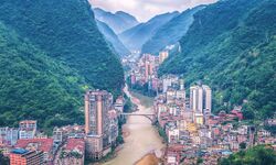
[[File:YanjinGassavelia.jpeg|thumb|250px|left|Many urban areas in Gassavelia sit in dramatic canyon-like areas.]] | |||
Most of Gassavelia sits in a valley between the [[Hortus Mountains]] to the west and the highlands of western [[Burgundie]] to the east, with the Harzenon River bisecting the country at the lowest point in the valley. The Harzenon River, which is thought to have formed the valley by erosion, is the primary site of human settlement within the state, and the Harzenon River basin makes up a majority of the land area of Gassavelia. Topographically, much of Gassavelia is uneven, with steep declines from the interior country to the rivers which cross the state forming deep canyons in many places. Most of Gassavelia is far above sea level. The significant topographical differences poses a challenge for the typically car-centric lifestyle of most Urceans, and consequently Gassavelians use automobiles less hours per year on average than any other area of [[Urcea]]. | Most of Gassavelia sits in a valley between the [[Hortus Mountains]] to the west and the highlands of western [[Burgundie]] to the east, with the Harzenon River bisecting the country at the lowest point in the valley. The Harzenon River, which is thought to have formed the valley by erosion, is the primary site of human settlement within the state, and the Harzenon River basin makes up a majority of the land area of Gassavelia. Topographically, much of Gassavelia is uneven, with steep declines from the interior country to the rivers which cross the state forming deep canyons in many places. Most of Gassavelia is far above sea level. The significant topographical differences poses a challenge for the typically car-centric lifestyle of most Urceans, and consequently Gassavelians use automobiles less hours per year on average than any other area of [[Urcea]]. | ||
Sitting just above the equator, Gassavelia is mostly covered in tropical rainforests and receives a significant amount of precipitation per year. | Sitting just above the equator, Gassavelia is mostly covered in tropical rainforests and receives a significant amount of precipitation per year. | ||
=== Cities and towns === | === Cities and towns === | ||
Revision as of 07:49, 1 October 2022
This article is a work-in-progress because it is incomplete and pending further input from an author. Note: The contents of this article are not considered canonical and may be inaccurate. Please comment on this article's talk page to share your input, comments and questions. |
Script error: The module returned a nil value. It is supposed to return an export table.
State of Gassavelia | |
|---|---|
| Country | Urcea |
| Cathedral City | Harzenon |
| Government | |
| • Secretary-General | Aron Mendick (S) |
| Population (2014) | |
| • Total | 89,204,152 |
The State of Gassavelia is one of two states of the Apostolic Kingdom of Urcea.
History
Geography

Most of Gassavelia sits in a valley between the Hortus Mountains to the west and the highlands of western Burgundie to the east, with the Harzenon River bisecting the country at the lowest point in the valley. The Harzenon River, which is thought to have formed the valley by erosion, is the primary site of human settlement within the state, and the Harzenon River basin makes up a majority of the land area of Gassavelia. Topographically, much of Gassavelia is uneven, with steep declines from the interior country to the rivers which cross the state forming deep canyons in many places. Most of Gassavelia is far above sea level. The significant topographical differences poses a challenge for the typically car-centric lifestyle of most Urceans, and consequently Gassavelians use automobiles less hours per year on average than any other area of Urcea.
Sitting just above the equator, Gassavelia is mostly covered in tropical rainforests and receives a significant amount of precipitation per year.
Cities and towns
Economy
Most of Gassavelia's traditional industries were centered around fishing. Most of the state is not suitable for agricultural development - the Kingdom of Gassavelia's historic agricultural region lay east in Faramount - and accordingly until recent times fishing was the primary source of food for the state. Recent technological innovations have made agricultural endeavors more successful, and farming is a rising industry in Gassavelia. In the 19th and 20th centuries, the state rapidly industrialized and made use of torrential rivers and streams for hydro-power.
