Istrenya: Difference between revisions
| Line 67: | Line 67: | ||
==Etymology== | ==Etymology== | ||
==Geography== | ==Geography== | ||
<gallery mode="packed"> | |||
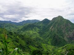
File:Southern Mountains.jpg|The Southern Mountain Range of Istrenya. | |||
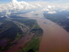
File:Eastern River Basin.PNG|The Eastern River Basin of Istrenya, which opens into the city of Karaba. | |||
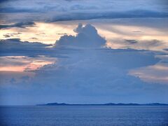
File:Malentinian_Channel.jpg|The Malentinian Channel the separates Istrenyan from Malentina. | |||
File:placeholder|Iraso Township in Western Istrenya. | |||
File:placeholder|Istrenyan Highlands. | |||
File:placeholder|Karaba Bay. | |||
</gallery> | |||
South Mountains | South Mountains | ||
Revision as of 14:39, 29 January 2023
Your Country Official Name ("Republic of XXX") Your Country in Another Language (Your language) | |
|---|---|
|
Flag | |
Motto: From Mountains to the Shores" | |
 Location of XXX (dark green) In XXX (gray) | |
| Capital | Karaba |
| Largest city | "capital" |
| Demonym(s) | Istrenyan |
| Government | Democratic Republic |
• President | M'Kole Tysh'le |
• Vice President | L'tore Yaruba |
| National Congress | |
| Population | |
• Estimate | ~32,000,000 |
| GDP (nominal) | estimate |
• Total | Your GDP = GDPPC x Population (This is calculated for you after first entry) |
• Per capita | Your GDP PC |
| Currency | Your Currency |
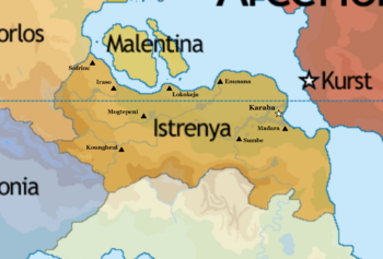
Istrenya, officially the Republic of Istrenya, is a country in Crona. It is neighbored by Arcerion across the Warrington Strait. By area is is one of the largest Indigenous countries in South Crona, and one of the most populous. With a population of 32 million, it also is the largest Southern Cronan Indigenous country that was not nominally aligned with Varshan. The national capital is the city of Karaba, which is also the nation's economic centre and the largest non-Occidental port in the Malentine Sea, largely due to trade from across the Warrington Strait coming from Arcerion. The country is bordered by Porlos, Malentina, and Ceylonia.
Seated at the foothills and lowlands North of the South Istrenyan Mountain Range, Istrenya was largely comprised of disparate river and mountain tribes as far back as 50,000 years ago. Closer to the modern and industrial era, Occidental colonists and traders established trading posts across the Warrington Strait, which eventually became the basis in the late 1700s and early 1800s for the city of Karaba. The following century saw an expansion of trading to the nearby towns of Madara and Sumbe, in the Eastern River Basin, where the majority of the nation's economic and industrial centres remain to this day.
Istrenya was never officially colonized or controlled by foreign powers, unlike many of its neighbours, owing to its poor geographic location and the favourable conditions in the Eastern Malentine where Ardmore and other Occidental countries were investing in the rapidly expanding Arcerion. Istrenya's independence was threatened during the 1956 Istrenyan Crisis where communist and socialist rebels attempted to overthrow the nation, and Arcer intervention prevented the Populist national government from being toppled and replaced by left-wing red factions based out of the Western half of Istrenya. The lasting effects of the Civil War are felt today, with the nation ethnically split between Eastern and Western cultural and tribal lines, the Eastern half regularly trades and entreats with Arcerion, whereas the West continually sees Arcerion as meddling in Indigenous affairs and violating the nation's sovereignty.
Istrenya is not particularly rich in natural resources or agriculture, mostly having a small fishing trade and some mining for raw materials in the Southern Mountains. Karaba's port is the most important Western Indigenous maritime port, servicing much of the country's needs. The next two largest cities, Madara and Mogtepeni both have disparate industries, the former being agrarian owing to its location in the Eastern River Basin, and the latter being a mining town mostly controlled by private Arcer corporations.
Istrenya's largest export is raw materials and raw minerals, over half of which are imported into Arcerion for refining and sold as finished goods. The human development of Istrenya has remained historically low throughout the 20th and 21st centuries, especially in the Western half of the nation. Istrenya has also been host to a large number of Varshani refugees after the Final War of the Deluge.
Etymology
Geography
-
The Southern Mountain Range of Istrenya.
-
The Eastern River Basin of Istrenya, which opens into the city of Karaba.
-
The Malentinian Channel the separates Istrenyan from Malentina.
-
Iraso Township in Western Istrenya.
-
Istrenyan Highlands.
-
Karaba Bay.
South Mountains
Eastern River Basin
Cities
Channels between Istrenya & Malentina
Highlands
Bay next to Karaba
History
Indigenous Tribes Period
Arrival of Traders
Lack of Colonizing
Early Modern
Istrenyan Civil War
Late Modern
Government
Executive
Presidential Office
Legislature
National Congress
Local governance
Tribal governments and townships
Culture
Cuisine
Eastern and Western Tribes
Demographics
Linguistic Demographics
Religious Demographics
Economy
Its bad
Like real bad
Military
Slow reparation since Civil War
Corruption
Lack of a real air force
small navy mostly cutters and small patrol craft


