Mount Koiski
| Mount Koiski | |
|---|---|
| Highest point | |
| Elevation | 6,085m |
| Prominence | 1,143m |
| Naming | |
| Etymology | Traditional Norse religious texts and sayings, ancient Cordish. |
| English translation | "Chief of the Gods" |
| Pronunciation | English pronunciation: /kɪ́jɔsgi/ |
| Geography | |
| Location | Olmeria |
| Parent range | li Mätvhas |
| Climbing | |
| First ascent | Never |
| Easiest route | Unknown |
Mount Koiski is a mountain in the li Mätvhas range, in central Olmeria. Its peak is more than 6,000m (19,685ft) above sea level, making it the tallest mountain in Olmeria and amongst the biggest in Ultmar. While the lower regions of the mountain's foothills are a popular tourist site, few venture up the mountain in earnest. In fact, no-one has yet summited the peak, although 608 people have officially tried, with 54 of them dying in the attempt. While the mountain is not in the ranks of the worlds tallest, with it's 6,085m (19,964ft) summit well below the so called death zone, long and exposed climbing routes, avalanche risks, extreme cold, altitude sickness and the sheer extent of the climb from base camp at only 2,306m (7,566ft) make it extremely deadly. Particularly, because base camp is so low and the climb so long, it becomes much harder to acclimatise to higher altitudes and minimise altitude sickness.
Name
Etymology
The name Koiski comes from the ancient Cordish word "Koisk", literally "the chief", "the leader". Koiski was the name of the primary god in most ancient Olmerian religions, recognised in traditional texts as chief of both the gods and the people. It particularly recognised the nature of Koiski as above any human chieftains the religious populace may have had, with the regular word for chieftain of a tribe being "höva", and the great chieftains of 500AD-1000AD known as "höva storstes" . Koiski therefore, meant chief of all, or chief of the world, separating the god from earthly leadership figures.
Mt Koiski itself has been known as such since its formal discovery around the 13th century, although its possible the mountain was discovered, and other names originated much earlier than this without proof in existing written records discovered by historians, and were then overtaken by the usage of Koiski. It believed to have been named by a Nordic monk by the name of Ukko on a pilgrimage, who had gotten lost and ventured further into the mountains than anyone had previously. Upon catching sight of Mt. Koiski's peak, he reportedly fainted in disbelief of its magnitude, and upon returned declared that the mountain must be a symbol of Koiski on earth. Religious groups who later travelled to see the mountain gradually began to call it this, and the site soon became a place of holy significance, accelerating the spread of the new name. In fact, Ukko himself was later recognised as a Kotka (equivalent of a saint) in many traditional Nordic religions, and is worshipped as such to this day.
| “ | I have seen what before I would not have believed. Such divine beauty, such might, and such inspiration that came upon me. It is, with no doubt, Koiski on earth, come to watch so that he might learn of our ways and watch our wrongs | ” |
| — Ukko (Nordic Monk) (c.1283) Chronicles of Kotka Ukko (English translation) Chapter 3: Gods in Beauty |
Misnomers
Mount Koiski (pronounced Koy-ski) is often referred to (incorrectly) as Mt. Kioski (pronounced Kiosk-ee), particularly by Levantine foreigners, with the pronunciation of Koiski unfamiliar to most occidental languages. Even native, city-living Olmerians can be caught slipping up, with the tonality of modern Cordish substantially different from that of the ancient language. This misnomer has been the subject of widespread memeing on the internet, after ai generated images of Kiosks at the summit of the mountain went viral in 2028. In fact, a sizeable internet movement, known to members as the Kioski Heritage Society (KHS) began campaigning for the mountain to be officially renamed Kioski in honour of the viral meme. When asked why they were so passionate about this, the leader of the KHS (known on social media platforms as @kioski_warrior_06) claimed it would be "for the laughs'' and that "no-one cares about that crappy old ancient name anyway". Although the movement gained significant fame and popularity online, the name of the mountain was unaffected and the Olmerian Department for Environmental Affairs confirmed no size of internet movement would convince them to change the name.
Locals in the rural Mätvhas region are particularly proud of the mountain's original name and history, and can be seen strongly correcting tourists who use the wrong name. Some particularly dedicated locals also set up the Koiski Defence League (KDL) in an attempt to counter the online success of the KHS, although it never garnered the same traction. The memes also attracted some anger from more traditional Nordic religious believers who saw it as a mockery of their primary god.
Controversy
For many centuries there has been religious controversies over the name of Mt Koiski. Some sects of traditionalist Nordic religions believe that naming a physical object, however grand or powerful, after Koiski is heretical and blasphemous. Extreme wings of prominent monotheistic religions, including Protestantism, Catholicism and Islam also refuse to recognise the mountain's name because of its roots in polytheistic religious beliefs, which they say contradicts core teachings of their respective religions. Some strong atheists also argue that the name isn't inclusive and is too politically charged, detracting from the international reputation of the mountain. However evidence suggests that the mountain’s religious history actually boosts its status as a major tourist attraction, with Nordic believers and those intrigued by the ancient beliefs making the trip to visit it.
Climbing
Permits

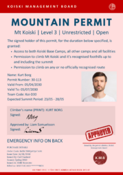
In 2008, the regional Mätvhas council introduced mandatory permits for anyone making a summit attempt on Mt Koiski. This came after the 2006 Mt Koiski Disaster, when a group of unprepared amateur mountaineers attempted to climb the mountain, leading to 15 deaths and tens of thousands of Lund in evacuation and rescue costs. Climbers were now required to prove prior mountaineering experience and medical fitness in order to receive a permit to make a formal summit attempt. However further rescues and deaths of inexperienced climbers in the 2009 and 2010 seasons demonstrated that the permits had not gone far enough, with people legally climbing into dangerous regions without formally making a summit attempt. Before the 2011 climbing season, the Koiski Management Board, who were now in charge of organising tourism and climbing on the mountain, extended the reach of the permit to any climbs above 3,900m (12,795ft), or around camp 2. The board also introduced a permit fee of 500Ⱡ to raise funds for the proper management of the mountain. In 2020 this was further extended, with a three tier permit system introduced, each with a different cost and burden of proof depending on the level of permit. Climbers or tourists now required a permit for any access to Koiski base camp or above (on either side of the mountain). Permits also now acted as emergency cards, with team and medical details on their reverse. This has saved several people when losing or forgetting standard emergency cards. Climbers must have a permit on them at all times on the mountain, although exception can be made in cases of an emergency explaining the loss of permit. No major changes have been made to the permit system since 2020.
Modern permits are divided into three levels, which are further subdivided by the side of the mountain and range of access. Climbers can choose a restricted permit, where they must stick to a set of designated standard routes, or unrestricted permits which give them unlimited access on the mountain up to the maximum altitude. Level 3 permits are all unrestricted as no route to the summit yet exists
| Permit Level | Side | Maximum Altitude/Camp | Range | Required Evidence | Cost |
|---|---|---|---|---|---|
| Level 1 | North | 3,000m | Unrestricted | - Basic fitness assessment
AND - Proof of off-piste mountaineering experience above 2,500m OR - OMC Basic Mountaineering Certificate, with off-piste module (or equivalent) |
150Ⱡ |
| Restricted | - None | 75Ⱡ | |||
| South | Unrestricted | ||||
| Restricted | |||||
| Level 2 | North | 3,908m (12,795ft) - Camp 2 | Unrestricted | - Proof of off-piste Mountaineering experience above 3,000m
- Moderate fitness assessment - OMC Intermediate Mountaineering Certificate, with off-piste module (oe) |
500Ⱡ |
| Restricted | - Basic fitness assessment
AND - OMC Intermediate Mountaineering Certificate (oe) OR - A minimum of 2 official guides and an OMC Basic Mountaineering Certificate (oe) |
325Ⱡ | |||
| South | Unrestricted | ||||
| Restricted | |||||
| Level 3 | North | None | Unrestricted | - OMC Advanced Mountaineering Certificate
- Comprehensive fitness and medical assessments - Fully comprehensive expedition plans and details |
1,200Ⱡ |
| South | |||||
| Open | 1,500Ⱡ |
Routes and Camps
North Side

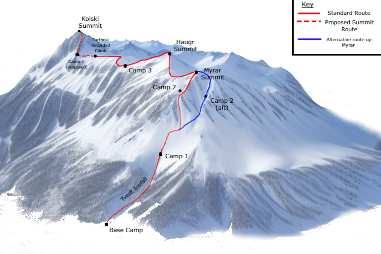
The north side of Mt Koiski hosts the so-called standard route, where the majority of summit attempts begin, in addition to the primary location for shorter climbs into the mountain's foothills. Climbers begin at Base Camp, 2,305m above sea level, which can be reached in around 8-10 days of hiking from the closest major settlement Härnösun. Härnösun itself hosts a small airport, providing flights to and from the rest of Olmeria, in addition to a substantial mountaineering sector. Local guides can be hired from here to assist in transporting equipment to base camp, or leading smaller expeditions. These guides have also participated in all but one summit attempt to date, although this is usually arranged prior to a teams arrival in Härnösun. It is also possible to charter a helicopter for people or equipment from Härnösun to Base Camp, an option utilised by wealthy tourists and rescue services in the case of disasters. However most serious summit attempts have begun with the hike to Base Camp to allow for basic acclimatisation and prepare the body for the climb to come.
Teams traditionally spend around 4-5 weeks based at base camp, making short expeditions up the mountain for acclimatisation and familiarisation with the route. Once aptly acclimatised at the lower altitudes of the mountain, teams complete the full day trek up across the Tvedt Icefall and through 950m of elevation to the official camp 1. Completing this in a day is in itself challenging, and several teams have attempted to split the leg by camping for a night at the top of the icefall (around 500m above base camp). From here, teams will spend a further 2 weeks recovering and continuing to acclimatise, making short day hikes further up the mountain.