Zalgis
The Zalgis (Khunyer: Szálkís) is the longest river located wholly in Hendalarsk, one of the country's Five Great Waterways, and one of the major rivers of Ultmar. Also known as the Mother of the Waters (Wäsermuter) due to its longstanding religious, cultural and economic significance, it has played a crucial role in the country's history and development and remains its major commercial artery to the present day. Around a third of the country's population (some 28 million people) live within the river's watershed, and three of Hendalarsk's five largest cities - Frémenwerd, Schulahaun and Zalgisbeck, where the river drains into the Vandarch - all lie along its 1,600-kilometre course.
| Zalgis Szálkís (Khunyer) | |
|---|---|
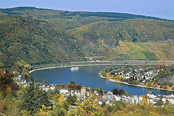
 The Zalgis southeast of Frémenwerd | |
| Location | |
| Country | |
| Provinces | |
| Physical characteristics | |
| Source | Kaschwere, Südgebiet |
| • elevation | 2,583 m (8,474 ft) |
| Mouth | Zalgisbeck, Zalgismund |
• elevation | 1m (3.3 ft) |
| Length | 1,623 km (1,008 mi) |
| Discharge | |
| • location | Zalgisbeck |
| • average | 4,063 m3 /s (143,500 cu ft/s) |
| • minimum | 2,785 m3 /s (98,400 cu ft/s) |
| • maximum | 6,281 m3 /s (221,800 cu ft/s) |
| Basin features | |
| Population | 28,000,000 (2018 est.) |
| Waterfalls | Teufelsmund |
Course
Before the Zalgistal
The river's source, as with the Stederau and the Rödos, is located in the Central Gothic Massif, a 2,000-kilometre mountain range which forms the major geographical barrier between the Odoneru and the Vandarch. It rises from a small spring on the slopes of the Zalgisberg, around which the monastery of Kaschwere grew. The river remains a small stream of little consequence, winding its way out of the massif through multiple small waterfalls such as the Katsch, until it unites with the Wolewere and Felbe streams shortly before the Teufelsmund, the last and largest waterfall on the river's route northwards.
From here the growing river carves a deep gorge, the Stefansschlucht, through the foothills of the massif, until finally emerging into the high plains that characterise southern Hendalarsk. At this point it begins to be used for irrigation, although this use is extremely tightly controlled in order to preserve the river's flow downstream. From Ölerána the river is navigable until the Vandarch, although it is liable to freeze over in winter; only from Frémenwerd northwards is the river reliably ice-free all year round, with the exception of the occasional floe from its lower reaches.
Jenwerdorf to Agaren
Agaren to the Vandarch
Towns and cities en route
| Town | Population |
|---|---|
| Kaschwere | 579[1] |
| Bólenwíz | 3,277 |
| Ölerána | 189,355 |
| Grenzdalá | 212,569 |
| Adalsgád | 13,802 |
| Jenwerdorf | 1,048,361 |
| Frémenwerd | 2,583,455 |
| Agáren | 1,160,275 |
| Schulahaun | 1,985,467 |
| Rasenwald | 309,012 |
| Golendóf | 75,199 |
| Zalgisbeck | 3,578,223 |
History
Religious significance
The river's name derives directly from the Proto-Gothic '*albī' ("river") via the Old Hendalarskara "Salgi"; this older pronunciation survives in the Khunyer name for the river to this day. The Zalgis was worshipped in many old Hendalarskara cults, both directly and in the abstract, as Salgi the Mother, a goddess of fertility; shrines, embankment temples and sacred groves dedicated to her have been attested along much of the river's length, dating to long before its political consolidation. This significance has, after a fashion, persisted into the Christian era in Hendalarsk; the majority of the nation's baptisms take place along the banks of the river, and although disposal of human remains in the river is a serious criminal offence, an exemption exists for ash cremated to industry standards, and tens of thousands of people have their ashes scattered along its banks annually.
Notes
- ↑ 579 monks, while 1,843 people live in the nearby town of Kaschwere, which does not actually lie on the river itself.