Ciulaga: Difference between revisions
mNo edit summary |
m Text replacement - "Port St. Brendan" to "Ventotene" |
||
| Line 134: | Line 134: | ||
== Geography == | == Geography == | ||
[[File:Diamond_Rock_and_Morne_Larcher_bay.jpg|thumb|right|200px|Ciulaga's northern beaches typically have rocky formations.]] | [[File:Diamond_Rock_and_Morne_Larcher_bay.jpg|thumb|right|200px|Ciulaga's northern beaches typically have rocky formations.]] | ||
Ciulaga is located in the confluence of the Kindreds and Taínean Seas about {{convert|472|km|mi}} southwest of the coast of mainland Cartadania and about {{convert|879|km|mi}} southeast of the nearest sovereign country, [[Urcea]], via [[ | Ciulaga is located in the confluence of the Kindreds and Taínean Seas about {{convert|472|km|mi}} southwest of the coast of mainland Cartadania and about {{convert|879|km|mi}} southeast of the nearest sovereign country, [[Urcea]], via [[Ventotene]]. It is due west of [[Santa Elena]], about {{convert|229|km|mi}} from shore to shore. The total area of Ciulaga is {{convert|320.7|km2|sqmi}}, of which {{convert|11|km2|sqmi}} is water and the rest land. Ciulaga is the 2nd largest island in Taíno-Kindredian confluence (Aveiro's Aragón and Salvador islands are considered to be wholly within the Taínean Sea). It stretches {{convert|32|km|mi}} in length and {{convert|97|km|mi}} in width. The highest point is the volcano of Mount Gistaín at {{convert|1291|m|ft}} above sea level. There are numerous small islands, particularly off the east coast. Aside from the mountains of the center-west, Ciulaga is mostly flat, with rocky coasts to the north, irregular hills at the center, mangrove at the southwest, and white sand beaches sheltered by coral reefs along the southern shore, especially around Melero. This is where the main tourist resorts are found. | ||
=== Climate === | === Climate === | ||
Ciulaga has a {{wp|tropical climate}} tempered by maritime influences and the {{wp|Trade Winds}}. There are two seasons, the dry season called "Lent" from January to June, and the wet season called "winter", from July to December. | Ciulaga has a {{wp|tropical climate}} tempered by maritime influences and the {{wp|Trade Winds}}. There are two seasons, the dry season called "Lent" from January to June, and the wet season called "winter", from July to December. | ||
Latest revision as of 08:09, 12 April 2022
Script error: The module returned a nil value. It is supposed to return an export table.
Ciulaga
Syul'qa | |
|---|---|
| Territory of Ciulaga Teritorio de Ciulaga | |
| Nickname: The Sun Isle | |
| Motto: Libertas vincit | |
 | |
| Country | |
| Territory of Second Class | 1928 |
| Territory of First Class | 2011 |
| Statehood | By 2028 (Planned) |
| Capital | Melero |
| Government | |
| • Type | Devolved presidential constitutional dependency |
| • Governor | Jon Alférez (SDP) |
| Area | |
| • Total | 320.7 km2 (123.8 sq mi) |
| • Land | 309.7 km2 (119.6 sq mi) |
| • Water | 11.0 km2 (4.2 sq mi) |
| Dimensions | |
| • Length | 96.8 km (60.1 mi) |
| • Width | 32.1 km (19.9 mi) |
| Population (2020) | |
| • Total | 318,039 |
| • Density | 990/km2 (2,600/sq mi) |
| Demonym(s) | Ciumo/a Ciumas (Plural) |
| PEP Code | 89970-89979 |
| Area code | 482 |
| Website | Official Government Site Official Tourism Site |
Ciulaga, also known by its indigenous name Syul'qa, is a territory of Cartadania located at the confluence of the Kindreds and Taínean Seas. It's capital and largest city is Melero, with just under 100,000 inhabitants. The island has an arid climate that attracts visitors seeking warm, sunny weather all year round. Ciulaga is a popular snorkeling and scuba diving destination because of its multiple shore diving sites and easy access to the island's fringing reefs. The island's total land area is 320 square kilometres (120 sq mi); it is 97 kilometres (60 mi) wide from east to west, and on average about 32 kilometres (20 mi) long from north to south.
History
Early history

The ancient history of the island that is today Ciulaga is not very well known, much like some of the other Taínean cultures (like that of the Suyara Archipelago). Unlike other indigenous cultures of the occident which may have left behind archaeological and physical evidence of their societies, very few artifacts and little evidence remains of Ciulaga's indigenous population. Scarce archaeological findings and early Cartadanian accounts from the colonial era constitute much of what is known about them. Early Cartadanians did co-exist and even intermix with the indigenous, preserving their culture for many generations, although even this exists solely in biological heritage, as the society of these indigenous peoples collapsed not long after Caphiro-Cartadanian arrival.
The group that originally lived on the island were found to share a similar genetic background as with the northern Taíneans like those of Suyara and Equitorial Ostiecia, but may have been genetically divergent from those of nearby Santa Elena, which often begs the question of how the northern Taíneans were able to migrate so far south. Census records from 1700 reveal that approximately 51% of Cartadanians in Melero were married to Taíneans of Ciuma origin, irrespective of sex or gender, and some present-day Ciumas have Taínean ancestry.
Maribel's War

Prior to the last 19th century, Ciulaga was not part of Cartadania but rather a loosely associated land, despite a decent Cartadanian populace residing on the island. It wasn't until the 1880s, when Cartadania and Pelaxia were undergoing a territorial conflict during Maribel's War that the suzerain was truly decided. As part of the stalemate between the two countries that divided Maribel island into La Maribel and Santa Domenica, Cartadania annexed Ciulaga. Unlike with other territories where the Cartadania went the route of more peaceful annexation, Congress used concealed tactics that, in short, forced Ciulaga's dependence on Cartadania. Although there was no enforced policing or true difference in the life of the Ciumas living on the island, the Cartadanian citizens living on the island benefited from the establishment of a central territorial government that reported directly to Congress as a territory of second class.
Pressure from the Commonwealth of Porta Bianca saw Congress extend citizenship to the Ciumas, which gave them the rights of any other Cartadanian. Because of the provisions specifically provided to Ciulaga, it remained a territory of Second Class until the 21st century, becoming the most recent territory to achieve Territory of First Class on 1 March 2011, a full 111 years after Santa Elena and even thirty-one years after Lotoa, Cartadania's most remote territory. Despite the Simões administration's apprehension to granting the territory its rights, the overwhelming majority of Cartadanians at the time already viewed Ciumas as Cartadanians due to their shared ancestry and history. Since the federal transition of power in 1912 and for every administration since, there has been full inclusion of Ciulaga in Cartadania's affairs. Ciumas played a special role in the Great War as Ciulaga served as a training port for the Cartadanian Navy along with Porta Bianca and Santa Elena.
Territorial period
On 1 March 2011, Congress amended the charter of Ciulaga as part of its 2-year session and granted the territory the right to pass a constitution. This ascended the territory to first-class and gave it more freedom to pass laws and equivalency to states in representation. Since 2011, Ciulaga has consistently been the only jurisdiction in Cartadania to send a Centrisma member to the Chamber of Emissaries. It has the sole member currently in the chamber, Aleix Martín, who is also Ciulaga's sole emissary.
In the 2020s, Ciulaga's economy is primarily based on tourism and service.
Geography

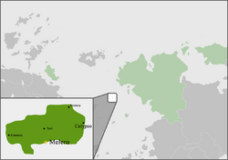
Ciulaga is located in the confluence of the Kindreds and Taínean Seas about 472 kilometres (293 mi) southwest of the coast of mainland Cartadania and about 879 kilometres (546 mi) southeast of the nearest sovereign country, Urcea, via Ventotene. It is due west of Santa Elena, about 229 kilometres (142 mi) from shore to shore. The total area of Ciulaga is 320.7 square kilometres (123.8 sq mi), of which 11 square kilometres (4.2 sq mi) is water and the rest land. Ciulaga is the 2nd largest island in Taíno-Kindredian confluence (Aveiro's Aragón and Salvador islands are considered to be wholly within the Taínean Sea). It stretches 32 kilometres (20 mi) in length and 97 kilometres (60 mi) in width. The highest point is the volcano of Mount Gistaín at 1,291 metres (4,236 ft) above sea level. There are numerous small islands, particularly off the east coast. Aside from the mountains of the center-west, Ciulaga is mostly flat, with rocky coasts to the north, irregular hills at the center, mangrove at the southwest, and white sand beaches sheltered by coral reefs along the southern shore, especially around Melero. This is where the main tourist resorts are found.
Climate
Ciulaga has a tropical climate tempered by maritime influences and the Trade Winds. There are two seasons, the dry season called "Lent" from January to June, and the wet season called "winter", from July to December.
| Climate data for Ciulaga | |||||||||||||
|---|---|---|---|---|---|---|---|---|---|---|---|---|---|
| Month | Jan | Feb | Mar | Apr | May | Jun | Jul | Aug | Sep | Oct | Nov | Dec | Year |
| Average high °C (°F) | 29.1 (84.4) |
29.1 (84.4) |
29.4 (84.9) |
30.1 (86.2) |
30.7 (87.3) |
31.3 (88.3) |
31.5 (88.7) |
31.6 (88.9) |
31.5 (88.7) |
31.2 (88.2) |
30.5 (86.9) |
29.6 (85.3) |
30.5 (86.9) |
| Daily mean °C (°F) | 24.5 (76.1) |
24.5 (76.1) |
24.9 (76.8) |
25.9 (78.6) |
26.9 (80.4) |
27.5 (81.5) |
27.6 (81.7) |
27.7 (81.9) |
27.4 (81.3) |
27.0 (80.6) |
26.3 (79.3) |
25.2 (77.4) |
26.3 (79.3) |
| Average low °C (°F) | 19.9 (67.8) |
19.9 (67.8) |
20.4 (68.7) |
21.7 (71.1) |
23.1 (73.6) |
23.8 (74.8) |
23.8 (74.8) |
23.7 (74.7) |
23.3 (73.9) |
22.9 (73.2) |
22.1 (71.8) |
20.9 (69.6) |
22.1 (71.8) |
| Average precipitation mm (inches) | 84 (3.3) |
64 (2.5) |
73 (2.9) |
123 (4.8) |
148 (5.8) |
118 (4.6) |
150 (5.9) |
198 (7.8) |
236 (9.3) |
228 (9.0) |
220 (8.7) |
137 (5.4) |
1,779 (70.0) |
| Average precipitation days | 15.0 | 11.5 | 11.5 | 11.6 | 13.6 | 12.8 | 15.4 | 16.2 | 16.6 | 18.1 | 16.6 | 15.7 | 174.6 |
| Mean monthly sunshine hours | 235.6 | 229.1 | 232.5 | 240.0 | 244.9 | 237.0 | 244.9 | 248.0 | 216.0 | 217.0 | 207.0 | 223.2 | 2,775.2 |
| Source: SNM Vila Real | |||||||||||||
Flora and fauna

Although the northwestern portion of the island catches most of the rainfall and is heavily forested, especially with its fertile volcanic soils and a warm climate, species such as bamboo, mahogany, rosewood and locust can be found across the island. The west coast is markedly drier and dominated by savanna-like brush, including cacti, Copaiba balsam, logwood, and acacia, but still contains much of the same lush vegetation as the rest of the island.
Between 300 and 1,000 m of altitude, the rainforest that covers a large part of the northwest develops. There, the white gum tree, chestnut tree, the Richerias and the oleander; shrubs and herbaceous plants such as the mountain palm, the balisier, or ferns; many epiphytes: bromeliads, philodendrons, orchids, and lianas. Above 1,000 m, the humid savanna develops, composed of mosses, lichens, sphagnum, or more vigorous plants such as mountain mangrove or high altitude violet.
Anole lizards and fer-de-lance snakes are native to the island. Bat species include the Maribel fruit bat, the Taínean fruit-eating bat, the Little yellow-shouldered bat, Davy's naked-backed bat, the Greater bulldog bat, Schwartz's myotis, and the Pelaxian free-tailed bat. There are very few terrestrial mammals on the island, except the aforementioned bats and the Fennec fox, a species introduced from Audonia to help with snakes. The waters of the islands, however, support a rich variety of marine life, mammals included.
Politics and government

Ciulaga is a Territory of First Class of Cartadania. Unlike with Lotoa and Porta Bianca, the federal government during the annexation of Ciulaga was UCon-controlled, and Congress did not incentivize relocation and development of Ciulaga until the shift of power in the early 20th century. Still, with support and oversight from its native Ciuma populace during the first few decades of the 20th century, Ciulaga was able to develop similarly to Santa Elena.
Ciulaga operates much the same as the other territories and states in terms of government. Executive authority in the territory rests with the governor. Both the Governor of Ciulaga and lieutenant governor are elected on separate ballots to four-year terms of office, limited to two terms. Most of the executive officials that comprise the governor's cabinet are elected by the citizens of Ciulaga rather than being appointed by the governor.
Legislative authority resides in the Ciulaga General Assembly, composed of the Senate and Chamber of Deputies. The Lieutenant Governor presides over the territory's senate, while members of the Chamber of Deputies select their own speaker. The Ciulaga Constitution sets the number of senators at 10, each of whom is elected from single-member districts. It also mandates a minimum of 40 deputies, apportioned among the representative districts. The territory currently sits at the legally defined number of 10 senators and 40 deputies, each of whom serves two-year terms with no limit. The territory laws are codified as the Code of Ciulaga. Following the National Congress's most recent session, President Kalanie and both houses have stated an effort to move all territories to statehood (except Alahuela, which will remain an independent city).
Administrative divisions
Ciulaga is divided into 6 municipios across the three regions–Oeste, Centro, Este. As a basis for the territory's ascension to statehood, municipios in Ciulaga have their own elected legislative branch, usually called the Board of Supervisors, which usually also has executive authority in the municipio. Ciulaga's constitution provides all municipios and cities with "home rule" authority. The boards have considerable power to pass legislation within their municipio, similar to how cities would.
Ciulaga recognizes all local units of government as cities, so all incorporated towns are legally cities by virtue of territorial law. While Ciulaga does not provide for townships or independent cities, it does allow consolidated city-municipio governments by way of local referendum, of which, Melero is the only consolidation to have occurred.
Economy
Transportation and communications
Demographics
Ethnic groups
Languages
Religion
Health
Education
Culture
Language

Ciulaga's official language is Cartadanian, which is spoken by nearly all of the population. 99% of Ciumas speak Cartadanian. They also speak a Cartadanian-based Creole that is also spoken in Porta Bianca, Santa Domenica, and Santa Elena also known as Odridian Creole.
Odridian Creole emerged as a result of the need for all ethnic groups (Sarpedonic, mainly Cartadanian, Audonian, and Taínean) to be able to understand each other. This language is therefore the result of a mixture created in the 17th century in response to a communicative emergency. Nonetheless, Cartadanian prevails as the primary language of Ciulaga due to travel needs of some Ciumas, along with the presence of Cartadanian citizens early in history that allowed saturation of the language.
As Ciulaga is a Cartadanian territory, Cartadanian is the official language. However, Taínean dialects of Cartadanian (in contact with Creole) have certain linguistic characteristics that differ from those of standard metropolitan Cartadanian. This regional Cartadanian has been little studied outside of Porta Bianca and most of the descriptions made refer to its lexicon and morphosyntax. However, there is now a detailed study of the phonetic aspect of Ciuma Cartadanian. It is also concerned with the reading varieties of Ciuma Cartadanian (acrolect, mesolect and basilect).
Music
The music of Ciulaga has evolved as a heterogeneous and dynamic product of diverse cultural resources. The most conspicuous musical sources have been Burgundie, Pelaxia, and Crona, although many aspects of Ciuma music reflect origins elsewhere in Sarpedon, Levantia, and other places within the Tainean basin (e.g., Porta Bianca) and Vallos, and, more recently, from Cartadania itself. Ciulaga's music culture today comprises a wide and rich variety of genres, ranging from indigenous genres to hybrids. This has been typical of the Taínean Basin states and territories, especially Porta Bianca.
Much of the music that is played today is heard in the other six territories and thirty-one states. However, Ciuma music is not mainstream in Cartadania and only some states have dedicated radio stations to the music, similar to the Suyaran situation. The central and eastern municipios tend to have more tropical style beats, incorporating sounds from steel drums, the cavaquinho, and various other instruments. This style of music, known as Oualie, originated in Porta Bianca and spread across the Taínean Sea to Ciulaga over multiple generations.
Festivals

Ciulaga's version of Carnival, is a four-day event beginning just before Lent and ending on its first day, with the burning of a papier-mâché figure symbolizing Carnival. Many small businesses close during Carnival, although some restaurants and other chains may remain open with abbreviated hours.
Like other Taínean Carnivals, Ciulaga's is a high-energy event with parades, singing, drums, and other festivities. People dress up in costumes, with devils and she-devils being especially popular. During Carnival in Ciulaga, many men parade in drag queen costume, sometimes with very elaborate and provocative outfits, with no obvious hint at alternative sexuality. It must be mentioned that traditionally, some women dressed as men for burlesque weddings as well. The high presence of men in drag is a reference to the central role of women in Ciulaga's society and family structure.
