Warrington Strait: Difference between revisions
Jump to navigation
Jump to search
Created page with "{{Infobox body of water | name = Warrington Strait | image = Warrington Straits.jpg | caption = The Warrington Straits as seen from the Arcer side. | image_bathymetry = | caption_bathymetry = | coords = | type = Sea Strait | inflow = Songun Sea | outflow = Malentine Sea | catchment = | basin_countries = Arcerion, Istrenya | length = | w..." |
m Added categories. Tag: 2017 source edit |
||
| (4 intermediate revisions by one other user not shown) | |||
| Line 2: | Line 2: | ||
| name = Warrington Strait | | name = Warrington Strait | ||
| image = Warrington Straits.jpg | | image = Warrington Straits.jpg | ||
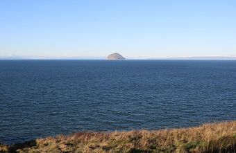
| caption = The Warrington Straits as seen from the Arcer side. | | caption = The Warrington Straits as seen from the Arcer side. | ||
| image_bathymetry = | | image_bathymetry = | ||
| caption_bathymetry = | | caption_bathymetry = | ||
| coords = | | coords = | ||
| type = [[Sea Strait]] | | type = [[Sea Strait]] | ||
| inflow = [[Songun Sea]] | | inflow = [[Songun Sea]] | ||
| outflow = [[Malentine Sea]] | | outflow = [[Malentine Sea]] | ||
| catchment = | | catchment = | ||
| basin_countries = [[Arcerion]], [[Istrenya]] | | basin_countries = [[Arcerion]], [[Istrenya]] | ||
| length = | | length = | ||
| width = | | width = | ||
| area = | | area = | ||
| depth = {{convert| | | depth = {{convert|646|m|abbr=on}} | ||
| max-depth = {{convert| | | max-depth = {{convert|922|m|abbr=on}} | ||
| volume = | | volume = | ||
| residence_time = | | residence_time = | ||
| shore = | | shore = | ||
| elevation = | | elevation = | ||
| frozen = | | frozen = | ||
| islands = | | islands = | ||
| cities = [[Chester-on-Moore]] | | cities = [[Chester-on-Moore]], [[Arcerion]] | ||
| reference = | | reference = | ||
}} | }} | ||
The Warrington Strait is a narrow strait that connects the [[Songun Sea]] and the [[Malentine Sea]] and separates the Southeastern [[Crona|Cronan]] peninsula from the Southwestern. | |||
Ferries cross between the Arcer City of [[Chester-on-Moore]] and the Istrenyan city of Maak'eln every day in times as short as an hour. The strait's depth ranges at its deepest point from two hundred to eight hundred metres. | |||
The strait lies in the territorial waters of [[Arcerion]] and [[Istrenya]], and under the [[League of Nations]] conventions on International Sea Traffic and Maritime Navigation all foreign vessels and aircraft have freedom of flight and navigation to cross the Strait in case of continuous transit. | |||
== Names and Etymology == | |||
== Location == | |||
=== Extent === | |||
== Geology == | |||
== Biodiversity == | |||
== History == | |||
== Communications == | |||
== Seaflow == | |||
== Territorial Waters == | |||
== Strategic Significance == | |||
== Sea Traffic and Commercial Sea Lanes == | |||
[[Category:Straits]] | |||
[[Category:Arcerion]] | |||
Latest revision as of 09:20, 7 September 2023
| Warrington Strait | |
|---|---|
 The Warrington Straits as seen from the Arcer side. | |
| Type | Sea Strait |
| Primary inflows | Songun Sea |
| Primary outflows | Malentine Sea |
| Basin countries | Arcerion, Istrenya |
| Average depth | 646 m (2,119 ft) |
| Max. depth | 922 m (3,025 ft) |
| Settlements | Chester-on-Moore, Arcerion |
The Warrington Strait is a narrow strait that connects the Songun Sea and the Malentine Sea and separates the Southeastern Cronan peninsula from the Southwestern.
Ferries cross between the Arcer City of Chester-on-Moore and the Istrenyan city of Maak'eln every day in times as short as an hour. The strait's depth ranges at its deepest point from two hundred to eight hundred metres.
The strait lies in the territorial waters of Arcerion and Istrenya, and under the League of Nations conventions on International Sea Traffic and Maritime Navigation all foreign vessels and aircraft have freedom of flight and navigation to cross the Strait in case of continuous transit.