South Sakartvelos: Difference between revisions
Sakartvelos (talk | contribs) mNo edit summary Tag: 2017 source edit |
Sakartvelos (talk | contribs) No edit summary Tag: 2017 source edit |
||
| Line 2: | Line 2: | ||
|conventional_long_name = The Democratic Republic of South Sakartvelos | |conventional_long_name = The Democratic Republic of South Sakartvelos | ||
|native_name = ''Демократическая Республика Южный Сакартвелос'' (Russian) | |native_name = ''Демократическая Республика Южный Сакартвелос'' (Russian) | ||
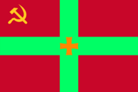
|image_flag = [[File:Flag of South Sakartvelos.png| | |image_flag = [[File:Flag of South Sakartvelos.png|200px]] | ||
|alt_flag = <!--alt text for flag (text shown when pointer hovers over flag)--> | |alt_flag = <!--alt text for flag (text shown when pointer hovers over flag)--> | ||
|flag_border = no | |flag_border = no | ||
| Line 8: | Line 8: | ||
|alt_flag2 = <!--alt text for second flag--> | |alt_flag2 = <!--alt text for second flag--> | ||
|flag2_border = <!--set to no to disable border around the flag--> | |flag2_border = <!--set to no to disable border around the flag--> | ||
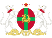
|image_coat = [[File:South Sakartvelos Coat of Arms.png| | |image_coat = [[File:South Sakartvelos Coat of Arms.png|200px]] | ||
|alt_coat = <!--alt text for coat of arms--> | |alt_coat = <!--alt text for coat of arms--> | ||
|symbol_type = <!--emblem, seal, etc (if not a coat of arms)--> | |symbol_type = <!--emblem, seal, etc (if not a coat of arms)--> | ||
| Line 15: | Line 15: | ||
|other_symbol_type = <!--Use if a further symbol exists, e.g. hymn--> | |other_symbol_type = <!--Use if a further symbol exists, e.g. hymn--> | ||
|other_symbol = | |other_symbol = | ||
|image_map = [[File:Urcea Locator.png| | |image_map = [[File:Urcea Locator.png|200px]] | ||
|loctext = <!--text description of location of country--> | |loctext = <!--text description of location of country--> | ||
|alt_map = <!--alt text for map--> | |alt_map = <!--alt text for map--> | ||
|map_caption = Location of South Sakartvelos (need map...)<br>[[Inferior Lands]] (gray) | |map_caption = Location of South Sakartvelos (need map...)<br>[[Inferior Lands]] (gray) | ||
|image_map2 = [[File:South Sakartvelos | |image_map2 = [[File:Map of South Sakartvelos with its cities.png|200px]] | ||
|alt_map2 = <!--alt text for second map--> | |alt_map2 = <!--alt text for second map--> | ||
|map_caption2 = Please put me in the map | |map_caption2 = Please put me in the map | ||
| Line 103: | Line 103: | ||
</gallery> | </gallery> | ||
' | South Sakartvelos, situated in the continent of [[Sarpedon]], boasts diverse and captivating geography. The country's landscape is predominantly characterized by lower lands, with the exception of a majestic mountain range that runs vertically through the nation, effectively dividing it into two distinct regions. The mountainous terrain serves not only as a natural boundary but also as a breathtaking backdrop to South Sakartvelos' cultural heritage. Numerous rivers crisscross the country, providing a source of life and sustenance for its people. These rivers have been harnessed to generate renewable energy, with hydroelectric dams dotting the landscape and contributing to the country's impressive 73% reliance on clean energy sources. | ||
South Sakartvelos is also home to several significant islands, each adding to the country's allure and charm. Among the notable islands are [[Grajnabad]] and [[Islaka]] Islands, located in the [[Alaka]] region, and [[Tumika]] Island in the [[Caucasia]] region. The [[Pelia]] region houses three islands: [[Kralank]] Island, [[Chepelia]] Island, and [[Tbisacap]] Island, each with unique features and natural wonders. These islands not only contribute to the country's economic and cultural diversity but also offer picturesque landscapes that attract tourists and nature enthusiasts from far and wide. | |||
The country's ten major cities are spread across different regions, each with its distinct characteristics shaped by the surrounding landscape. From the bustling capital of [[Tbirvozansk]] in the [[Tbivanistan]] region to the regional capitals such as [[Semzabad]] in [[Alaka]], [[Khyrdamir]] in [[Sasha]], [[Tsaghkapat]] in [[Caucasia]], and [[Vedalik]] in [[Peli]]a, each city offers a glimpse into South Sakartvelos' vibrant culture, history, and socio-economic dynamics. The geographical diversity of South Sakartvelos, encompassing mountains, rivers, islands, and cities, showcases a country that cherishes its natural heritage while embracing modern progress and sustainability. | |||
===Climate and environment=== | ===Climate and environment=== | ||
Revision as of 09:42, 2 August 2023
The Democratic Republic of South Sakartvelos Демократическая Республика Южный Сакартвелос (Russian) | |
|---|---|
Motto: Наша страна превосходит всех, кто посмеет приблизиться к тому, чтобы покончить с ней. ("Our country is superior to all who dare come close to ending it.") | |
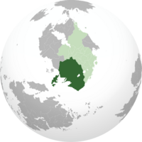 Location of South Sakartvelos (need map...) Inferior Lands (gray) | |
 Please put me in the map | |
| Capital | Tbirvozansk |
| Largest city | Your largest city (type "capital" for it to say "Capital and largest city") |
| Official languages | Russian |
| Religion | Orthodox Christianity |
| Demonym(s) | Georgian (noun) Sakartvelosian (adjective) |
| Government | Communist Democracy |
• President | Makvala Gelashvili |
• Speaker of the Senate | Ambrosi Giorgadze |
| Congress | |
| There is no lower house | |
| Establishment | |
• Independence of South Sakartvelos | 14/10/2024 |
| Population | |
• Estimate | 9,221,618 (2031) |
• Census | 9,219,542 (2030) |
| GDP (nominal) | estimate |
• Total | $361,321,436,476 |
• Per capita | $39,182 |
| Gini | 0.3 low |
| Currency | Siberian ruble (δ) (SBR) |
| Time zone | GMT+2 |
| Mains electricity | 220V 50HZ |
| Driving side | right |
| Calling code | +724 |
| Internet TLD | .skv |
South Sakartvelos, officially known as The Democratic Republic of South Sakartvelos, is a country located in the continent of Sarpedon. Following a fierce conflict against Soviet Yoshilandia, South Sakartvelos achieved independence on October 14, 2024. The country is characterized by its unique blend of democratic communism, where the economic system is based on communism, but leaders are democratically elected. Led by President Makvala Gelashvili, South Sakartvelos is divided into five provinces: Pelia, Caucasia, Sasha, Tbivanistan, and Alaka. The capital city, Tbirvozansk, located in Tbivanistan, serves as the country's political and cultural hub.
South Sakartvelos boasts a diverse political landscape, with three prominent political parties shaping its governance. The Communist Pact holds the majority in Congress with 89 out of 100 seats, including the presidency and the speaker of Congress. The Socialist Forward party commands seven seats, while the Liberal Party occupies three seats. Additionally, there is an independent representative in Congress. Legislation is formulated in the Supreme Court, underscoring the country's unique political structure.
The country's rich cultural heritage is rooted in its Slavic population, with Russian being the official language alongside Ukrainian, Georgian, and Serbian, which are also widely spoken. Christianity, particularly the Orthodox denomination, serves as the official state religion, although religious adherence is not mandatory. South Sakartvelos holds Dogs in high regard, symbolizing qualities of loyalty and bravery, while the hammer and sickle emblem represents communism, general equality, and the military. The nation thrives in three major industries: Arms Manufacturing, Information Technology, and Fishing. It demonstrates a commitment to sustainability, with 73% of its energy deriving from renewable sources, primarily hydroelectric power, due to its abundant rivers. Moreover, the country's efficient transportation network, encompassing railroads, buses, and ports, facilitates easy travel and connectivity throughout the nation. The GDP in Siberian Rubles is δ451,651,795,595 and the GDP/capita is δ48,977. South Sakartvelos is a member of the League of Nations. The land area is 1,071,630km² (665,880mi²).
Etymology
The name "South Sakartvelos" has its roots in a combination of historical, geographical, and cultural influences. The term "Sakartvelos" itself draws inspiration from the Georgian language, where it means "Georgia." The leader of the country, in a nod to both his deceased dog and South Georgia and the South Sandwich Islands, chose this name to indirectly pay homage to these elements. Despite the connection to Georgia, the country's official name remains South Sakartvelos to maintain a distinct identity.
The inclusion of "South" in the country's name signifies its location in the southern part of the continent of Sarpedon. Geographically, South Sakartvelos is primarily situated in lower-lying areas, aside from a prominent mountain range that runs vertically through the country, effectively dividing it into two regions. This mountain range serves as a defining feature and a natural boundary within the country. Moreover, the name "South Sakartvelos" emphasizes its position in the southwestern region of Sarpedon, anchoring its identity within the broader context of the continent.
History
South Sakartvelos has a tumultuous history, marked by its struggle for independence from Soviet Yoshilandia. After a brutal war, the country finally gained its freedom on October 14, 2024. Since then, South Sakartvelos has emerged as a democratic communist nation, where the communist economic system is combined with democratic elections to choose its leaders, fostering a unique political landscape in the region.
Soviet Yoshilandian Governance
During the period of Soviet Yoshilandia's control over South Sakartvelos, the country underwent a significant transformation. As an occupied territory, South Sakartvelos was subject to the influence of the Soviet regime, leading to substantial changes in various aspects of its society. Under Soviet rule, two official languages were enforced: Yoshi and Russian. This linguistic policy aimed to solidify the dominance of the occupying power while also facilitating communication and control within the region.
Additionally, the socio-political landscape of South Sakartvelos was reshaped to align with Soviet ideologies. The country experienced a shift toward a socialist system, with central planning and collective ownership becoming prominent features. Industries were nationalized, and agricultural collectivization was implemented, aiming to align South Sakartvelos with the broader Soviet economic model. The cultural fabric of the country also underwent changes, as Soviet influence led to the promotion of communist ideals and the suppression of certain cultural practices that did not align with the Soviet narrative. Despite the challenging circumstances, the people of South Sakartvelos preserved their identity and cultural heritage, laying the groundwork for their eventual struggle for independence.
Sparks for independence
The desire for independence surged among the people of South Sakartvelos as they yearned for self-determination and freedom from Soviet Yoshilandia's control. Grievances against the occupiers mounted, prompting the emergence of independence movements across the country. Fueled by a sense of national identity and a longing for autonomy, passionate activists and resistance groups began organizing, mobilizing the populace, and advocating for the liberation of South Sakartvelos.
These independence movements, often driven by a spirit of resilience and a desire for democratic governance, faced significant challenges in their fight for freedom. Under the watchful eye of the occupying forces, activists navigated a clandestine network, operating covertly to avoid detection and persecution. They engaged in acts of civil disobedience, disseminated information, and fostered a sense of unity and determination among their compatriots. Despite the risks involved, the people of South Sakartvelos demonstrated immense bravery and unwavering commitment to their cause, eventually culminating in a brutal war against Soviet Yoshilandia.
The War for Independence
The war of independence in South Sakartvelos was a grueling and arduous struggle that pitted the determined forces of the country against the formidable might of Soviet Yoshilandia. The conflict raged on for years, characterized by intense battles, guerrilla warfare, and acts of resistance. The people of South Sakartvelos showcased remarkable bravery and resilience as they fought for their freedom and the establishment of a sovereign nation.
During the war, South Sakartvelos faced numerous challenges, including the superior military capabilities of the occupying forces. However, the fighters of the independence movement exhibited resourcefulness and adaptability, utilizing guerrilla tactics and local knowledge of the terrain to their advantage. The conflict took place across the diverse landscapes of the country, from the lower lands to the mountainous regions, adding further complexity to the theater of war. The war exacted a heavy toll on both sides, with loss of life, displacement, and destruction of infrastructure as the price for independence. Nonetheless, the unwavering determination and unity of the South Sakartvelosian people ultimately led to victory, securing their independence on October 14, 2025, and laying the foundation for the democratic communist nation that would emerge in the aftermath of the conflict.
South Sakartvelos post-conflict
In the aftermath of the hard-fought war of independence, South Sakartvelos faced the daunting task of rebuilding and establishing a stable foundation for the newly liberated nation. The war had taken a heavy toll on the country, leaving behind a trail of devastation and challenges to overcome. The government, under the leadership of President Reziko Kapanadze, the first president of South Sakartvelos, embarked on a comprehensive reconstruction effort to rebuild infrastructure, restore essential services, and provide support for the war-affected population.
One of the primary focuses in the post-war period was the establishment of a democratic communist system that embodied the values of the newly independent South Sakartvelos. The government worked diligently to strike a balance between democratic principles and communist ideals, fostering a unique socio-political framework. Measures were implemented to ensure the fair representation of political parties, and the Congress, with the Communist Pact holding a significant majority, began the process of legislating and governing the nation. Efforts were also made to address the needs of the war-affected population, including the provision of healthcare, housing, and education, as the country sought to heal and move forward.
With resilience and determination, South Sakartvelos embarked on a path of nation-building and recovery, aided by international support and partnerships. The country focused on strengthening its economy through the revitalization of key industries, such as Arms Manufacturing, Information Technology, and Fishing. By leveraging its own innovations alongside imported ideas, South Sakartvelos sought to position itself as a progressive and self-sufficient nation. Investments were made in renewable energy, with a significant reliance on hydroelectric power and the development of nuclear plants, driving the country towards a more sustainable future. As South Sakartvelos rebuilt and stabilized, it began to emerge as a vibrant nation, proud of its hard-fought independence and eager to embrace the opportunities that lay ahead.
Modern-day South Sakartvelos
In modern-day South Sakartvelos, the country has solidified its position as a democratic communist nation, seamlessly blending elements of communism with democratic governance. President Makvala Gelashvili now leads the nation, overseeing a government that upholds the principles of equality, social justice, and collective progress. The political landscape remains characterized by the dominant Communist Pact, which holds a significant majority in Congress, while the Socialist Forward and Liberal Party provide alternative voices within the democratic system.
South Sakartvelos has made significant strides in various sectors, with a focus on sustainable development and innovation. The nation has harnessed its abundant rivers and invested in renewable energy, resulting in a remarkable 73% reliance on clean energy sources. The country's commitment to sustainability extends to transportation, with well-established railroads, efficient bus networks, and bustling ports facilitating domestic and international connectivity. The absence of widespread car usage contributes to reduced carbon emissions and a cleaner environment.
The resilient and resourceful people of South Sakartvelos have embraced their cultural heritage while embracing international collaborations. The Slavic population, the main cultural group, continues to shape the country's vibrant traditions and artistic expressions. South Sakartvelos has also become a hub for technological advancements, with its Information Technology sector thriving and contributing to the country's economic growth. Additionally, the arms manufacturing industry, rooted in the nation's history, remains robust, ensuring both national defense and export capabilities. With a strong emphasis on social welfare, South Sakartvelos provides universal healthcare to all citizens, reflecting its commitment to ensuring the well-being of its people. As South Sakartvelos looks to the future, it continues to navigate the delicate balance between democratic principles and communist ideals, striving for a prosperous and equitable society.
Geography
-
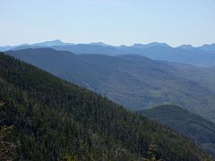
First lovely location
-
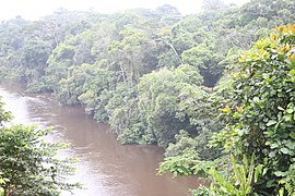
Second lovely location
-
Third lovely location
-
Fourth lovely location
-
Fifth lovely location
-
Sixth lovely location
South Sakartvelos, situated in the continent of Sarpedon, boasts diverse and captivating geography. The country's landscape is predominantly characterized by lower lands, with the exception of a majestic mountain range that runs vertically through the nation, effectively dividing it into two distinct regions. The mountainous terrain serves not only as a natural boundary but also as a breathtaking backdrop to South Sakartvelos' cultural heritage. Numerous rivers crisscross the country, providing a source of life and sustenance for its people. These rivers have been harnessed to generate renewable energy, with hydroelectric dams dotting the landscape and contributing to the country's impressive 73% reliance on clean energy sources.
South Sakartvelos is also home to several significant islands, each adding to the country's allure and charm. Among the notable islands are Grajnabad and Islaka Islands, located in the Alaka region, and Tumika Island in the Caucasia region. The Pelia region houses three islands: Kralank Island, Chepelia Island, and Tbisacap Island, each with unique features and natural wonders. These islands not only contribute to the country's economic and cultural diversity but also offer picturesque landscapes that attract tourists and nature enthusiasts from far and wide.
The country's ten major cities are spread across different regions, each with its distinct characteristics shaped by the surrounding landscape. From the bustling capital of Tbirvozansk in the Tbivanistan region to the regional capitals such as Semzabad in Alaka, Khyrdamir in Sasha, Tsaghkapat in Caucasia, and Vedalik in Pelia, each city offers a glimpse into South Sakartvelos' vibrant culture, history, and socio-economic dynamics. The geographical diversity of South Sakartvelos, encompassing mountains, rivers, islands, and cities, showcases a country that cherishes its natural heritage while embracing modern progress and sustainability.
Climate and environment
Is your country hot or cold?
Government and Politics
How is your country ruled or governed?
Executive
Who is responsible for making high level choices in your country? Does it have a President or King?
Legislative
Who decides the laws for your country? Is there political parties and a legislature?
Federal subdivisions
How is your country divided? Are there states or provinces, or is the country directly governed from the capital as a unitary state?
Politics
What political factions exist? Who has ruled predominantly?
Law
What kind of laws and legal system does your country employ?
Demographics
What kind of people live in your country?
Ethnicity
What ethnic groups make up your country?
Language
What language or languages do your country's people use? Are there any previously used languages no longer common? Are these languages native to your country or shared with another?
Religion
Religious affiliations in the XXX (20XX)
What do your country's people believe in religiously, if anything? How many groups are there?
Education
How many people in your country are educated?
Culture and Society
What do your people do, and what are they like?
Education
What is your country's education system like? How do the schools work? What do people think about education?
Attitudes and worldview
How do your country's people view life?
Kinship and family
How are families or kinship groups structured in your country?
Cuisine
What do your people eat?
Religion
What do your people believe? Rather than demographics, as above, think about how important religion is to your people and their view about their own and other religions. What is the relationship between the prevailing view and minority religious groups? Is it an official religion, and do any laws exist about free worship?
Arts and Literature
What type of art do your people make? Do they have a tradition of painted art, well-crafted television shows, or great music?
Sports
Does your country have any major sports leagues? What types of sports are played, both professionally and for fun by your country's people?"
Symbols
Are there any prominent symbols which are well known to represent your country?
Economy and Infrastructure
How does your country's economy work?
Industries and Sectors
What are the largest parts of your economy in terms of what they do?
Currency
What exchange systems are used within your country's economy?
Healthcare
How do people in your country procure medical care? How is it paid for?
Labor
How is labor organized within your country? Are there any social institutions or unions which deal with labor concerns?
Transportation
How do people in your country get around? Is there a major highway system as well as sea- and airports?
Energy
What type of energy keeps your nation going? Are you renewable or use fossil fuels, and if you are renewable, how recently did your country transition?
Technology
How advanced is your country? Is it an innovator, or does it largely import new developments?
Military
How large is your country's military? Is it large but poorly equipped or small and elite? Does your country have a martial tradition?
