Alshar: Difference between revisions
m →List of nations: Tanhai flag added. |
mNo edit summary |
||
| Line 54: | Line 54: | ||
|- | |- | ||
|3 | |3 | ||
| style="text-align:left;" | | | style="text-align:left;" |[[File:HuoxiaFlag99.png|23px]] [[Huoxia]] | ||
| style="text-align:left;" | | | style="text-align:left;" |38,955,020 | ||
| style="text-align:left;" | | | style="text-align:left;" | | ||
| style="text-align:left;" | | | style="text-align:left;" | | ||
|- | |- | ||
|4 | |4 | ||
| style="text-align:left;" | [[Kagoyama]] | |||
| style="text-align:left;" |104,635,197 | |||
| style="text-align:left;" | | |||
| style="text-align:left;" | | |||
|- | |||
|5 | |||
| style="text-align:left;" |[[File:Somali Pirates Flag.svg|23px]] [[Kandara]] | | style="text-align:left;" |[[File:Somali Pirates Flag.svg|23px]] [[Kandara]] | ||
| style="text-align:left;" |14,600,000 | | style="text-align:left;" |14,600,000 | ||
| style="text-align:left;" |{{convert|1223692|km2|sqmi|abbr=values|sortable=on}} | | style="text-align:left;" |{{convert|1223692|km2|sqmi|abbr=values|sortable=on}} | ||
| style="text-align:left;" |{{convert|11.93|km2|sqmi|abbr=values|sortable=on}} | | style="text-align:left;" |{{convert|11.93|km2|sqmi|abbr=values|sortable=on}} | ||
|- | |- | ||
|6 | |6 | ||
| Line 84: | Line 84: | ||
|- | |- | ||
|8 | |8 | ||
| style="text-align:left;" | | | style="text-align:left;" | Peshabiwar | ||
| style="text-align:left;" |3,540,580 | | style="text-align:left;" |3,540,580 | ||
| style="text-align:left;" |{{convert|426079|km2|sqmi|abbr=values|sortable=on}} | | style="text-align:left;" |{{convert|426079|km2|sqmi|abbr=values|sortable=on}} | ||
| Line 90: | Line 90: | ||
|- | |- | ||
|9 | |9 | ||
| style="text-align:left;" | | | style="text-align:left;" |[[Pukhgundi]] | ||
| style="text-align:left;" |42,600,400 | | style="text-align:left;" |42,600,400 | ||
| style="text-align:left;" |{{convert|1047909|km2|sqmi|abbr=values|sortable=on}} | | style="text-align:left;" |{{convert|1047909|km2|sqmi|abbr=values|sortable=on}} | ||
| Line 96: | Line 96: | ||
|- | |- | ||
|10 | |10 | ||
| style="text-align:left;" | | | style="text-align:left;" |[[Pursat]] | ||
| style="text-align:left;" |104,569,500 | | style="text-align:left;" |104,569,500 | ||
| style="text-align:left;" |{{convert|1196626|km2|sqmi|abbr=values|sortable=on}} | | style="text-align:left;" |{{convert|1196626|km2|sqmi|abbr=values|sortable=on}} | ||
| Line 102: | Line 102: | ||
|- | |- | ||
|11 | |11 | ||
| style="text-align:left;" |[[File: | | style="text-align:left;" |[[File:RUflag.png|23px]] [[Rusana]] | ||
| style="text-align:left;" |54,650,440 | | style="text-align:left;" |54,650,440 | ||
| style="text-align:left;" |{{convert|794582|km2|sqmi|abbr=values|sortable=on}} | | style="text-align:left;" |{{convert|794582|km2|sqmi|abbr=values|sortable=on}} | ||
| Line 114: | Line 114: | ||
|- | |- | ||
|13 | |13 | ||
| style="text-align:left;" |[[File: | | style="text-align:left;" |[[File:A_flag_(2).png|23px]] [[Tashi-Daypa]] | ||
| style="text-align:left;" |21,122,423 | |||
| style="text-align:left;" | | |||
| style="text-align:left;" | | |||
|- | |||
|14 | |||
| style="text-align:left;" |Tapakdore | |||
| style="text-align:left;" |74,605,870 | | style="text-align:left;" |74,605,870 | ||
| style="text-align:left;" |{{convert|645503|km2|sqmi|abbr=values|sortable=on}} | | style="text-align:left;" |{{convert|645503|km2|sqmi|abbr=values|sortable=on}} | ||
Revision as of 18:19, 10 January 2023
 | |
| Area | 61,578,803.73 km2 (23,775,709.04 sq mi) |
|---|---|
| Population | 1,572,893,240 |
| Population density | 25.54 km2 (9.86 sq mi) |
| Demonym | Alshari |
| Countries | 13 states |
| Languages | List of languages: Kloi Corummese Kandaran Lebhan |
| Time zones | TBD |
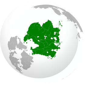
Alshar is a continent and geographic region located in the Eastern Hemisphere of the globe. Alshar is bound to the south by the Pukhthun Sea, the Sea of Capelan to the north, the Ocean of Cathay to the east and the Audonian landmass and the Levantine Sea to the west. Through millenia of habitation it has been home to many empires and expansive civilizations. It is the second most populated continent and the third largest by total landmass.
It is divided into thirteen sovereign states with the most notable being Kloistan, Duamacia, Corumm and Metzetta. Two Levantine states are in possession of colonial holdings namely the Fiannrian territory of Soirwind and various islands owned by Burgundie in the continent's periphery. Central and south eastern Alshar are much more densely populated than the northern regions which are for the most part, endless grassland and steppes.
Etymology
The continent has several widely used names. The most commonly used, "Alshar", descends from the Arabic word الشرق (lit. "east", "alshrq"). The term is thought to have originated with Occidental explorers being sent to the continent east of Audonia, referred to the explorers simply as the "eastern land".
History
The Alshari landmass is home to some of the oldest civilizations known to man
Economy
Demographics
Ethnic Groups
Corummese
Duamese
Metzettan
Kloi
Assorted Subhumans
Religion
Alshar is home to a broad range of religious denominations. Islam was brought over to southern Alshar by the expanding Oduniyyad caliphate in the 800's and today both Sunni, Shia Twelver and smaller schools have large number of adherents in various parts of the continent. In similar fashion Christianity arrived by way of missionaries arriving with Levantine colonizers and while the majority of its current practitioners are of Levantine descent, smaller native congregations do exist under some of the more tolerant regimes. Forms of animism and ancestor worship are widespread. Corumm enforces an almost blanket ban on all religions thereby being one of the only nations to have state enforced atheism.
Languages
List of nations
| Rank | Country (or dependent territory) | Population (2025) | Area in km2 (sq mi) | Density in per/km2 (per/sq mi) |
|---|---|---|---|---|
| 1 | 32,152,365 | 511,134 (197,350) | 62.90 (24.29) | |
| 2 | 698,168,695 | 1,979,269 (764,200) | 352.74 (136.19) | |
| 3 | 38,955,020 | |||
| 4 | Kagoyama | 104,635,197 | ||
| 5 | 14,600,000 | 1,223,692 (472,470) | 11.93 (4.61) | |
| 6 | 77,000,000 | 821,078 (317,020) | 93.78 (242.89) | |
| 7 | 17,435,619 | |||
| 8 | Peshabiwar | 3,540,580 | 426,079 (164,510) | 8.31 (3.21) |
| 9 | Pukhgundi | 42,600,400 | 1,047,909 (404,600) | 40.65 (15.70) |
| 10 | Pursat | 104,569,500 | 1,196,626 (462,020) | 421.66 (162.80) |
| 11 | 54,650,440 | 794,582 (306,790) | 68.78 (26.56) | |
| 12 | 347,569,060 | 1,857,151 (717,050) | 187.15 (72.26) | |
| 13 | 21,122,423 | |||
| 14 | Tapakdore | 74,605,870 | 645,503 (249,230) | 115.58 (44.63) |