Serikorda and Crona: Difference between pages
m (Text replacement - "Taństem" to "Eshavian") |
m (→History) |
||
| Line 1: | Line 1: | ||
{{ | {{wip}} | ||
{{Template:OOD}} | |||
{{Infobox continent | |||
|title = Crona | |||
|image = CronaMap1.PNG | |||
|area = {{convert|999999|km2|sqmi|abbr=on}} | |||
|population = <sup>wip</sup> | |||
|density = <sup>wip</sup> | |||
|GDP_nominal = | |||
|GDP_PPP = | |||
|demonym = Cronan<br>Cronite | |||
|countries = | |||
|list_countries = | |||
|dependencies = Most | |||
|languages = [[Blairian Ænglish|Alstinian Ænglish]],[[Hieratic Varshani|Hieratic Varshani]], Coscivian, others | |||
|time = | |||
|cities = Largest urban areas:<br />[[Taisgol]]<br />[[Alstin (City)|Alstin]]<br />Anzo<br />Farpoint<br>Kurst | |||
}} | |||
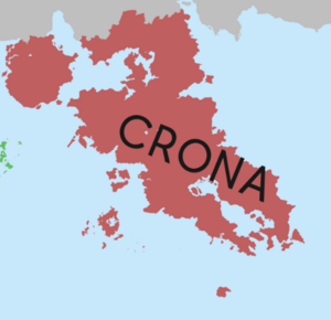
'''Crona''' is a continent. | |||
{| | To the [[Occidental civilization]], it was first extensively explored and charted by [[Paul Aster]] in his [[Aster's expedition|1387 expedition]]. | ||
| | |||
==Name== | |||
==Extent== | |||
===Regions=== | |||
==== Greater Nysdra Region ==== | |||
The Greater Nysdra region is | |||
Most economists and scholars believe the level of poverty and lack of developed economies in the Greater Nysdra region are a result of historic hegemony by [[Varshan]], who extracted significant amount of both tribute and slaves from its neighbors during the second millennia AD. The lack of wealth and viable agricultural manpower lead to severe economic degradation in most of countries in the region while enhancing Varshan's economy, allowing it to construct modern weapons and import [[Occidental]] novelties for its ruling classes. | |||
[[File:Rough Crona Map 1.png|thumb|Map of Cronan Regions]] | |||
==== Central region ==== | |||
==== Songun Region ==== | |||
{{Further|North Songun civilization}} | |||
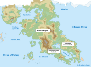
The Songun Region, also referred to as South Crona, comprises the nations located in the Southeastern and Southwestern Cronan Peninsulas, as well as the [[Alstinian Isles]]. South Crona possesses the most economically prosperous nations in Crona, largely owing to the Occidental settlement that occurred in this region from the 15th to 20th centuries. | |||
===Countries, dependencies, and other territories=== | |||
{| class="wikitable sortable" | |||
!Rank | |||
!Country (or dependent territory) | |||
!Population (2025) | |||
!Area in km<sup>2</sup> (sq mi) | |||
!Density in per/km<sup>2</sup> (per/sq mi) | |||
|- | |||
|1 | |||
| Anta Carda | |||
|36,990,780 | |||
|<span data-sort-value="7011418826950000000♠"></span>418,826.95 (161,709.99) | |||
|<span data-sort-value="7007883200000000000♠"></span>88.32 (34.10) | |||
|- | |||
|2 | |||
|Arctic Tribal Lands | |||
|8,350,305 | |||
|<span data-sort-value="7012363056747000000♠"></span>3,630,567.47 (1,401,769.94) | |||
|<span data-sort-value="7006320000000000000♠"></span>3.2 (1.2) | |||
|- | |||
|3 | |||
|Ceylonia | |||
|34,866,975 | |||
|<span data-sort-value="7011892458000000000♠"></span>892,458 (344,580) | |||
|<span data-sort-value="7007390600000000000♠"></span>39.06 (15.08) | |||
|- | |- | ||
| | |4 | ||
|Eastern Reaches | |||
|136,604,240 | |||
|<span data-sort-value="7012122749891000000♠"></span>1,227,498.91 (473,939.98) | |||
|<span data-sort-value="7008111280000000000♠"></span>111.28 (42.97) | |||
|- | |- | ||
| | |5 | ||
|Ehemo | |||
|93,540,365 | |||
|<span data-sort-value="7012100729813000000♠"></span>1,007,298.13 (388,919.98) | |||
|<span data-sort-value="7007928600000000000♠"></span>92.86 (35.85) | |||
|- | |- | ||
| | |6 | ||
|Galicia | |||
|18,529,217 | |||
|<span data-sort-value="7011727528000000000♠"></span>727,528 (280,900) | |||
|<span data-sort-value="7007254600000000000♠"></span>25.46 (9.83) | |||
|- | |- | ||
| | |7 | ||
|Hikara | |||
|51,378,475 | |||
|<span data-sort-value="7011671350780000000♠"></span>671,350.78 (259,209.99) | |||
|<span data-sort-value="7007765300000000000♠"></span>76.53 (29.55) | |||
|- | |- | ||
| | |8 | ||
|Kelekona | |||
|73,465,525 | |||
|<span data-sort-value="7012125860466000000♠"></span>1,258,604.66 (485,949.98) | |||
|<span data-sort-value="7007583700000000000♠"></span>58.37 (22.54) | |||
|- | |- | ||
| | |9 | ||
|Northern Confederation | |||
|51,075,840 | |||
|<span data-sort-value="7012217066894000000♠"></span>2,170,668.94 (838,099.96) | |||
|<span data-sort-value="7007235300000000000♠"></span>23.53 (9.08) | |||
|- | |- | ||
| | |10 | ||
|Pankara | |||
|150,879,635 | |||
|<span data-sort-value="7011982278840000000♠"></span>982,278.84 (379,259.98) | |||
|<span data-sort-value="7008153600000000000♠"></span>153.60 (59.31) | |||
|- | |- | ||
| | |11 | ||
|Porlos | |||
|6,808,983 | |||
|<span data-sort-value="7011219786380000000♠"></span>219,786.38 (84,860.00) | |||
|<span data-sort-value="7007309800000000000♠"></span>30.98 (11.96) | |||
|- | |- | ||
| | |12 | ||
| Punthite Republic | |||
|141,226,570 | |||
|<span data-sort-value="7012106241307000000♠"></span>1,062,413.07 (410,199.98) | |||
|<span data-sort-value="7008132930000000000♠"></span>132.93 (51.32) | |||
|- | |- | ||
| | |13 | ||
|Sabnaki | |||
|7,711,800 | |||
|<span data-sort-value="7011343510100000000♠"></span>343,510.10 (132,629.99) | |||
|<span data-sort-value="7007224500000000000♠"></span>22.45 (8.67) | |||
|- | |- | ||
| | |14 | ||
|Southern Tribes | |||
|30,984,340 | |||
|<span data-sort-value="7012134073318000000♠"></span>1,340,733.18 (517,659.97) | |||
|<span data-sort-value="7007231100000000000♠"></span>23.11 (8.92) | |||
|- | |- | ||
| | |15 | ||
|Telonaticolan | |||
|39,320,050 | |||
|<span data-sort-value="7012138256149000000♠"></span>1,382,561.49 (533,809.98) | |||
|<span data-sort-value="7007284400000000000♠"></span>28.44 (10.98) | |||
|- | |- | ||
| | |16 | ||
| Ulaga | |||
|2,707,330 | |||
|<span data-sort-value="7011145790420000000♠"></span>145,790.42 (56,290.00) | |||
|<span data-sort-value="7007185700000000000♠"></span>18.57 (7.17) | |||
|- | |- | ||
| | |17 | ||
| Varshan | |||
|752,144,212 | |||
|<span data-sort-value="7012793116500000000♠"></span>7,931,165.00 (3,062,239.93) | |||
|<span data-sort-value="7007948300000000000♠"></span>94.83 (36.61) | |||
|- | |- | ||
| | |18 | ||
|Walawaku | |||
|5,136,785 | |||
|<span data-sort-value="7011524161770000000♠"></span>524,161.77 (202,379.99) | |||
|<span data-sort-value="7006980000000000000♠"></span>9.8 (3.8) | |||
|- | |- | ||
| | |19 | ||
|Western Federation | |||
|35,716,390 | |||
|<span data-sort-value="7012288967551000000♠"></span>2,889,675.51 (1,115,709.95) | |||
|<span data-sort-value="7007123600000000000♠"></span>12.36 (4.77) | |||
|- | |- | ||
| | |20 | ||
|West Punth Territories | |||
|26,506,045 | |||
|<span data-sort-value="7012145637615000000♠"></span>1,456,376.15 (562,309.98) | |||
|<span data-sort-value="7007182000000000000♠"></span>18.20 (7.03) | |||
|- | |- | ||
| | |21 | ||
|Wild Lands | |||
|3,532,570 | |||
|<span data-sort-value="7011483913350000000♠"></span>483,913.35 (186,839.99) | |||
|<span data-sort-value="7006730000000000000♠"></span>7.3 (2.8) | |||
|- | |- | ||
| | |22 | ||
|Tierrador | |||
|101,604,230 | |||
|<span data-sort-value="7011524161770000000♠"></span>2,041,817.78 (788,350.99) | |||
|<span data-sort-value="7006980000000000000♠"></span>49.76 (122.88) | |||
|- | |- | ||
| | |22 | ||
|Zospiyjan | |||
|} | |} | ||
==History== | ==History== | ||
===Natural history=== | |||
===Prehistory and early history=== | |||
===Growth of civilization=== | |||
===Occidental exposure and Varshani growth=== | |||
===Relative decline of Anzo and globalization=== | |||
===The Deluge=== | |||
== | ===Post-Deluge=== | ||
====Nysdrine mediatization==== | |||
=== | |||
=== | |||
=== | |||
== | |||
==Natural characteristics== | |||
===Geology=== | |||
===Climate=== | |||
===Ecology=== | |||
==Demographics== | |||
===Languages=== | |||
===Religion=== | |||
===Population=== | |||
===Cultural groups=== | |||
==Economy== | ==Economy== | ||
[[Category: Common Core]] | |||
[[Category: IXWB]] | |||
[[Category: Continents]] | |||
{{Geography topics}} | |||
[[ | |||
Revision as of 16:32, 27 September 2023
This article is a work-in-progress because it is incomplete and pending further input from an author. Note: The contents of this article are not considered canonical and may be inaccurate. Please comment on this article's talk page to share your input, comments and questions. |
This article or section is out of date because it is either legacy lore from a participant who is no longer here or because it has been rendered obsolete by new lore. Note: To contribute to this article, you may need to seek help from the author(s) of this page. |
 | |
| Area | 999,999 km2 (386,102 sq mi) |
|---|---|
| Population | wip |
| Population density | wip |
| Demonym | Cronan Cronite |
| Dependencies | Most |
| Languages | Alstinian Ænglish,Hieratic Varshani, Coscivian, others |
| Largest cities | Largest urban areas: Taisgol Alstin Anzo Farpoint Kurst |
Crona is a continent.
To the Occidental civilization, it was first extensively explored and charted by Paul Aster in his 1387 expedition.
Name
Extent
Regions
Greater Nysdra Region
The Greater Nysdra region is Most economists and scholars believe the level of poverty and lack of developed economies in the Greater Nysdra region are a result of historic hegemony by Varshan, who extracted significant amount of both tribute and slaves from its neighbors during the second millennia AD. The lack of wealth and viable agricultural manpower lead to severe economic degradation in most of countries in the region while enhancing Varshan's economy, allowing it to construct modern weapons and import Occidental novelties for its ruling classes.

Central region
Songun Region
The Songun Region, also referred to as South Crona, comprises the nations located in the Southeastern and Southwestern Cronan Peninsulas, as well as the Alstinian Isles. South Crona possesses the most economically prosperous nations in Crona, largely owing to the Occidental settlement that occurred in this region from the 15th to 20th centuries.
Countries, dependencies, and other territories
| Rank | Country (or dependent territory) | Population (2025) | Area in km2 (sq mi) | Density in per/km2 (per/sq mi) |
|---|---|---|---|---|
| 1 | Anta Carda | 36,990,780 | 418,826.95 (161,709.99) | 88.32 (34.10) |
| 2 | Arctic Tribal Lands | 8,350,305 | 3,630,567.47 (1,401,769.94) | 3.2 (1.2) |
| 3 | Ceylonia | 34,866,975 | 892,458 (344,580) | 39.06 (15.08) |
| 4 | Eastern Reaches | 136,604,240 | 1,227,498.91 (473,939.98) | 111.28 (42.97) |
| 5 | Ehemo | 93,540,365 | 1,007,298.13 (388,919.98) | 92.86 (35.85) |
| 6 | Galicia | 18,529,217 | 727,528 (280,900) | 25.46 (9.83) |
| 7 | Hikara | 51,378,475 | 671,350.78 (259,209.99) | 76.53 (29.55) |
| 8 | Kelekona | 73,465,525 | 1,258,604.66 (485,949.98) | 58.37 (22.54) |
| 9 | Northern Confederation | 51,075,840 | 2,170,668.94 (838,099.96) | 23.53 (9.08) |
| 10 | Pankara | 150,879,635 | 982,278.84 (379,259.98) | 153.60 (59.31) |
| 11 | Porlos | 6,808,983 | 219,786.38 (84,860.00) | 30.98 (11.96) |
| 12 | Punthite Republic | 141,226,570 | 1,062,413.07 (410,199.98) | 132.93 (51.32) |
| 13 | Sabnaki | 7,711,800 | 343,510.10 (132,629.99) | 22.45 (8.67) |
| 14 | Southern Tribes | 30,984,340 | 1,340,733.18 (517,659.97) | 23.11 (8.92) |
| 15 | Telonaticolan | 39,320,050 | 1,382,561.49 (533,809.98) | 28.44 (10.98) |
| 16 | Ulaga | 2,707,330 | 145,790.42 (56,290.00) | 18.57 (7.17) |
| 17 | Varshan | 752,144,212 | 7,931,165.00 (3,062,239.93) | 94.83 (36.61) |
| 18 | Walawaku | 5,136,785 | 524,161.77 (202,379.99) | 9.8 (3.8) |
| 19 | Western Federation | 35,716,390 | 2,889,675.51 (1,115,709.95) | 12.36 (4.77) |
| 20 | West Punth Territories | 26,506,045 | 1,456,376.15 (562,309.98) | 18.20 (7.03) |
| 21 | Wild Lands | 3,532,570 | 483,913.35 (186,839.99) | 7.3 (2.8) |
| 22 | Tierrador | 101,604,230 | 2,041,817.78 (788,350.99) | 49.76 (122.88) |
| 22 | Zospiyjan |