File:Kandara Political Map.png: Difference between revisions
Jump to navigation
Jump to search
(Political map of Kandara) |
mNo edit summary Tag: 2017 source edit |
||
| (3 intermediate revisions by the same user not shown) | |||
| Line 1: | Line 1: | ||
== Summary == | == Summary == | ||
Political map of Kandara | Political map of [[Kandara]] | ||
[[Category:Maps of Burgundie]] | |||
[[Category:Maps]] | |||
[[Category: Political Geography]] | |||
[[Category:IXWB]] | |||
[[Category:Burgundie media]] | |||
[[Category:Kandara]] | |||
Latest revision as of 21:08, 19 October 2023
Summary
Political map of Kandara
File history
Click on a date/time to view the file as it appeared at that time.
| Date/Time | Thumbnail | Dimensions | User | Comment | |
|---|---|---|---|---|---|
| current | 16:32, 19 October 2023 | 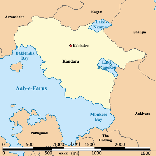 | 500 × 500 (32 KB) | Burgundie (talk | contribs) | |
| 22:51, 21 March 2023 |  | 500 × 500 (24 KB) | Burgundie (talk | contribs) | Political map of Kandara |
You cannot overwrite this file.
File usage
The following page uses this file: