Talk:Chaukhira
Geology
Chaukhira is an archipelago of 5 islands in the southern mouth of the Aab-e-Farus. The waters around the islands are called the al-Zelaq Straits.
The largest and most western island is called Chaukhira Maior (the small island off of it's northeastern coast is called Chaukhira Minor and is hardly referenced uniquely). The second largest, to the northeast is Taizerbo, the smallest to the extreme north east is Taoulga, coming back to the southwest is Ghat, and in the center of the island cluster is Akhdaran.
The islands are the remains of a land bridge that used to connect the southern two continental islands of Alshar. At the end of the last ice age when sea levels rose, the Aab-e-Farus overtopped the lower laying areas of the land bridge and only the islands of Chaukhira and those big islands to the south remain.
Because of this phenomenon, the geography that remains to form the island chain is hilly with low lying areas being built up by silty undercurrents coming from the Aab-e-Farus. This makes the northern coasts very fertile and verdant. The northern faces of the hilly landscape is also quite fertile as the Antarctic atmosphere pulls warm air out of the Aab-e-Farus extending the growing season and keeping it humid year round.
Over the past few thousand years of human settlement the nutrient rich silt has been spread throughout the islands, but the heavily rains in the monsoon season rapidly erode anything that is not secured by deep roots. As such much of the islands hillsides have been terraced for cultivation and rivers and streams have been the subject of extensive terraforming and human intervention.
The islands of Chaukhira are home to a myriad of small naval and Revenue Guard stations, and airstrips. While Chaukhira is a key component of La Garrote it became effectively cut off from the maritime world when the 1982 LON Law of the Sea passed the Economic Exclusion Zone provision, essentially codifying that marine traffic to and from Chaukhira must pass through the waters of other nations. Since that time there have been no instances of a restriction of the Freedom of the seas in the Aab-e-Farus or the al-Zelaq Straits, but the Navy of Burgundie's Grand Eastern Command is postured for a break out of Chaukhira in the event of war. As such the largest naval base on the islands is primarily used as a transit port and not a permanent station for any of the commands largest and most valuable ships. It has no large scale drydock facilities and berthed ships are never allowed to fully turn off their engines and systems. As such, it is one of the most hated billets or transit points for sailors because liberty is always limited on scope and duration.
Climate
Chaukhira= Northern most point: 31.371S, southern most point: 34.530 S
- Climate of Sydney northern tip
- Cf: Subtropical Humid
old climate pics
to be moved to a more appropriate climate
-
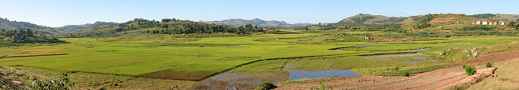 rice paddy
 -

-

-

-

-

-

-

-
-

-

-

-

-


.jpg)


.jpg)
.jpg)

.jpg)

.jpg)