Geography of Burgundie
Burgundie is made up of a series of mainland counties and electorate counties on the continent of Levantia, a capital island, a "home" island approximately 850 kilometers off of its northern shore and "trade" islands scattered across Greater Ixnay. Due to the historical importance of the maritime realm, the sea around and between the landed counties and the islands are also considered as much a part of Burgundie as its terra firma.
The capital island consists of the Electorate of Burgundie and is the administrative and historical center of the republic. It is located 156 miles north of the Levantine northern coast. The "home" island of Wintergen is located 855 kilometers northeast of the Electorate of Burgundie in the midst of the Kilikas Sea. It is considered a home island because following its occupation in 1823, most of the Kiravian settlers left and the island was colonized by the Burgundians.
The trade islands of AyerSee, Nyö, Sodermark, ... and Sturmhavn are scattered throughout Greater Ixnay.
Contents
- 1 Climate
- 1.1 Insular Burgundie
- 1.1.1 Belrac Caldera
- 1.1.2 Isle of Burgundie
- 1.1.2.1 Isle of Burgundie Hydrology
- 1.1.2.2 Isle of Burgundie Flora
- 1.2 Dericania
- 1.2.1 Martilles
- 1.2.1.1 Martillian Hydrology
- 1.2.1.2 Martillian Flora
- 1.2.1 Martilles
- 1.3 Burgundian Dericania
- 1.4 Flordeterra
- 1.5 Other Overseas Territories
- 1.1 Insular Burgundie
- 2 Physical Geography of Burgundie
- 2.1 Insular Burgundie
- 2.2 Dericania
- 2.3 Burgundian Dericania
- 2.4 Flordeterra
- 2.5 Other Overseas Territories
- 3 See Also
Climate
Spanning the climate classifications of Tropical Wet, Tropical Wet/Dry, Semiarid, Humid Subtropical, Subarctic, Tundra, and Ice Cap the Burgoignesc Thalassocrasy has a megadiverse climate. The thalassocracy is often divided into continental groups to group these classifications to describable groupings. These climatological divisions are the Burgoignesc Metrolpole, Audonian and Alshari Burgundie, Sarpedonian Burgundie, Australian Burgundie, and Kiro-Borealian Burgundie.
Burgoignesc Metropole

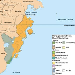
The Burgoignesc Metropole, also known as Levantine Burgundie, encompasses the nation of Burgundie and the Commonwealth Trade Island of Levantx. In its southern most tip it has a tropical wet climate which becomes a tropical wet/dry climate as it moves north into the hinterlands. Moving along the coast to the northeast the area is entirely humid subtropical including Levantx.
Physical Geography of Burgundie
Because of its disparate locations, Burgundie has many different forms of geography.
Insular Burgundie
Topography of Insular and Levantine Burgundie
This includes the islands of the Isle of Burgundie, Nauta Normand, and Wintergen.
Dericania
Main article: Dericania
Geographically, Dericania consists of a series of defining features. From west to east they generally fall into the Paulus Peninsula, the Southern Spine, the Burgundian Caldera and the Eastern Plain.
Burgundian Dericania
Burgundian Dericania is constituted of the provinces of Adtaran, Bonavix, Cashen, Drusla, Eagaria, Esquinia, and Pumbria.
Flordeterra
Main article: Flordeterra
Flordeterra is constituted of the provinces of Equitorial Burgundie, Hoheseen, Monsunboch, and Neu Burgund.