Brumalea
This article is considered abandoned lore either because its creator has changed projects or has left the community. Accordingly, it is not only non-canon but it is also eligible for salvage pending approval from an administrator.
|
The Brumal Domains | |
|---|---|
Motto: Blessed be Brumalea | |
Anthem: [Tune to the Brumals] | |
 | |
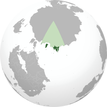
| Location | The Brumal Domains lining east Kiroborea |
| Capital | Leidtoun |
| Largest city | New Dunaird |
| Official languages | Anglish |
| Recognised national languages | Anglish, Algosh, Carnish |
| Recognised regional languages | Fhasen |
| Ethnic groups (2022) |
|
| Religion | Christian deism, M'acunism |
| Demonym(s) | Brumal, Brumalean |
| Government | Federal parliamentary republic |
• Prime Minister | Nadie Wawetseka |
• Minister for Brumal Relations | Arran Ferguson |
| Legislature | Parliament |
| House of Dominions | |
| House of Commons | |
| Establishment | |
• Cusinautic Indigenous Settlement | ~1300 CE |
• Anglish Settlement | 1542 CE |
• Brumal Dominions incorporated into Carnish Empire | August 11th, 1600 |
• Brumal Dominions declare independence | June 26th, 1948 |
• Statute of Barbara (Carnish Kingdom direct-rule begins) | June 30th, 1948 |
• Statute of Clara (Constitutional monarchy proclaimed) | August 11th, 1986 |
• Brumal Domains proclaimed, end of monarchy | June 8th, 2004 |
| Area | |
• Total area | 721,311.7 km2 (278,500.0 sq mi) |
• Water (%) | ~0% |
• Total land area | 2,033,633 km2 (785,190 sq mi) |
| Population | |
• 2022 estimate | 8.3 million |
• Density | 79.8/km2 (206.7/sq mi) |
| GDP (nominal) | 2022 estimate |
• Total | $258,000,000,000 |
• Per capita | $31,084 |
| Gini (2020) | 26.8 low |
| HDI (2020) | 0.930 very high |
| Currency | Thaler (₮) |
| Date format | mm/dd/yyyy CE |
| Mains electricity | 120 V 60 Hz |
| Driving side | right |
| Calling code | +41 |
| ISO 3166 code' | BR |
| Internet TLD | .br |
The Brumal Domains, sometimes simply referred to as Brumalea, is a country in Kiroborea consisting of a series of territories along the Sea of Nordska. The territories were first settled by Cusinautic indigenous settlers following game across the arctic in order to study their migration patterns. Upon crossing the arctic the landmass of New Inverleith and the island of New Kaigwa were discovered and settled. Due to the distance between the lands and Cusinaut however no attempt was made to incorporate the territory into any of the various Cusinautic indigenous tribal lands. The Cusinautic Indigenous population of the lands steadily grew from the 13th century onward, with permanent settlements being established along New Kaigwa and the Brumal Mountains of New Inverleith. Carnish explorers arrived to the lands latter while circumnavigating Levantia in the 16th century. Looking to avoid Urcean river access to the Vandarch, explorers ventured north to the Kilikas Sea. With conflict raging in Prevalia and Faneria however, expedition into the Vandarch was refocused on establishing contact with the states along the Levantine Ocean. The Carnish explorers were quickly blown of course however upon entering the violent waters of the Sea of Nordska. While keeping sight of the coast the explorers were unknowingly following the coast of Kiroborea, and instead discovered and claimed the uninhabited Kiroborean lands for the Kingdom of Carna. Brumalean history from this point forward is defined almost entirely by the Anglish and Carnish settlement of the islands, and by the beginning of the 20th century the islands had amassed a population of 7 million. In 1948 the Brumalean Domains declared independence as the Carnish Revolution began. This independence was brief however, as the Carnish royal family fled to Brumalea and began ruling the colonies directly as the Brumal Dominions. This arrangement would last until 1986, when Queen Clara and the government of the Brumal Dominions established a new constitution. The Brumal Dominions were henceforth ruled as a constitutional monarchy, until a referendum was held in 2004 to abolish the monarchy.
Etymology
The Brumal Domains were named such after the cold year-round climate of the area. Though parts of the country are more amicable, such as New Dunaird, New Holchester, and southern New Inverleith, the country is generally not suited for agriculture. When the Anglo-Carnish settlers discovered the islands they were not initially referred to by a collective name, but were rather individually named to the names each province in the country holds today. The name Brumal Dominions was first used upon formal incorporation of the territories into the Kingdom of Carna. Due to the low population and desolate nature of the lands, they were collectively named the Brumal Dominions. Upon abolition of the monarchy the country henceforth went by the Brumal Domains. Brumalea is not the official name of the country in any capacity, but is much more commonly used amongst the populace.
History
Cusinautic Indigenous Settlement of Brumalea

Prior to Anglo-Carnish discovery of the Brumal Domains, the lands settled in New Inverleith were known as Wacîwaskiy, while New Kaigwa was known by the same name in Algosh, Oskaigwa. The land was settled sporadically and lightly upon first discovery. Fauna had been found to migrate between Crona and Brumalea and animals in the area were plentiful. While this encouraged further settlement it also deterred the northern chiefdoms of Cusinaut from pursuing the incorporation of land so far across the desolate arctic. Large igloo communities were set up across the arctic to facilitate trans-polar migration, and Cusinautic Indigenous colonists were able to remain in Brumalea permanently through remaining in indirect contact with their chiefdoms. The largest settlement, Wâpaskâw, was built just over the Brumal Mountains at the northernmost point of King Ewan II Bay on New Inverleith. This settlement lay north of the arctic timberline, and thus could only be supported through the arctic caravan system. Building materials were brought from Crona in exchange for native beaver and seal pelt, and settlement was able to grow as such. Periods of harsh weather brought down many a smaller settlement however, so while Wâpaskâw still stands to this day, most Cusinautic Indigenous settlements in the north do not remain in their pre-Carnish discovery form. To this day the trans-arctic caravan network remains active among natives and is cooperatively maintained by Algoquona and Brumalea, though ownership over the route is not recognized by any sovereign state aside from one another.
The various Cusinautic Indigenous settlements of Brumalea were largely homogenous and maintained similar cultures to their Cronan counterpart. Dependence on the trans-arctic trade route forced the disparate communities to remain cooperative. This would change however, as Wâpaskâw grew more influential and took attention away from Oskaigwa. The degree to which this conflict reflected an organized war effort is debated and still researched amongst Brumal historians today, but at the very least the Oskaigwan communities mobilized together to disrupt the Wacîwaskiy trade routes in an effort to hijack the incoming resources. The remains of hundreds of Cusinautic Indigenous people and sled dogs are scattered across the Nordskan arctic coast, along with resources such as timber, pelt, stone weaponry, and more. The results of this conflict are unknown, though it seems both sides suffered large casualties. Through dating of artifacts along the trans-arctic trade route, it would seem this period of heightened conflict provoked the northern communities of Cusinaut to cease trading with the Brumalean settlements until the conflict was resolved. It is likely then that this conflict ended in a stalemate, with both communities being able to resume trade by the end of the mid-15th century.

Maritime expeditions began some time in the late-15th century, though these were seemingly initially unsuccessful. No Cusinautic Indigenous communities exist outside of New Inverleith and New Kaigwa, and the waters freezing over for half of the year prevented both Wacîwaskiy and Oskaigwa from developing significant maritime capabilities. Fishing villages did pop up along the coast of New Inverleith however, with prominent settlements like Natakam and Mistikowaskîy at the tip of the eastern peninsula and along the western shore near the Ardrades respectively. These settlements were able to develop more independently than Wacîwaskiy and Oskaigwa due to the presence of various pines in the southern lands. Natakam and Mistikowaskîy grew in population significantly quicker than Oskaigwa and Wacîwaskiy, and the entirety of Brumalea soon numbered 100,000 Algosh, concentrated in the Brumal Mountains and along the coast of New Inverleith. This population growth culminated in the Mistikowaskîy and Natakam both establishing independent chiefdoms, while the northern settlements remained connected to the trans-polar trade route but unorganized. Natakam was able to successfully reach all of the inner Ardrades by the turn of the 14th century and establish multiple fishing communities on the islands. The communities organized into the Natakam Nation, and quickly produced their explorers as their maritime successes numbered greater than their failures. Though not settled in significant numbers, the Cusinautic Indigenous people were able to reach the outer Ardrades and had made attempts to chart the coastline of the Brumal Domains. The latest ship found along the coast of Brumalea dates back to 1540 CE, with no other indigenous wrecks found near shore. Oral storytellers from the Natakam Nation proport exploration abruptly stopping due to the disappearance of Matunaagd Waban, he who fights the east wind. Traces of his voyage to the Inver Straits of King Ewan II Bay have been found such as temporary settlements dating to the time of his voyage, but where he and his crew departed to next is a mystery. No Natakam explorer had ever ventured very far from the Brumal mainland, so it is unlikely Waban made it to any of the Levantine Ocean islands. Dive teams from New Dunaird have scoured the ocean floor in hope of finding Waban's wreck, but have had no such luck to date. The nations of Natakam, Mistikowaskîy, Wacîwaskiy, and Oskaigwa exist to this day as self-governing nations within the Brumal Domains. Upon contact with the first Anglo-Carnish explorers the Cusinautic Indigenous peoples had mixed reactions. The Natakam and Mistikowaskîy were quick to welcome the incoming settlers while the Wacîwaskiy and other northern communities were hesitant to become involved with the foreigners. Having fought over the trans-arctic trade routes the Wacîwaskiy refused to interact with the Anglo-Carnish, and stopped settlement of the northern territories to the best of their ability before further Anglo-Carnish settlement began. The Oskaigwa remained uncontacted for some time due to their remoteness compared to the communities of New Inverleith. By the time of contact with the Oskaigwa the Anglo-Carnish had already established a significant foothold on New Inverleith, so the Oskaigwans had received word of their arrival through the trans-arctic trade route years earlier.
Geography

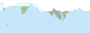
Brumalea is located at the convergence of three separate tectonic plates: the Boreal plate defining the Wâpaskâw range, the Nordskan plate defining the Rose mountain range splitting the western peninsula in two, and the Mystic plate to the east of the Rose mountains. The plates form a tripoint convergence and make the Wâpaskâw and Rose mountains look to be one mountain range. The Wâpaskâw range divides the country apart from its northern Boreal sector while the Rose mountains divide the populated capital region from the coastal communities of Natakam. The western peninsula is home to a magma hotspot underneath the dormant Mystic super-volcano of the Mystika province. The mainland and King Duncan's Land are fed by several large rivers from the various mountains of the country, while the outlying island of the Ardrades and New Dunaird are comparatively low-lying and flat. Oskaigwa and New Holchester are situated far from the core of the country and rely on the more self-sufficient mainland and neighboring Caergwynn and Faneria.
Government and Politics
Administrative Divisions of Brumalea
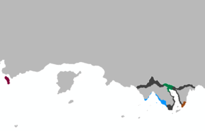
Brumalea is divided into 15 provinces and 2 territories. The provinces and territories are all functionally the same, but the two administrative territories exist with more transient borders past the Brumal mountains. As such, an internal border exists between the territories and the northern provinces of Brumalea, as the territories of Brumalea can legally be entered over land without a passport. All 17 administrative divisions are represented by a Premier in the House of Dominions, and these Premiers also serve as the elected leaders of each province. Each province is responsible for various responsibilities delineated to them by the federal government, such as healthcare, education, road maintenance, provincial justice, etc. All 17 provinces and territories have been constitutionally defined since 2004, with the adoption of the country's new constitution.
| Abbreviation | Name | Population | Area (sq mi) | Population Density (/sq mi) |
|---|---|---|---|---|
| AD | Ardrades | 230,400 | 555 | 415.14 |
| BB | Beulbaigh | 1,242,180 | 11,198 | 110.93 |
| BE | Brumal East | 70,928 | 38,256 | 1.85 |
| BW | Brumal West | 210,458 | 23,489 | 8.96 |
| CH | Chistika | 150,493 | 5,974 | 25.19 |
| GL | Gleandon | 64,544 | 25,385 | 2.54 |
| KM | King Malcolm's Land | 42,772 | 2,042,820 | 0.02 |
| LT | Leidtoun | 2,289,675 | 5,409 | 423.31 |
| MY | Mystika | 130,450 | 17,038 | 7.66 |
| NA | Natakam | 638,466 | 5,893 | 108.34 |
| ND | New Dunaird | 2,464,235 | 485 | 5,080.90 |
| NH | New Holchester | 565,677 | 1,189 | 475.76 |
| OK | Oskaigwa | 103,658 | 24,611 | 4.21 |
| PT | Pitimak | 36,871 | 25,358 | 1.45 |
| RS | Rosenatia | 84,522 | 6,423 | 13.16 |
| WC | Waciawasky | 44,893 | 2,348,394 | 0.02 |
| WP | Wapaskaw | 334,980 | 21,655 | 15.47 |

