Arcerion: Difference between revisions
Tag: 2017 source edit |
|||
| Line 130: | Line 130: | ||
''Main article: [[Geography of Arcerion]]'' | ''Main article: [[Geography of Arcerion]]'' | ||
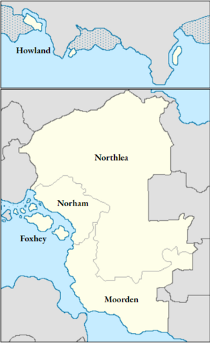
[[File:Governorates.PNG|thumb|An overview of Arcerion as divided into the governorates.]] | [[File:Governorates.PNG|thumb|An overview of Arcerion as divided into the governorates.]] | ||
The total area of Arcerion is approximately 1,538,478 km<sup>2</sup> (594,010 sq mi). The country occupies a large portion of the [[Southeastern Cronan Peninsula]] as well as a significant portion of the [[Malentine Isles]]. Arcerion borders on two inland seas, the Malentine and the Songun, with a considerable amount of internal rivers, lakes, and wetlands. Arcerion shares national borders with Kelekona and Titechaxha to the North, as well as the New Archduchy. To the South, it shares the Washakaran Basin with Washakara, as well as Paulastra. Arcerion's maritime borders on those of Malentina. In the Polar Arctic, Howland Governorate is closely neighboured by the Alpachnee Confederation. | The total area of Arcerion is approximately 1,538,478 km<sup>2</sup> (594,010 sq mi). The country occupies a large portion of the [[Southeastern Cronan Peninsula]] as well as a significant portion of the [[Malentine Isles]]. Arcerion borders on two inland seas, the Malentine and the Songun, with a considerable amount of internal rivers, lakes, and wetlands. Arcerion shares national borders with Kelekona and Titechaxha to the North, as well as the New Archduchy. To the South, it shares the Washakaran Basin with Washakara, as well as Paulastra. Arcerion's maritime borders on those of Malentina. In the Polar Arctic, Howland Governorate is closely neighboured by the Alpachnee Confederation. | ||
In 2026, 22% of Arcerion was covered by deciduous forest, and 18% being covered by sub-tropical forests. An overwhelmingly majority of Arcerion's central Arcer Heartland is lowland plains, of which the majority (>66%) is used for agriculture and farming. | In 2026, 22% of Arcerion was covered by deciduous forest, and 18% being covered by sub-tropical forests. An overwhelmingly majority of Arcerion's central Arcer Heartland is lowland plains, of which the majority (>66%) is used for agriculture and farming. | ||
| Line 136: | Line 136: | ||
=== Climate === | === Climate === | ||
Most of Arcerion has a temperate climate, with generally cool to warm temperatures and a mixture of climates ranging from sub-tropical to temperate and rainy. The temperature varies by season and region, with the lowest recorded temperature in the Arcer mainland being -10 °C ([[Ashden]], [[Northlea Governorate]]), and the highest being 36 °C (Foxhey, [[Foxhey Governorate]]). Arcerion's climate outlier is the arctic province of Howland Governorate, with temperatures in the summer averaging around 10-15 °C, and in the winter as cold as -40 °C. The Northumbraeland Mountains have distinct climate challenges for weather forecasters and meteorologists as their proximity to the Odoneru Ocean allows it to act as a buffer, with warmer oceanic winds mixing with cooler inland temperatures resulting in significant snowfall. | Most of Arcerion has a temperate climate, with generally cool to warm temperatures and a mixture of climates ranging from sub-tropical to temperate and rainy. The temperature varies by season and region, with the lowest recorded temperature in the Arcer mainland being -10 °C ([[Ashden]], [[Northlea Governorate]]), and the highest being 36 °C (Foxhey, [[Foxhey Governorate]]). Arcerion's climate outlier is the arctic province of Howland Governorate, with temperatures in the summer averaging around 10-15 °C, and in the winter as cold as -40 °C. The Northumbraeland Mountains have distinct climate challenges for weather forecasters and meteorologists as their proximity to the Odoneru Ocean allows it to act as a buffer, with warmer oceanic winds mixing with cooler inland temperatures resulting in significant snowfall. | ||
In the Arcer mainland, the prevailing wind is from the Southwest, coming from the Malentine Sea, although parts of Easthampton and Northern portions of Northlea Governorate have different wind warming patters due to mountains and lowlands. The majority of rainfall and precipitation falls in [[Foxhey Governorate|Foxhey]], [[Northlea Governorate|Northlea]], and [[Norham Governorate|Norham Governorates]] as they are on the Malentine Coast. Howland experiences the highest average precipitation, however the majority of this is snowfall. Summers are the warmest in the South in the Aileach Foothills towards Chester-on-Moore, and cooler towards the Northern portions of the Arcer Heartland. | In the Arcer mainland, the prevailing wind is from the Southwest, coming from the Malentine Sea, although parts of Easthampton and Northern portions of Northlea Governorate have different wind warming patters due to mountains and lowlands. The majority of rainfall and precipitation falls in [[Foxhey Governorate|Foxhey]], [[Northlea Governorate|Northlea]], and [[Norham Governorate|Norham Governorates]] as they are on the Malentine Coast. Howland experiences the highest average precipitation, however the majority of this is snowfall. Summers are the warmest in the South in the Aileach Foothills towards Chester-on-Moore, and cooler towards the Northern portions of the Arcer Heartland. | ||
=== Topography === | === Topography === | ||
==== Physical Geography ==== | ==== Physical Geography ==== | ||
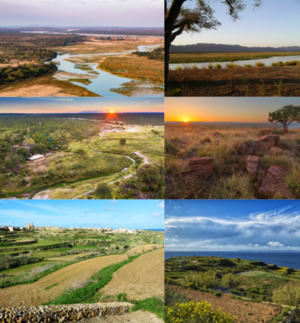
Arcerion's [[Geography of Arcerion|physical geography]] varies greatly by state. In Northlea, the large sweeping plains are cultivated and planted near the rivers. For example, the Leigh and Innis rivers provide the water to grow crops that help feeds millions of people across Crona, as Northlea's wheat and staple crop farms thrive in the plains heat when properly irrigated and fertilized. Northlea itself is home to these plains almost entirely, with few exceptions for marshes or river wetlands due to the heat. In Moorden, the mountains rise up to form a cooler biome, where the lowlands meet the towering Eastern Mountains. These mountains also are home to one of the few places in Arcerion where, weather permitting, annual snowfall does occur. This gives certain areas of Easthampton the strange ability to be on a riverside villa on one day, and skiing the next. However the climates and biomes of the Arcer mainland are only part of the equation, as closer to the coast the geography changes considerably. The coastline is lush, green, and dotted with coastal farms and fishing communities, some of which are large enough that they have small berths for cargo ships and light railyards. | Arcerion's [[Geography of Arcerion|physical geography]] varies greatly by state. In Northlea, the large sweeping plains are cultivated and planted near the rivers. For example, the Leigh and Innis rivers provide the water to grow crops that help feeds millions of people across Crona, as Northlea's wheat and staple crop farms thrive in the plains heat when properly irrigated and fertilized. Northlea itself is home to these plains almost entirely, with few exceptions for marshes or river wetlands due to the heat. In Moorden, the mountains rise up to form a cooler biome, where the lowlands meet the towering Eastern Mountains. These mountains also are home to one of the few places in Arcerion where, weather permitting, annual snowfall does occur. This gives certain areas of Easthampton the strange ability to be on a riverside villa on one day, and skiing the next. However the climates and biomes of the Arcer mainland are only part of the equation, as closer to the coast the geography changes considerably. The coastline is lush, green, and dotted with coastal farms and fishing communities, some of which are large enough that they have small berths for cargo ships and light railyards. | ||
[[File:Geography.png|thumb|Clockwise, from top left. The Lowland Plains of Northlea; the rivers and mountains of Moorden Governate; the lowland areas between Oakham and Northlea Governates; backcountry lowland plains in Northlea; patchwork farmland in Foxhey Governate; the Arcer Coastline. ]] | |||
In Foxhey, across the Malentine, the geography is influenced by the proximity to the sea and the reliance on farming and commercial fishing. Small fishing villages, as well as patchwork farms dot the picture-eqsue landscape. | In Foxhey, across the Malentine, the geography is influenced by the proximity to the sea and the reliance on farming and commercial fishing. Small fishing villages, as well as patchwork farms dot the picture-eqsue landscape. | ||
| Line 151: | Line 151: | ||
==== Innis River Basin ==== | ==== Innis River Basin ==== | ||
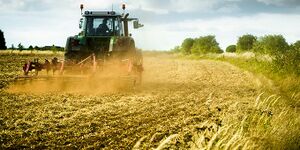
[[File:Farming.jpg|thumb|A farmer in the Arco governate of Northlea uses a tractor during the planting season (March, 2021). ]] | [[File:Farming.jpg|thumb|A farmer in the Arco governate of Northlea uses a tractor during the planting season (March, 2021). ]] | ||
== Economy and Infrastructure == | == Economy and Infrastructure == | ||
=== Economy === | === Economy === | ||
Revision as of 05:23, 27 April 2023
Confederated Provinces of Arcerion Arco Confederacy | |
|---|---|
Motto: Belecgan ûser ingangan "To Defend What Has Been Built" | |
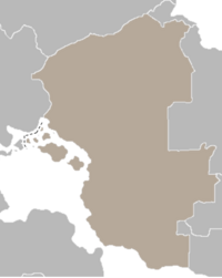 Arcerion's mainland borders in South Crona | |
| Capital and largest city | Kurst Capital Region |
| Official languages | Ænglish |
| Official languages | Ænglish |
| Ethnic groups |
|
| Religion |
|
| Demonym(s) | Arco, Arcer |
| Government | non-partisan Republican which is considered a semi-direct democracy |
| Iain Donnegal | |
| Martha Atherington | |
| Arcer Senate | |
| Confederate Parliament | |
| Independent Sovereign State Semi-Independence Granted 1890, Full Sovereign Status Assumed with end of Ardmori Civil War | |
| Population | |
• 2019 estimate | 89,863,541 |
• Density | Template:Convinfobox/sec2 |
| GDP (nominal) | estimate |
• Total | $2.957 trillion |
• Per capita | $52,301 |
| Currency | Arcer Pound (A&P) |
| Driving side | right |
| Internet TLD | .arc |
Arcerion, officially the Confederated Provinces of Arcerion, is a country in Southern Crona. It shares land borders with Kelekona to the North, as well as Titechaxha. It covers an area of 1,538,478 km2 (594,010 sq mi) which includes the islands of Foxhey as well as several smaller islands. The country has a population of almost 90 million, the vast majority of which is situated within the country's coastal regions but with strong agricultural towns through the central highlands. It is a decentralized republic comprising 4 major governates, and almost forty minor counties. The national capital is Kurst, the country's second largest city and economic centre. Other major cities include Kinnaird, Craigfearn, Dalfearn, Oakham, Presdale, Easthampton, and Dunborough.
Arcerion's colonial roots reach back to its settlement and founding as an Ardmori colony in the late 18th century. Arcer culture was formed and shaped during this time to reflect the settler and frontier mindset, forging a national identity that is currently referred to as Arco Determinism. Arcerion played a significant role in Crona's development in the 19th, 20th, and 21st centuries. As a major Occidental nation with a large economy, developed national security apparatus, and strong civil institutions, it has been a bastion of democracy and commerce since its founding two hundred years prior. The nation is religious, the majority of Arcers subscribing to a mixture of Catholicism or other related religions, although a slowly growing irreligious movement amongst younger generations has continued to trend higher. Arcerion is highly developed amongst its city centres and large towns, ranking highly on the Human Development Index (HDI) and has one of the largest economies in South Crona. Arcerion's arable farmland and large agriculture sector means that it is relied upon for foodstuffs by most of its Indigenous neighbors, and its significant energy production (both nuclear, coal, and LNG) mean that it plays an outstated role in the South Cronan power grid.
Arcerion's foreign policy is a mixture of pro-free market and capitalist missions, such as its strong relationships with Urcea, Burgundie, and the New Archduchy, as well as traditional anti-socialist alliances and cultural ties with nations like Alstin. Arcerion also has made inroads into the Polynesian Sea, identifying Stenza as an emerging partner, with Arco-Stenzan relationships strengthening both economically and militarily since 2000. Arcerion maintains tepid and infrequent diplomatic relationships with non-Occidental nations in Crona, due to Indigenous support for Communism and Socialism in the Fourth Bush War and historical animosity between Ardmori and Gaelic settlers and Indigenous tribes.
Etymology
Arcerion's Etymology roughly can be translated based of early Ardmori settlers language morphing into a local Arco subset of the Ænglish language. The prefix 'ar' means 'high', whereas the suffix "Ceirean" is roughly translated to that of a sea monster. It is inferred from this that early Ardmori settlers believed that a sea monster lived off the coast of Chester-on-Moore, in what is now the Songun Sea. Based off of the wreck of two different ships, they named the place "Ar-Ceirean" which over time was changed through local dialects and spelling to "Air-cerion," with a meaning translating to the place by the cliffs where monsters are.
Geography
Main article: Geography of Arcerion
The total area of Arcerion is approximately 1,538,478 km2 (594,010 sq mi). The country occupies a large portion of the Southeastern Cronan Peninsula as well as a significant portion of the Malentine Isles. Arcerion borders on two inland seas, the Malentine and the Songun, with a considerable amount of internal rivers, lakes, and wetlands. Arcerion shares national borders with Kelekona and Titechaxha to the North, as well as the New Archduchy. To the South, it shares the Washakaran Basin with Washakara, as well as Paulastra. Arcerion's maritime borders on those of Malentina. In the Polar Arctic, Howland Governorate is closely neighboured by the Alpachnee Confederation. In 2026, 22% of Arcerion was covered by deciduous forest, and 18% being covered by sub-tropical forests. An overwhelmingly majority of Arcerion's central Arcer Heartland is lowland plains, of which the majority (>66%) is used for agriculture and farming.
Arcerion contains a series of terrestrial ecoregions that are distinct climates or distinct climate areas. These are the Arcer Heartland, Northern Madagáin Forest, and the Northumbraeland Forest.
Climate
Most of Arcerion has a temperate climate, with generally cool to warm temperatures and a mixture of climates ranging from sub-tropical to temperate and rainy. The temperature varies by season and region, with the lowest recorded temperature in the Arcer mainland being -10 °C (Ashden, Northlea Governorate), and the highest being 36 °C (Foxhey, Foxhey Governorate). Arcerion's climate outlier is the arctic province of Howland Governorate, with temperatures in the summer averaging around 10-15 °C, and in the winter as cold as -40 °C. The Northumbraeland Mountains have distinct climate challenges for weather forecasters and meteorologists as their proximity to the Odoneru Ocean allows it to act as a buffer, with warmer oceanic winds mixing with cooler inland temperatures resulting in significant snowfall.
In the Arcer mainland, the prevailing wind is from the Southwest, coming from the Malentine Sea, although parts of Easthampton and Northern portions of Northlea Governorate have different wind warming patters due to mountains and lowlands. The majority of rainfall and precipitation falls in Foxhey, Northlea, and Norham Governorates as they are on the Malentine Coast. Howland experiences the highest average precipitation, however the majority of this is snowfall. Summers are the warmest in the South in the Aileach Foothills towards Chester-on-Moore, and cooler towards the Northern portions of the Arcer Heartland.
Topography
Physical Geography
Arcerion's physical geography varies greatly by state. In Northlea, the large sweeping plains are cultivated and planted near the rivers. For example, the Leigh and Innis rivers provide the water to grow crops that help feeds millions of people across Crona, as Northlea's wheat and staple crop farms thrive in the plains heat when properly irrigated and fertilized. Northlea itself is home to these plains almost entirely, with few exceptions for marshes or river wetlands due to the heat. In Moorden, the mountains rise up to form a cooler biome, where the lowlands meet the towering Eastern Mountains. These mountains also are home to one of the few places in Arcerion where, weather permitting, annual snowfall does occur. This gives certain areas of Easthampton the strange ability to be on a riverside villa on one day, and skiing the next. However the climates and biomes of the Arcer mainland are only part of the equation, as closer to the coast the geography changes considerably. The coastline is lush, green, and dotted with coastal farms and fishing communities, some of which are large enough that they have small berths for cargo ships and light railyards.
In Foxhey, across the Malentine, the geography is influenced by the proximity to the sea and the reliance on farming and commercial fishing. Small fishing villages, as well as patchwork farms dot the picture-eqsue landscape.
Average temperature for mainland Arcerion during the summers ranges from 8° at night to 39° during the day. The hottest day on record in Arcerion was recorded in Presdale, at 46°. During the winter, on average the lowest temperature at night is -4°, and during the day highs of 15°. Generally, this means that farming can continue almost year-round, as long as farmers keep a watchful eye out for frost or early winter low temperatures.
Strategic Geography
Albion Sea Gas Fields
Warrington Straits
Arcer Heartland
Innis River Basin
Economy and Infrastructure
Economy
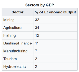
The Arcer economy can be considered to be robust, and is appraised by most to be a mix market economy, although some government regulators wish to see a greater emphasis on command-style economic policies to protect Arco interests. This leads to the population of ~89,000,000 having a GDP per capita of $52,301, and a total national GDP of $2.957 trillion. Economists would consider the Arcer economy to be Agrarian/Industrial, with most pointing out that Arcerion can't seem to decide if it wants to fully embrace industry or retain its agricultural and traditional economic practices. The Arcer economy revolves predominantly around its exports, and is an export-focused economy, being almost self-sufficient. Its main exports are usually defined by the governate that they emanate from, with each of the four governates having a distinctly different economic intake and output.
Foxhey, the smallest of the Arco governates, has a mostly agrarian economy. It also boasts a healthy fishing sector, which thrives during the Malentine Sea's spring and summer. Characterized by its traditional economy, the small towns and villages export wheat, barley, and other grain crops. It is ranked as one of the most productive economies from a provincial-standpoint in Arcerion. The second-smallest economy comes from Norham, in the Northeast. Due to political instability along the Northern Arco border, Norham is essentially a slightly larger version of Foxhey. Small cottage farms and local market industry define its exports, and its lone port town, Norpool Cross, is the most Northern port in the Malentine, making it a central hub for imports to much of the Upper Peninsula. The two giants of the Arcer economy, the twin governates of Northlea and Moorden can at best be contrasted by their cities and rural areas. In Northlea, the cities are bustling centers of market economic power, with stock exchanges, banks, and financial institutions serving as the white-collar backbone of the governate's economy. Beyond the cities, Northlea's vast size and rolling plains are covered in patchwork industrial farms, with government subsidies on farming machinery and equipment allowing it to become the breadbasket of the South-Eastern Peninsula. This serves in direct contrast to Moorden. Moorden's large mountains are home to some of Crona's largest industrial mining facilities, and the governate's capital, Easthampton, is a massive industrial city with large manufacturing centers and raw ore processing facilities, giving it the nickname 'Steelhampton.'
Transportation and Infrastructure
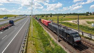
The keystone of Arcerion is the Arco National Railway Service (ANRS). Founded shortly after economic independence from Carna, the ANRS serves as the lifeline for much of the country's rural communities for the efficient transportation of goods and services. The ANRS is also one of the largest employers in the Arco public sector, and with dozens of rail lines operating across all four governates, it is a critical piece of infrastructure. Within cities, the ANRS has several smaller, governate-specific or province/city-specific rail lines including light rail systems for commuting, although these are usually prevalent in more affluent cities such as Kurst or Kinnaird. The ANRS itself is managed by the Ministry of the Interior, under the Department of Infrastructure. Maintenance of rail lines and engines is one of the largest sectors of the Department's budget, surpassing road maintenance year-on-year.
The road networks in Arcerion are classified into three categories, Federal Highway Systems (the Transnational), governate highways and thoroughfares, and local streets or surface roads. In general, the federal government maintains the Transnational which connects all the major governate cities, and is again politically managed by the Department of Infrastructure. Governate highways are usually dependent on the governate respectively, with roads in Northlea for example being better maintained closer to the capital than in the rural Northern stretches. Individual provinces within the governates also have a difficult time repairing roads during the North's harsher winter, with snow clearance and removal services being a provincial responsibility.
For air travel, most major cities boast large airports, the three largest being in Kurst, Kinnaird and Easthampton. The national airline, Air Arco operates a number of domestic flights to connect the medium-sized airports, from the smallest airport on Foxhey to the most Northern in Northlea. Additionally, it also provides intra-Crona flights regularly through Kurst and Kinnaird, with travellers being able to reach destinations in neighbouring countries or across the Malentine/Songun seas. Internationally, Air Arco services flights to Burgundie, Kiravia, and Urcea regularly.
Government and Politics
The government of Arcerion has consistently evolved since its founding as an Ardmori colony in 1790, shifting from a Crown-controlled settlement to a semi-governed entity, and following the Ardmori Civil War and the dissolution of the Crown Regent and the Royal Family of Ardmore as a sovereign, independent nation. Arcerion's government can best be described as a republic, although the inner workings and governmental authority exercised by the executive often can be compared to the power of the Ardmori Crown.
Constitution
Main Article: Constitution of Arcerion
The Arcer constitution is the governing article that dictates how the confederated provinces of Arcerion are to be governed under the rule of law and what outlines Arcerion's sovereignty as a political body. The constitution is a collection of three documents that outline how the Arcer government is to be structured (into three separate branches, the executive, legislative, and the judiciary) as well as the sovereign grounds for the Arcer claim to the large tracts of the Southeastern Cronan peninsula that it occupies.
Ardmori Crown in Absentia
The Arcer government since the dissolution of the Ardmori Royal Family at the end of the Ardmori Civil War has acted as the Ardmori Crown in Absentia. In this role, Arcer Senate, with a super majority vote, retains the vested power of the Crown Regent and are able to make constitutional changes or enact Royal Decrees that affect the Arcer government and the State. This is not used often - since 2000 it has only been exercised twice, both times during states of national emergency to give the Prime Minister's Office extra powers and authority to ensure the survival of the Arco state. The physical Ardmori Crown worn by generations of Kings and Queens of Ardmore is held in the Arco National Archives, where it was recovered during the Civil War by members of the Royal Arcerion Regiment.
The Crown-in-Absentia creates a complicated foreign relationship with the modern day Ardmore, as by proxy this means Arcerion unofficially recognizes that the Crown Regency of Ardmore still has authority and sovereignty over the Ardmori isles, and this is reflected due to Arcerion not maintaining a diplomatic presence in the island nation. It refers to modern day Ardmore as 'The Occupied Islands of the Kingdom.'
Confederate Parliament
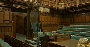
The Confederate Parliament is the Lower House and main legislative body of Arcerion. It is elected during regular federal elections every 4-5 years, and one Member of Parliament is elected from each federal electoral riding, usually based around counties, districts of major cities, or geographical areas. The Confederate Parliament was named as it amalgamated the Parliament of Norham with the Parliament of Moorden, at the time the two governing legislatures of the Arco governorates. They both ratified to confederate into a singular legislative house in Kurst, creating the genesis for the Confederate Parliament. Successive Governorates have each ratified to become part of Arcerion, with Foxhey, Northlea, and Howland Governorates following.
The Parliament is comprised of Members of Parliaments organized into two major groups: the party of majority, which forms the basis of the government, cabinet, and nominates a Prime Minister, and the official opposition, which is the party with the second most elected candidates.
Prime Minister
The Prime Minister of Arcerion is an official selected from the party of the majority, or the party with the most elected seats in the Confederate Parliament. The Prime Minister serves as the Head of Government, as the Head of State is still a vested power within the Crown-in-Absentia. The Prime Minister governs Arcerion as its federal executive, outlining national foreign policy strategies, military deployments, budgetary limits, and working with Lieutenant-Governors on domestic policy for each of Arcerion's Governorates. The Prime Minister is selected by their party during the electoral process, and is usually a senior political figure or bureaucrat. The Prime Minister must be an elected official and member of parliament. The Prime Minister is confirmed via the Arcer Senate, which accepts the nomination and ratifies it via a simple majority. Should a Prime Minister fail to be ratified, the party of the majority nominates a successive list of candidates.

Cabinet
The Arcer Cabinet is made up of elected Members of Parliament who serve in their positions as federal Ministers, overseeing portfolios that include different ministries, departments, and offices. The Cabinet members serve an indefinite term that does not exceed their term limit (4-5 years), and it is not unusual for Prime Ministers to make substitutions or changes to Cabinet personnel during their tenure. Politically, the most important positions are the Minister of Defence, Minister of Finance, Foreign Secretary, Minister of the Interior, and the the Deputy Ministers.
The Deputy Ministers are nominally members of cabinet, but serve primarily as close aides and support members to the Prime Minister. In the event a Prime Minister resigns, dies, or is otherwise indisposed, the three deputy ministers form the line of succession for a temporary continuation of the Arcer government until the party of the majority can nominate a new successor to be approved by the Arcer Senate. Deputy Ministers in turn manage a grouping of Cabinet ministers, and while the Prime Minister sets their agenda and policy to be pursued, the Deputy Ministers help with day-to-day coordination in line with federal direction and mandates.
Senate
The Arcer Senate was established in the 20th century after the Ardmori Civil War, to represent the continuation of Ardmori Crown Regency. Senators are appointed via a 2/3rds majority vote of the Confederate Parliament, and serve for a lifetime term or until they resign. The head of the senate retains the historical title of Crown-Governor of Arcerion, and while nominally the Head of State, is only acting in the interim due to the dissolution of the Ardmori Crown. The Senate's primary function is the ratification of Arcer legislation, constitutional revisions, and confirmation of Prime Ministerial and Cabinet nominees.
Administrative divisions
Arcerion is separated into five Governorates, which are rough equivalent to the provinces or internal states of other sovereign nations. Governorates were created to assist with the administration of the new Arcer colony in the early 1800s, and as each gained a level of autonomy, a larger population, and a growing economy, they ratified the articles of the Acer constitution and joined Arcerion. Each Governorate has a Lieutenant-Governor as its head of government, and is responsible for its internal affairs, taxes, security, and policy. Governorates of Arcerion (by date of ratification) include Moorden Governorate, Norham Governorate, Foxhey Governorate, Northlea Governorate, and Howland Governorate. Arcerion also has several special administration zones for large metropolis or other areas where it deems additional federal oversight is required. These include the Kurst Capital Region, which encompasses the city of Kurst as well as adjacent municipalities within the sphere of the nation's capital, the Chester Economic Zone, which includes Chester-on-Moore and its large dock facilities, and finally the Northwestern Border Security Zone (NWBSZ) which is slated to be discontinued as a special administration zone with the cessation of insurgent and terrorist activity by 2030.

Governorates are chiefly methods to oversee non-federal affairs, so while federal programs such as healthcare, defense, and trade are centrally controlled by bureaucrats and politicians in Kurst, the governorates maintain a fairly large level of autonomy in their own areas. Subordinate to each governorate are Counties, which are municipal subdivisions of their respective Governorate and are responsible for local policing, waste removal, road works and repair, schooling as dictated by federal and gubernatorial law, and public programs.
Judiciary
Arcerion has multiple level of courts that regulate crime, punishment, and regulatory functions as mandated by legislation. The first of these is the individual county courts, both civil and criminal. These are superseded by larger courts, usually the Governorate's individual Supreme Courts. The Supreme Court of Arcerion is the third branch of the federal government (along with the Executive and Legislative), and is composed of 12 Justices, each of whom is nominated by the Prime Minister when there is a vacancy, and confirmed via the Senate's Crown-in-Absentia powers.
Foreign Relations

Main Article: Diplomatic Missions of Arcerion Arcerion's Foreign Office, also called the Ministry of Foreign Affairs, manages a number of embassies and consulates that assist Arcer citizens and business abroad, and also represents Arcer interests with foreign governments. Arcer embassies began as consulates and attache offices before Arcer sovereignty, and with the 1890 grant by the Ardmori Crown to Crown Governor Sir William Walter James with semi-sovereignty that Arcerion began formalizing its embassies with Ambassadors and full diplomatic staff.
Arcerion maintains embassies with the three global superpowers Urcea, Caphiria, and Kiravia, as well as its significant partners and allies such as Burgundie, Stenza, and Alstin. Notably, Arcerion only maintains a small consular presence with its Indigenous neighbours, and due to constant tensions throughout the 20th century and into the 21st century has no foreign mission to the Cape.
Demographics
The 2019 national census of Arcerion counted a total number of Arcers and permanent residents at 89.8 million, and expected to grow by 2035 to over 100 million. There is an average population growth in Arcerion of 1-3% a year, depending on yearly immigration quotas and birth rates, but the yearly average since 2000 has been 2.3%. Arcerion does not benefit in its modern state from as much immigration as it did during the 18th and 19th centuries, although there was a large population spike after the end of the Ardmori Civil War, with hundreds of thousands of Ardmori citizens fleeing to Arcerion with the collapse of the Kingdom of Ardmore. Arcerion's population density is considerably lower than its Cronan counterparts and other Occidental nations due to the large amount of rural and low-density acreage in the Arcer Heartland.
Self-reported ethnic origin in the the Confederated Provinces of Arcerion (2022)
Ethnicity
Overall, Arcerion's national ethnic makeup is overwhelmingly Occidental (over 90%). Ethnic Arcers are identified as those people who have been in Arcerion for two or more generations, and generally consider themselves to be naturalized members of Arcer society. Other smaller fractions such as the large Ardmori ethnic group are slowly assimilating into Arcer culture, as a significant part of Arcerion's cultural makeup draws from Ardmori and Ængle influences. Arcerion does maintain a small indigenous population, located mostly closer to the borders with Kelekona and Titechaxha, as well as in the eastern portions of Moorden Governorate near Washakara. These tribespeople are descendents of the numerous Indigenous tribes that were pushed out during the Arcer Bush Wars, and usually are of permanent resident status, as most Indigenous people in Arcerion do not hold citizenship due to animosity against Arcerion, and as a protest against its status as a sovereign state.
Language
Arcerion's history has been mostly comprised of Ænglish-speaking cultures from the Occidental world, and primarily Levantia. While Arcer citizens have developed many distinct accents and culturally distinct dialects within Ænglish, it is still recognizable as Ænglish to non-native speakers. Over 90% of Arcerion speak some form of Ænglish as its primary language, and within the nation nearly 1/3rd have a second language, reflecting Arcerion's immigrant roots. Arcerion's government uses Ænglish as its official language and it is the only mandated language that is taught in schools and legislated. In some rural parts of Arcerion, Gaelic is still spoken daily, although the amount of Arcers that are monolingual Gaels is less than 1.5%. Indigenous languages are spoken by the Indigenous permanent residents, and there is a wide variety spoken between the Washakaran Basin and the Kelekonese Border area.
Religion
Education
The education system in Arcerion is has multiple mandates and pieces of legislation that help focus studies on what is in the best national interest. Arcer education is similar to many other Occidental systems in that it incorporates the K-12 system for classifying school progression. Schools are organized and administered by each individual Governorate, but regulated via the Department of Education in the Ministry of the Interior. Arcerion has an average literacy rate of 97% or higher, the highest for the region due to low literacy and education rates amongst its northern neighbours. Arcer schools have a high graduation rate, with 95% of Arcer boys and girls graduating from 12th grade to attain a secondary education. Additionally, 23% of Arcer young adults go on to university-level post-secondary education, and 31% into college education programs. As of 2026, Arcerion ranks as the most educated nation in mainland Crona, and Arcer universities ranked highly internationally, with Ardmori Anglican University ranked 8th in a 2024 international study of modern post-secondary school programs for STEM and business.
Culture and Society
Arcer Culture
Arcer society and culture is largely influenced by Ardmori island culture, as well as influences from Levantine Ængles and Gaels. As a nation of immigrants, Arcerion is generally considered to be a 'melting pot' of different cultural, ethnic, and social backgrounds. While early on in its history Arcerion had social classes well defined by the Ardmori peerage system, these slowly were either disregarded or dismantled, and the idea of landed gentry and landowners were replaced with the communal spirit of settling the Arco frontier. Arcer culture largely revolves around a series of social norms based upon Arco Determinism, which is the governing social ethos and comunal memory of the Arco nation.
Cultural traditions in Arcerion drawn from Ardmori islander culture include a reverence for fishermen and maritime activities such as sailing, as well as other subsets such as pub culture and rugby. Gaelic influences can be seen in the Highland culture and usage of bagpipes, kilts, and tartan fabrics in modern Arcer cultures, as many organizations, sports clubs, government offices, and businesses use tartan fabric or have affiliations with traditional Gaelic symbology.
In Arcerion's military, the Regimental System, first adopted from Ardmore, as well as the rank structure, formal titles, and overall organization of the Armed Forces retains much of its original Royal roots.
Arco Determinism
Main Article: Arco Determinism
Arco Determinism, also known as Frontier Spirit, is the governing political and cultural philosophy of Arcer citizens, a group of Cronan-naturalized Carnish and Gaelic peoples who arrived between the 18th and 20th centuries to Southern Crona. The central ideology of Arcerion is a cultural and societal belief that the Arcer people (of the two major migratory groups during the colonial era) are destined to settle, civilize, and create a modern Occidental state in Crona. Concurrent to this, it is a common goal of the society and culture to defend Arcerion and its people, and by extension extend the rule of the Carnish Crown. It also represents a common ethnic and cultural heritage from AEngles, Gaels, and Carnish peoples on values such as community, the family compact, and self-reliance.
Sport
Cuisine
Religion
Arts and Literature
Music
Military and National Defense
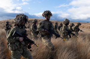
The Armed Forces of Arcerion are one of the key pillars of the nation. The nation's reverence for the role that the military and security forces plays is noted in the numerous holidays, cultural events, and monuments throughout Arcerion. The Armed Forces are structured as a conventional, modern professional force built upon a basis of volunteers serving both full and part time obligations. The Armed Forces have approximately 1.4 million personnel, with the majority of those being in the Reserve Component on a part-time call-up basis. It has four main branches, those being the Arcer Army, Arcer Air Force, Royal Arcerion Naval Service, and the Arcerion Special Operations Command. The Armed Forces maintain a large footprint in Arcerion, with most major military installations being in the Arcer Heartland, and smaller garrisons and staff facilities in the major urban centres. It has participated in a number of major conflicts, such as the Arcer Bush Wars, the Ardmori Civil War, both the First and Second Great Wars, and the Final War of the Deluge.


