Peshabiwar colony: Difference between revisions
Jump to navigation
Jump to search
mNo edit summary |
mNo edit summary Tag: 2017 source edit |
||
| Line 20: | Line 20: | ||
|other_symbol_type = | |other_symbol_type = | ||
|other_symbol = | |other_symbol = | ||
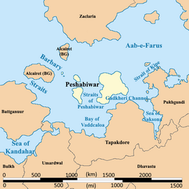
|image_map = | |image_map = Peshabiwar political map.png | ||
|loctext = | |loctext = | ||
|alt_map = <!--alt text for map--> | |alt_map = <!--alt text for map--> | ||
| Line 30: | Line 30: | ||
|capital = | |capital = | ||
|coordinates = <!-- Coordinates for capital, using {{tl|coord}} --> | |coordinates = <!-- Coordinates for capital, using {{tl|coord}} --> | ||
|largest_city = | |largest_city = Gaskheri | ||
|largest_settlement_type = largest city | |largest_settlement_type = largest city | ||
|largest_settlement = Tijah | |largest_settlement = Tijah | ||
Revision as of 16:55, 18 October 2023
This article is a work-in-progress because it is incomplete and pending further input from an author. Note: The contents of this article are not considered canonical and may be inaccurate. Please comment on this article's talk page to share your input, comments and questions. |
Confederated States of Peshabiwar | |
|---|---|
|
Flag | |
 Location of Peshabiwar | |
| Largest largest city | Gaskheri |
| Official languages | Peshbi, Burgoignesc |
| Demonym(s) | Peshbi |
| Government | Republic |
| Establishment | |
• Independence | 1811 |
| Area | |
• Total | 426,079 km2 (164,510 sq mi) |
| Population | |
• 2028 estimate | 3,540,580 |
• Density | 8.3/km2 (21.5/sq mi) |
| GDP (nominal) | estimate |
• Total | $25.5 billion |
• Per capita | $7,200.32 |
| Currency | Common Middle Sea Florin (CMS ƒ) |
| Driving side | right side |
Peshabiwar, officially the Confederated States of Peshabiwar, is a country in Audonia. It is neighbored by Tapakdore and Umardwal.
