Umardwal: Difference between revisions
Tag: 2017 source edit |
mNo edit summary Tag: 2017 source edit |
||
| Line 46: | Line 46: | ||
|established_date1 = A | |established_date1 = A | ||
|area_rank = | |area_rank = | ||
|area = | |area = | ||
|area_km2 = 1140993.36 | |||
|area_sq_mi = 440540 | |||
|area_footnote = <!--Optional footnote for area--> | |||
|percent_water = | |||
|area_label = Total | |||
|area_label2 = <!--Label below area_label (optional)--> | |||
|area_data2 = <!--Text after area_label2 (optional)--> | |||
|population_estimate = 75,889,290 | |population_estimate = 75,889,290 | ||
|population_estimate_rank = | |||
|population_estimate_year = | |||
|population_census = | |population_census = | ||
|GDP_nominal = $ | |population_census_year = [[2030]] | ||
|population_density_km2 = 66.511 | |||
|population_density_sq_mi = 172.264 | |||
|population_density_rank = | |||
|nummembers = <!--An alternative to population for micronation--> | |||
|GDP_PPP = <!--(Gross Domestic Product from Purchasing Power Parity)--> | |||
|GDP_PPP_rank = | |||
|GDP_PPP_year = | |||
|GDP_PPP_per_capita = | |||
|GDP_PPP_per_capita_rank = | |||
|GDP_nominal = $989,932,531,154.70 | |||
|GDP_nominal_rank = | |||
|GDP_nominal_year = | |||
|GDP_nominal_per_capita = $13,044.43 | |GDP_nominal_per_capita = $13,044.43 | ||
|GDP_nominal_per_capita_rank = | |||
|currency = Umardian Rupee | |currency = Umardian Rupee | ||
|currency_code = ɹ | |currency_code = ɹ | ||
| Line 60: | Line 82: | ||
}} | }} | ||
'''Umardwal''', officially the '''Islamic Republic of Umardwal''', is a country in western [[Audonia#Daria|Daria]], the southeastern island of [[Audonia]]. It is a mid-sized country, covering | '''Umardwal''', officially the '''Islamic Republic of Umardwal''', is a country in western [[Audonia#Daria|Daria]], the southeastern island of [[Audonia]]. It is a mid-sized country, covering 1,140,993.36 sqkm, making it one of the largest countries in [[Audonia]]. It is neighbored by [[Peshabiwar]], Dhavastu, and Pukhtunistan to the east, [[Yanuban]] to the south, and [[Pursat]], [[Bulkh]] and [[Battganuur]] to the west. The country shares the [[Sea of Kandahar]] with Battganuur and Pursat. It also contains coastline with the [[Aab-e-Farus|Sea of Aab-e-Farus]]. The majority of Umardwal's 75 million residents live in the northern regions of the country. Most of the terrain in the south consists of arid desert, lowland, steppe, and mountains. Umardwal's capital and largest city is Asrabad, situated along the coast of the Sea of Kandahar; other major cities in Umardwal include Sayyad, Aridia, and Qayalla. | ||
It came to its modern iteration after the Islamic Rising, in 1964 politically, but has maintained its borders due to being the [[Burgoignesc Colonial Empire|Burgoignesc colony]] of the Umardi Presidency. Umardwal is a theocracy with consociational representation, shared between tribal and familial lines. While suffrage is universal and by secret ballot, it is still common for voters to generally follow their tribal leaders lead on issues. Umardwal is a member of the League of Nations, the International Red Cross and Red Crescent Movement. | It came to its modern iteration after the Islamic Rising, in 1964 politically, but has maintained its borders due to being the [[Burgoignesc Colonial Empire|Burgoignesc colony]] of the Umardi Presidency. Umardwal is a theocracy with consociational representation, shared between tribal and familial lines. While suffrage is universal and by secret ballot, it is still common for voters to generally follow their tribal leaders lead on issues. Umardwal is a member of the League of Nations, the International Red Cross and Red Crescent Movement. | ||
Revision as of 15:08, 9 February 2024
| This article is a stub. You can help IxWiki by expanding it. |
Islamic Republic of Umardwal | |
|---|---|
|
Flag | |
Motto: والله زمان يا سلاحي It has been a long time, oh my weapon! | |
Anthem: | |
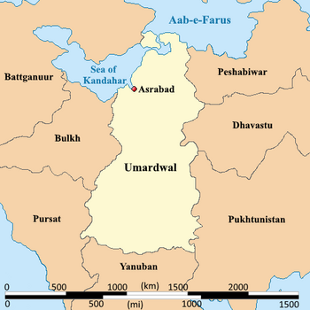
 Map of Umardwal | |
| Capital and largest city | Asrabad |
| Official languages | Arabic Umardi |
| Ethnic groups | Kurdish in the south and Afghan in the north |
| Religion | Shia Islam |
| Demonym(s) | Umardi (noun) Umardian (adjective) |
| Government | Theocracy |
| Fener Jîlwan | |
• President | Rojdar Hewaxan |
| Legislature | National Consultative Assembly |
• | A |
| Area | |
• Total | 1,140,993.36 km2 (440,540.00 sq mi) |
| Population | |
• Estimate | 75,889,290 |
• Density | 66.511/km2 (172.3/sq mi) |
| GDP (nominal) | estimate |
• Total | $989,932,531,154.70 |
• Per capita | $13,044.43 |
| Currency | Umardian Rupee (ɹ) |
| Driving side | right |
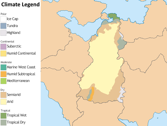
Umardwal, officially the Islamic Republic of Umardwal, is a country in western Daria, the southeastern island of Audonia. It is a mid-sized country, covering 1,140,993.36 sqkm, making it one of the largest countries in Audonia. It is neighbored by Peshabiwar, Dhavastu, and Pukhtunistan to the east, Yanuban to the south, and Pursat, Bulkh and Battganuur to the west. The country shares the Sea of Kandahar with Battganuur and Pursat. It also contains coastline with the Sea of Aab-e-Farus. The majority of Umardwal's 75 million residents live in the northern regions of the country. Most of the terrain in the south consists of arid desert, lowland, steppe, and mountains. Umardwal's capital and largest city is Asrabad, situated along the coast of the Sea of Kandahar; other major cities in Umardwal include Sayyad, Aridia, and Qayalla.
It came to its modern iteration after the Islamic Rising, in 1964 politically, but has maintained its borders due to being the Burgoignesc colony of the Umardi Presidency. Umardwal is a theocracy with consociational representation, shared between tribal and familial lines. While suffrage is universal and by secret ballot, it is still common for voters to generally follow their tribal leaders lead on issues. Umardwal is a member of the League of Nations, the International Red Cross and Red Crescent Movement.
Many scholars have criticized its governance and politics, arguing that it is merely a client of Burgundie.
Etymology
History
Prehistory
Oduniyyad Caliphate
Colonization
Modern-day period
Geography
Climate

Biodiversity
Government
Economy
Its primary exports are crude oil, plastics, iron and steel, and fruit and nuts. It maintains a capitalist economy but with certain controls and subsidies around critical industries like food, water, energy, healthcare, and transportation, which are typically managed as a public-private ventures.
Infrastructure
Roads and rail
Louage
A louage is a minibus shared taxi in many parts of Daria that were colonized by Burgundie. In Burgoignesc, the name means "rental." Departing only when filled with passengers not at specific times, they can be hired at stations. Louage ply set routes, and fares are set by the government. In contrast to other share taxis in Audonia, louage are sparsely decorated. Louages use a color-coding system to show customers what type of transport they provide and the destination of the vehicle. Louages with red lettering travel from one state to another, blue travel from city to city within a state, and yellow serves rural locales. Fares are purchased from ticket agents who walk throughout the louage stations or stands. Typical vehicles include: the MILCAR Jornalero, the TerreRaubeuer Valliant 130, and the CTC M237-07.