Battganuur
| This article is a stub. You can help IxWiki by expanding it. |
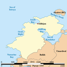
Battganuur is an industrialized and modern nation in western Audonia, stratling the coasts of the eastern Sea of Istroya, the southern coast of the Barbary Strait, the western coast of the Sea of Kandahar, with a small land boarder with Umardwal in the north east, and a long southeastern border with Bulkh. Its coastal areas are heavily urbanized with its interior being largely rural.
Republic of Battganuur | |
|---|---|
|
Flag | |
 Location of Battganuur (dark green) | |
| Capital and largest city | Alihijan |
| Official languages Recognised minority languages | Umardi, Burgoignesc |
| Demonym(s) | Battganuuri |
| Government | |
• Chief of Ministers | Faisal-Jallal Asayesh Aslani |
| Population | |
• 2025 estimate | 104,504,300 |
| GDP (nominal) | 1,915,772,827,600 estimate |
• Per capita | 18,332 |
| Time zone | UTC- |
Battganuur has a bicameral legislature, a supreme court, and an executive, the Chief of Ministers who acts in the same capacity as a president.
It is a member of the League of Nations, the International Red Cross and Red Crescent Movement, and many other international organizations.
It is a market economy focused on exports, under the watchful eye of Burgundie whose companies have a massive stake in the country's economic activity. It specializes in the assembly of microprocessors and cellphones, as well as the cultivation of tropical hard woods, fishing, and rubber, which also constitutes its major exports. It is an active leader in the Middle seas region's economic activity.
Many scholars have criticized its economic governance and politics, arguing that it is merely a client of the Burgoignesc thalattocracy's economic and cultural might.
The people of Battganuur are predominantly culturally Persian, speak Umardi, and most practice Shia Islam.
Demographics
Linguistic Demographics
Religious Demographics
History
Prehistory
Battganuur was originally settled by Indo-Aryan peoples who likewise settled areas from Zaclaria to Pukhgundi. These people shared languages with common roots, the Indo-Aryan languages which later diverged into Proto-Umardonian (west of the Sindhus River) and proto-Sindhus (east of the Sindhus River).
Umaronid Empire
Classical Antiquity
Kingdom of Eshel
~500BC-1486
Arunid Empire
Istroyan city states
Ashrafinid Empire
Audonian Christianity Ruled most of Battganuur and the Alcairet. The aristocracy refused to convert to Islam and were eventually pushed out and some emirated to Levantia to form Hištanšahr
Golden Age
Main article: Oduniyyad Caliphate Denoted as starting with the Muhammadian conquest of the city of Ramsakhs in 670s and ending at the fall of the Oduniyyad Caliphate in 1517, the Golden Age of Audonia had a sweeping effect on the area of modern Battganuur. When it was conquered by the Oduniyyad Caliphate in the 700 and 800s the area was generally already very developed and it took a lot of time and effort to convert the area to Islam.
Early modern era
Starting with the fall of the Oduniyyad Caliphate in 1517 and lasting until the expulsion of the Marialanii Ularien Trading Company in 1836 and the Bourgondii Royal Trading Company in 1842, the early modern era in Battganuur was characterized by rapid development, and unprecedented resource and human exploitation.
Istroya Oriental colony
Colony of the Duchy of Martilles: 1611-1795
Barbary Straits colony
Colony of the Duchy of Marialanus: 1577-1876
Geography
Climate and environment
The tradewinds bring moisture from the Aab-e-Farus and the Sea of Kandahar to the northern interior of Battganuur. In the nation's coast picks up residual moisture from the Sea of Istroya but the tradewinds keep it from having a sever rainy season. The southern third of the country is dominated by the Great Kavir. The prevailing winds pushing moisture off of the Sea of Kandahar keeps the northern portion of the southern third semi-arid.
Economy
Standard of living
Employment
Tourism
Agriculture
Agrinergie
Main article: Agrivoltaics
Logging/Mineral extraction
Paper milling
Mining
Drilling
Fishing
Deep Sea Fishing
Fishing on the Kandahar
Aquaculture
Main article: Aquaculture Aquatic life farming, in general
- Pisciculture- fish farming
- Mariculture- Saltwater fish farming
- shrimp farming
- oyster farming
- algaculture
Manufacturing
Nuradaj MILCAR plant
In 2015, MILCAR opened a plant in Nuradaj, Battganuur. This plant builds the passenger variant Jornaleros used by many louage services in the Daria region of Audonia. They plant also includes repair facilities to maintain the buses they build. The plant employees about 1,000 people as is intentionally unautomated as a way to provide employment opportunities. Due to the wage differential between Pelaxia and Battganuur the plant is still profitable for the Pelaxian company.
Infrastructure
Maritime
Roads and rail
Louage
A louage is a minibus shared taxi in many parts of Daria that were colonized by Burgundie. In Burgoignesc, the name means "rental." Departing only when filled with passengers not at specific times, they can be hired at stations. Louage ply set routes, and fares are set by the government. In contrast to other share taxis in Audonia, louage are sparsely decorated. Louages use a color-coding system to show customers what type of transport they provide and the destination of the vehicle. Louages with red lettering travel from one state to another, blue travel from city to city within a state, and yellow serves rural locales. Fares are purchased from ticket agents who walk throughout the louage stations or stands. Typical vehicles include: the MILCAR Jornalero, the TerreRaubeuer Valliant 130, and the CTC M237-07.