Pukhgundi: Difference between revisions
Tags: Mobile edit Mobile web edit Advanced mobile edit |
m (→Demographics) Tag: 2017 source edit |
||
| (14 intermediate revisions by the same user not shown) | |||
| Line 65: | Line 65: | ||
|area_rank = | |area_rank = | ||
|area = | |area = | ||
|area_km2 = | |area_km2 = 387669.42 | ||
|area_sq_mi = | |area_sq_mi = 149680 | ||
|area_footnote = <!--Optional footnote for area--> | |area_footnote = <!--Optional footnote for area--> | ||
|percent_water = | |percent_water = | ||
| Line 74: | Line 74: | ||
|population_estimate = 42,600,400 | |population_estimate = 42,600,400 | ||
|population_estimate_rank = | |population_estimate_rank = | ||
|population_estimate_year = | |population_estimate_year = | ||
|population_census = | |population_census = | ||
|population_census_year = | |population_census_year = [[2030]] | ||
|population_density_km2 = | |population_density_km2 = 109.888 | ||
|population_density_sq_mi = | |population_density_sq_mi = 284.609 | ||
|population_density_rank = | |population_density_rank = | ||
|nummembers = <!--An alternative to population for micronation--> | |nummembers = <!--An alternative to population for micronation--> | ||
| Line 86: | Line 86: | ||
|GDP_PPP_per_capita = | |GDP_PPP_per_capita = | ||
|GDP_PPP_per_capita_rank = | |GDP_PPP_per_capita_rank = | ||
|GDP_nominal = | |GDP_nominal = $907,558,921,600 | ||
|GDP_nominal_rank = | |GDP_nominal_rank = | ||
|GDP_nominal_year = | |GDP_nominal_year = | ||
|GDP_nominal_per_capita = | |GDP_nominal_per_capita = $21,304 | ||
|GDP_nominal_per_capita_rank = | |GDP_nominal_per_capita_rank = | ||
|Gini = | |Gini = | ||
| Line 117: | Line 117: | ||
The people of Pukhgundi are predominantly culturally {{wp|Khas people|Pukhti Gorkha}}, speak {{wp|Nepalese language|Pukhti}} , and most practice {{wpl|Hinduism}}. | The people of Pukhgundi are predominantly culturally {{wp|Khas people|Pukhti Gorkha}}, speak {{wp|Nepalese language|Pukhti}} , and most practice {{wpl|Hinduism}}. | ||
==Demographics== | |||
{{Pie chart | |||
| radius = 100 | |||
| thumb =right | |||
| caption = Self-reported ethnic origin in Tapakdore (2030) | |||
| other = | |||
| label1 = {{wp|Nepali}} | |||
| value1 =63.4 | |||
| color1 =#4F7942 | |||
| label2 = {{wp|Tamils}} | |||
| value2 =14.2 | |||
| color2 =#8FBC8F | |||
| label3 = [[Ebidi]] | |||
| value3 =7 | |||
| color3 =#9FA91F | |||
| label4 = [[Occidental]] | |||
| value4 =2.9 | |||
| color4 =#960018 | |||
| label5 = other/multi-ethnic | |||
| value5 =12.5 | |||
| color5 =Blue | |||
}} | |||
<gallery mode="packed"> | |||
File:Nepali Singer Purna Nepali.jpg | |||
File:Rekha thapa and kuber giri.jpg | |||
File:Nepal (322114992).jpg | |||
File:Rekha thapa(2).jpg | |||
File:Nepal (291971615).jpg | |||
File:Nepal (308557671).jpg | |||
File:Shital Niwas Ram Baran Yadav, Uttam Nepali, Geeta Tripathee.jpg | |||
</gallery> | |||
==History== | ==History== | ||
| Line 125: | Line 158: | ||
Tea, silk, teak plantations | Tea, silk, teak plantations | ||
==Climate== | ==Geography== | ||
<gallery mode="packed"> | |||
File:Urpad beel.jpg | |||
File:Sunset view point, Nisangram village.jpg | |||
File:Assam tea garden view.jpeg | |||
</gallery> | |||
===Climate=== | |||
{{Further|Prevailing Winds}} | |||
[[File:Pukhgundi climate map.png|center|Thumb|Climate map of Pukhgundi.]] | [[File:Pukhgundi climate map.png|center|Thumb|Climate map of Pukhgundi.]] | ||
| Line 134: | Line 174: | ||
===Agriculture=== | ===Agriculture=== | ||
[[File:Wet rice paddy fields in Dibrugarh district, Assam, NE India.jpg|200px|right]] | |||
{{wp|Basmati rice}}, {{wp|rapeseed}}, {{wp|mustard seed}}, {{wp|jute}}, {{wp|potato}}, {{wp|sweet potato}}, {{wp|banana}}, {{wp|papaya}}, {{wp|areca nut}}, {{wp|sugarcane}}, and {{wp|turmeric}}. | {{wp|Basmati rice}}, {{wp|rapeseed}}, {{wp|mustard seed}}, {{wp|jute}}, {{wp|potato}}, {{wp|sweet potato}}, {{wp|banana}}, {{wp|papaya}}, {{wp|areca nut}}, {{wp|sugarcane}}, and {{wp|turmeric}}. | ||
====Tea==== | ====Tea==== | ||
[[File:Tea garden of Assam.jpg|200px|right]] | |||
[[File:People working at tea garden 001.jpg|200px|right]] | |||
{{wp|Assam tea}} | {{wp|Assam tea}} | ||
| Line 168: | Line 211: | ||
===Infrastructure=== | ===Infrastructure=== | ||
<gallery mode="packed"> | |||
File:Koliabhomora Setu.jpg | |||
</gallery> | |||
====Maritime==== | ====Maritime==== | ||
==== | ====Rail==== | ||
Pukhgundi uses [[Track gauges around the world|Standard gauge]], 1,435 mm (4 ft 8+1⁄2 in) as most of its rail infrastructure has been under the auspices of [[Burgundie]] and its sphere of influence in the [[Middle seas region]], who all use that rail gauge. | |||
====Roads==== | |||
[[File:Taxi in Assam Guwahati IMG 3855.jpg|200px|right]] | |||
=====Louage===== | |||
A '''louage''' is a minibus shared taxi in many parts of [[Daria]] that were [[Burgoignesc colonial empire|colonized]] by [[Burgundie]]. In [[Burgoignesc language|Burgoignesc]], the name means "rental." Departing only when filled with passengers not at specific times, they can be hired at stations. Louage ply set routes, and fares are set by the government. In contrast to other share taxis in [[Audonia]], louage are sparsely decorated. Louages use a color-coding system to show customers what type of transport they provide and the destination of the vehicle. Louages with red lettering travel from one state to another, blue travel from city to city within a state, and yellow serves rural locales. Fares are purchased from ticket agents who walk throughout the louage stations or stands. Typical vehicles include: the [[MILCAR#Trucks|MILCAR Jornalero]], the [[TerreRaubeuer_Motor_Car_Company|TerreRaubeuer Valliant 130]], and the [[Cross_Trucking_Company#Industrial_and_Construction|CTC M237-07]]. | |||
====Air==== | ====Air==== | ||
====Energy and electricity==== | ====Energy and electricity==== | ||
Revision as of 22:07, 28 March 2024
| This article is a stub. You can help IxWiki by expanding it. |
Republic of Pukhgundi | |
|---|---|
|
Flag | |
 Location of Pukhgundi | |
| Capital | Sarkar |
| Largest largest city | Tarigar |
| Official languages | Pukhti, Burgoignesc |
| Ethnic groups | Primarily Pukhti Gorkhas |
| Religion | Primarily Hindu |
| Demonym(s) | Pukhgundti |
| Government | Republic |
• President | Nandakishor Mitra |
| Establishment | |
• Independence | 1811 |
| Area | |
• Total | 387,669.42 km2 (149,680.00 sq mi) |
| Population | |
• Estimate | 42,600,400 |
• Density | 109.888/km2 (284.6/sq mi) |
| GDP (nominal) | estimate |
• Total | $907,558,921,600 |
• Per capita | $21,304 |
| Currency | Common Middle Sea Florin (CMS ƒ) |
| Driving side | right side |
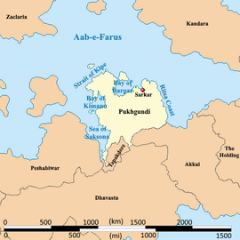
Pukhgundi, officially the Republic of Pukhgundi, is a minor-power sovereign country central in western Audonia. It is bound by the Aab-e-Farus in the north, Tapakdore in the southwest, Dhavastu in the south, Akkai in the southeast, and the Sea of Saksona in the west. It is a constitutional republic with universal suffrage is praised for holding consistently open and fair elections in the Region.
It is a member of the League of Nations, the International Red Cross and Red Crescent Movement, and many other international organizations. It is a emerging market, market economy focused on exports, under the watchful eye of Burgundie whose companies have a massive stake in the country's economic activity. It is an active member in the Middle seas region's economic activity. Many scholars have criticized its economic governance and politics, arguing that it is merely a client of the Burgoignesc thalattocracy's economic and cultural might.
The people of Pukhgundi are predominantly culturally Pukhti Gorkha, speak Pukhti , and most practice Hinduism.
Demographics
Self-reported ethnic origin in Tapakdore (2030)
History
Pukhgundi colony
Tea, silk, teak plantations
Geography
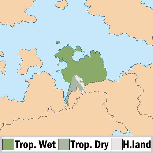
Climate

Economy
Employment
Textiles
Fertilizer production
Agriculture

Basmati rice, rapeseed, mustard seed, jute, potato, sweet potato, banana, papaya, areca nut, sugarcane, and turmeric.
Tea


Silk
Tourism
Agrinergie
Main article: Agrivoltaics
Logging/Mineral extraction
Mining
Drilling
Fishing
Aquaculture
Main article: Aquaculture Aquatic life farming, in general
- Pisciculture- fish farming
- Mariculture- Saltwater fish farming
- shrimp farming
- oyster farming
- algaculture
Trade
Transshipment
Main article: Transshipment
Customs and tariffs
Main article: Customs
Infrastructure
Maritime
Rail
Pukhgundi uses Standard gauge, 1,435 mm (4 ft 8+1⁄2 in) as most of its rail infrastructure has been under the auspices of Burgundie and its sphere of influence in the Middle seas region, who all use that rail gauge.
Roads

Louage
A louage is a minibus shared taxi in many parts of Daria that were colonized by Burgundie. In Burgoignesc, the name means "rental." Departing only when filled with passengers not at specific times, they can be hired at stations. Louage ply set routes, and fares are set by the government. In contrast to other share taxis in Audonia, louage are sparsely decorated. Louages use a color-coding system to show customers what type of transport they provide and the destination of the vehicle. Louages with red lettering travel from one state to another, blue travel from city to city within a state, and yellow serves rural locales. Fares are purchased from ticket agents who walk throughout the louage stations or stands. Typical vehicles include: the MILCAR Jornalero, the TerreRaubeuer Valliant 130, and the CTC M237-07.


