Pursat: Difference between revisions
m (→History) |
m (→See also) Tag: 2017 source edit |
||
| (53 intermediate revisions by 2 users not shown) | |||
| Line 1: | Line 1: | ||
{{ | {{stub}} | ||
= | {{Infobox country|native_name = <!--e.g. France--> Pursat | ||
=== | |conventional_long_name = Muwahhidnn State of Pursat | ||
====[[ | |common_name = | ||
[[ | |image_flag = Flag of the State of Souaida (state).svg | ||
|alt_flag = | |||
|image_coat = <!--* e.g. Coat of arms of country.svg--> | |||
|alt_coat = <!--alt text for coat of arms--> | |||
|symbol_type = <!--emblem/seal/... based on image_coat--> | |||
|national_motto = <!--"[[motto]]"--> Freedom at last | |||
|national_anthem = | |||
|royal_anthem = <!--''[[name of/link to anthem]]''--> | |||
|other_symbol_type = The Great Fort | |||
|other_symbol = [[File:Ark_fortress_in_Bukhara.jpg|250px]] | |||
|image_map = PursatPoliticalMap.png | |||
|alt_map = | |||
|map_caption = Map of Pursat | |||
|image_map2 = | |||
|alt_map2 = <!--alt text for second map--> | |||
|map_caption2 = <!--Caption to place below second map--> | |||
|capital = Mharran | |||
|latd= | latm= | latNS = <!--capital's latitude degree/min/dir--> | |||
|longd= |longm= |longEW = <!--capital's longitude deg/min/dir--> | |||
|largest_city = Mharran | |||
|largest_settlement = <!--(if not a city)--> | |||
|largest_settlement_type = <!--Type of settlement if largest settlement not a city--> | |||
|official_languages = <!--e.g. English, French--> | |||
|national_languages = <!--Officially recognized national languages--> | |||
|regional_languages = <!--Officially recognized regional languages--> | |||
|languages_type = <!--Other type of languages --> {{wpl|Kalmyk_Oirat|Pursi}}, [[Burgoignesc language|Burgoignesc]] | |||
|languages = Aramaic, Arabic | |||
|ethnic_groups = Druze | |||
|ethnic_groups_year = | |||
|demonym = Pursatnieen | |||
|government_type = Theocracy | |||
|leader_title1 = Sheikh-in-Chief | |||
|leader_name1 = | |||
|leader_title2 = | |||
|leader_name2 = | |||
|sovereignty_type = | |||
|sovereignty_note = | |||
|established_event1 = Independence from the [[Burgoignesc North Levantine Trading Company|MNLC]] | |||
|established_date1 = [[1822]] | |||
|established_event2 = | |||
|established_date2 = | |||
|established_event3 = | |||
|established_date3 = | |||
|established_event4 = | |||
|established_date4 = | |||
|established_event5 = | |||
|established_date5 = | |||
|established_event6 = | |||
|established_date6 = | |||
|area_rank = | |||
|area_magnitude = | |||
|area = <!-- major area size (in [[Template:convert]] either km2 or sqmi first) --> () | |||
|area_km2 = <!-- major area size (in square km) --> 610667.397 | |||
|area_sq_mi = 235780 | |||
|area_footnote = <!-- optional footnote for area --> | |||
|percent_water = | |||
|area_label = <!-- label under "Area" (default: Total) --> | |||
|area_label2 = <!-- label below area_label (optional) --> | |||
|area_dabodyalign = <!-- text after area_label2 (optional) --> | |||
|population_estimate = 504,569,500 | |||
|population_estimate_rank = | |||
|population_estimate_year = | |||
|population_census = | |||
|population_census_year = | |||
|population_density_km2 = 826.259 | |||
|population_density_sq_mi = 2,140.001 | |||
|population_density_rank = | |||
|GDP_nominal = $6,358,080,269,500 | |||
|GDP_nominal_per_capita = $12,601 | |||
|Gini = | |||
|Gini_rank = | |||
|Gini_year = | |||
|Gini_change = | |||
|Gini_category = | |||
|HDI = | |||
|HDI_rank = | |||
|HDI_year = | |||
|HDI_change = | |||
|HDI_category = | |||
|currency = [[Taler#Pegged_currencies|Pursatni Taler]] | |||
|currency_code = PT | |||
|time_zone = | |||
|utc_offset = <!-- +N, where N is number of hours--> | |||
|time_zone_DST = | |||
|antipodes = <!-- countries or islands antipodal to this one--> | |||
|date_format = dd-mm-yy | |||
|DST_note = | |||
|utc_offset_DST = <!-- +N, where N is number of hours--> +0 | |||
|drives_on = right side | |||
|cctld = | |||
|iso3166code = P₮ | |||
|calling_code = | |||
|image_map3 = | |||
|alt_map3 = | |||
|footnotes = <!--for any generic non-numbered footnotes--> | |||
|footnote1 = | |||
|footnote2 = | |||
<!-- ... --> | |||
|footnote7 = | |||
}} | |||
Pursat | The ''Muwahhidnn State of Pursat'', often just called Pursat, is a rapidly modernizing nation in southwestern [[Daria]] region of [[Audonia]] bordered by the [[Bay of Oduniyye]] in the west, [[Bulkh]] in the north, [[Umardwal]] and [[Yanuban]] in the east and south. It was massively urbanized in the 1980s and 90s and has a very high population for its landmass. Its executive is a president for life, but it does hold democratic elections for its legislative branch and local offices. | ||
Yanuban is a member of many international organizations like the [[League of Nations]], the {{wpl|ISO}}, Red Crescent International, etc. and many other regulatory and economic bodies. | |||
It is a market economy focused on exports, under the watchful eye of [[Burgundie]], whose companies have a massive stake in the country's economic activity. It specializes in the assembly of microprocessors and cellphones, as well as the cultivation of tropical hard woods, fishing, and rubber, which also constitutes its major exports. | |||
== See | The people of Yanuban are predominantly culturally Arab, speak Arabic, and most practice {{wpl|Sunni Islam}}. | ||
==Etymology== | |||
Pursat is a transliteration of the Aramaic word ''pirsa'' meaning lust with the ''tay merbutah'' the final "t" sound meaning the place listed after. It was referred to as such because of its beautiful landscape and rich resources. It is sometimes referred to as the location of Eden. | |||
==Climate== | |||
{{Further|Prevailing Winds}} | |||
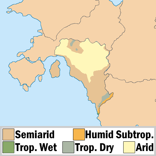
[[File:Pursat climate map.png|center|Thumb|Climate map of Pursat.]] | |||
==Economy== | |||
===Agriculture=== | |||
{{wp|Guar}} and {{wp|guar gum}} | |||
===Infrastructure=== | |||
====Rail==== | |||
Pursat uses [[Track gauges around the world|Standard gauge]], 1,435 mm (4 ft 8+1⁄2 in) as most of its rail infrastructure has been under the auspices of [[Burgundie]] and its sphere of influence in the [[Middle seas region]], who all use that rail gauge. | |||
====Roads==== | |||
=====Louage===== | |||
A '''louage''' is a minibus shared taxi in many parts of [[Daria]] that were [[Burgoignesc colonial empire|colonized]] by [[Burgundie]]. In [[Burgoignesc language|Burgoignesc]], the name means "rental." Departing only when filled with passengers not at specific times, they can be hired at stations. Louage ply set routes, and fares are set by the government. In contrast to other share taxis in [[Audonia]], louage are sparsely decorated. Louages use a color-coding system to show customers what type of transport they provide and the destination of the vehicle. Louages with red lettering travel from one state to another, blue travel from city to city within a state, and yellow serves rural locales. Fares are purchased from ticket agents who walk throughout the louage stations or stands. Typical vehicles include: the [[MILCAR#Trucks|MILCAR Jornalero]], the [[TerreRaubeuer_Motor_Car_Company|TerreRaubeuer Valliant 130]], and the [[Cross_Trucking_Company#Industrial_and_Construction|CTC M237-07]]. | |||
==Culture== | |||
===Sport=== | |||
====Pursatni Pangolins==== | |||
[[File: Pursatni Pangolins.jpg|right|200px|Pursatni Pangolin logo.]] | |||
The national [[WAFF]] league soccer team of Pursat are the Pursatni Pangolins. | |||
== See also == | |||
*[[Burgoignesc thalattocracy#Cultural_usage|Burgoignesc thalattocracy]] | |||
{{Audonia topics}} | |||
[[Category:Audonia]] | |||
[[Category:Countries]] | [[Category:Countries]] | ||
{{ | [[Category: Burgundie]] | ||
[[Category:NPC Countries]] | |||
[[Category: Burgoignesc NPC Countries]] | |||
[[Category:Map Completion Project]] | |||
{{Template:Award winning article}} | |||
[[Category:2023 Award winning pages]] | |||
[[Category:IXWB]] | |||
[[Category:Pursat]] | |||
Latest revision as of 20:41, 19 April 2024
| This article is a stub. You can help IxWiki by expanding it. |
Muwahhidnn State of Pursat Pursat | |
|---|---|
|
Flag | |
Motto: Freedom at last | |
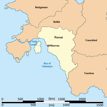
 Map of Pursat | |
| Capital and | Mharran |
| Pursi, Burgoignesc | Aramaic, Arabic |
| Ethnic groups | Druze |
| Demonym(s) | Pursatnieen |
| Government | Theocracy |
| Establishment | |
• Independence from the MNLC | 1822 |
| Area | |
• | 610,667.397 km2 (235,780.000 sq mi) |
| Population | |
• Estimate | 504,569,500 |
• Density | 826.259/km2 (2,140.0/sq mi) |
| GDP (nominal) | estimate |
• Total | $6,358,080,269,500 |
• Per capita | $12,601 |
| Currency | Pursatni Taler (PT) |
• Summer (DST) | UTC+0 |
| Date format | dd-mm-yy |
| Driving side | right side |
| ISO 3166 code' | P₮ |
The Muwahhidnn State of Pursat, often just called Pursat, is a rapidly modernizing nation in southwestern Daria region of Audonia bordered by the Bay of Oduniyye in the west, Bulkh in the north, Umardwal and Yanuban in the east and south. It was massively urbanized in the 1980s and 90s and has a very high population for its landmass. Its executive is a president for life, but it does hold democratic elections for its legislative branch and local offices.
Yanuban is a member of many international organizations like the League of Nations, the ISO, Red Crescent International, etc. and many other regulatory and economic bodies.
It is a market economy focused on exports, under the watchful eye of Burgundie, whose companies have a massive stake in the country's economic activity. It specializes in the assembly of microprocessors and cellphones, as well as the cultivation of tropical hard woods, fishing, and rubber, which also constitutes its major exports.
The people of Yanuban are predominantly culturally Arab, speak Arabic, and most practice Sunni Islam.
Etymology
Pursat is a transliteration of the Aramaic word pirsa meaning lust with the tay merbutah the final "t" sound meaning the place listed after. It was referred to as such because of its beautiful landscape and rich resources. It is sometimes referred to as the location of Eden.
Climate

Economy
Agriculture
Infrastructure
Rail
Pursat uses Standard gauge, 1,435 mm (4 ft 8+1⁄2 in) as most of its rail infrastructure has been under the auspices of Burgundie and its sphere of influence in the Middle seas region, who all use that rail gauge.
Roads
Louage
A louage is a minibus shared taxi in many parts of Daria that were colonized by Burgundie. In Burgoignesc, the name means "rental." Departing only when filled with passengers not at specific times, they can be hired at stations. Louage ply set routes, and fares are set by the government. In contrast to other share taxis in Audonia, louage are sparsely decorated. Louages use a color-coding system to show customers what type of transport they provide and the destination of the vehicle. Louages with red lettering travel from one state to another, blue travel from city to city within a state, and yellow serves rural locales. Fares are purchased from ticket agents who walk throughout the louage stations or stands. Typical vehicles include: the MILCAR Jornalero, the TerreRaubeuer Valliant 130, and the CTC M237-07.
Culture
Sport
Pursatni Pangolins

The national WAFF league soccer team of Pursat are the Pursatni Pangolins.
See also
