Umardwal
This article is a work-in-progress because it is incomplete and pending further input from an author. Note: The contents of this article are not considered canonical and may be inaccurate. Please comment on this article's talk page to share your input, comments and questions. |
Islamic Republic of Umardwal | |
|---|---|
|
Flag | |
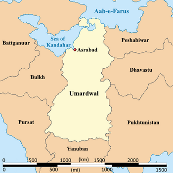
 Map of Umardwal | |
| Capital and largest city | Asrabad |
| Official languages | Arabic Umardi |
| Ethnic groups | Umardi in the south and Ifgeen in the north |
| Religion | Sunni Islam |
| Demonym(s) | Umardi (noun) Umardian (adjective) |
| Government | Theocracy |
| Fener Jîlwan | |
• President | Rojdar Hewaxan |
| Legislature | National Consultative Assembly |
• | A |
| Area | |
• Total | 1,140,993.36 km2 (440,540.00 sq mi) |
| Population | |
• Estimate | 75,889,290 |
• Density | 66.511/km2 (172.3/sq mi) |
| GDP (nominal) | estimate |
• Total | $989,932,531,154.70 |
• Per capita | $13,044.43 |
| Currency | Umardian Rupee (ɹ) |
| Driving side | right |
Umardwal, officially the Islamic Republic of Umardwal, is a newly industrialized country in central Daria, Audonia. It has a land mass of 1,140,993.36 sqkm, making it one of the largest countries in Audonia. It is neighbored by Tapakdore, Dhavastu, and Pukhtunistan to the east, Yanuban to the south, and Pursat, Bulkh and Battganuur to the west. The country shares the Sea of Kandahar with Battganuur and Pursat. It also contains coastline with the Sea of Aab-e-Farus. The majority of Umardwal's 75 million residents live in the northern regions of the country. Most of the terrain in the south consists of arid desert, lowland, steppe, and mountains. Umardwal's capital and largest city is Asrabad, situated along the coast of the Sea of Kandahar; other major cities in Umardwal include Sayyad, Aridia, and Qayalla.
It came to its modern iteration after the Islamic Rising, in 1964 politically, but has maintained its borders due to being the Burgoignesc colony of the Umardi Presidency. Umardwal is a theocracy with consociational representation, shared between tribal and familial lines. While suffrage is universal and by secret ballot, it is still common for voters to generally follow their tribal leaders lead on issues. Umardwal is a member of the League of Nations, the International Red Cross and Red Crescent Movement.
The people of Umardwal are predominantly ethnically Ifgeen, Umardi, Ebidis, and Kashmiris. The lingua franca is Umardi but Ifgigeen is an important regional language in the country's north where the majority of the population live. International affairs and business are typically conducted in Burgoignesc, with approximately 7% of the population, mostly the elites, speaking it with some level of fluency. 77.6% of the population identifies as Muslim, primarily Sunni. However, Druzism is so closely aligned with Muslim societal morays that it is often lumped in and the theocracy states thats their faithful represent over 84% of the population. Christians represent 14.4% of the total with the Marandite Catholic Church and Mercantile Reform Protestantism forming the main denominations. Education, K-12 is mandatory, but most schools are madrasa. As a result, social science topics are often taught through the lens of Islamic education, and are considered the most important subjects, often at the expense of STEM. As a result, despite a high graduation rate of 84% from secondary education, the students produced by this system are not on equal footing with other global counterparts with the same level of academic attainment.
Many scholars have criticized its governance and politics, arguing that it is merely a proxy-puppet of Burgundie.
Society
Self-reported religious affiliation in Umardwal (2030)
The people of Umardwal are predominantly culturally Ifgeen, Umardi, Ebidis, and Kashmiris. The lingua franca is Umardi but Ifgigeen is an important regional language in the country's north where the majority of the population live. International affairs and business are typically conducted in Burgoignesc, with approximately 7% of the population, mostly the elites, speaking it with some level of fluency.
Faith plays a central role in shaping Umardwal's political and social fabric. 77.6% of the population identifies as Muslim, primarily Sunni. However, Druzism is so closely aligned with Muslim societal morays that it is often lumped in and the theocracy states thats their faithful represent over 84% of the population. Christians represent 14.4% of the total with the Marandite Catholic Church and Mercantile Reform Protestantism forming the main denominations. Because the theocracy is based on the Muslim faith the Christians and Druze are particularly vulnerable to political exclusion. Mercantile Reform Protestants, in particular, are subject to a higher-than-average incarceration rates by the Guardians of the Islamic Revolutionary Ideal. However, the state does officially espouse religious tolerance. All government holidays are based around the observance of Muslim holidays, feasts, and fasting.
Impact of the foreign workforce
Umardwal's large foreign workforce has increased the large diaspora of many nationalities, with the majority coming from Tierrador. The Qabóri-Audonian Employment Program was created in 1939 by Woqali Satola Sanleć, and was originally intended as a second-chance program for convicted Tierradorian felons. However, as the program grew, it began to allow any Tierradorian national, regardless of background, to seek overseas employment in Burgoignesc Audonia. Umardwal hosts the most Tierradorian foreign workers out of any country, at 29,000, and the Tierradorian diaspora is very prominent in Umardwal. Tierradorian cuisine has grown in popularity in Umardwal, with many local Poraqal-style restaurants with an Umardi twist being seen throughout the country.
Cuisine
Rice and millet are the staples of Umardi cuisine, which is heavily based on cereal grains. Grains are generally prepared with sauces made from edible leaves, such as spinach or baobab, with tomato peanut sauce, and may be accompanied by pieces of grilled meat (typically chicken, mutton, beef, or goat).
Distribution
80% of the countries 75.8 million people living the northern provinces of Asrabad Capital District, Umdaria, Umalia, Ifgean, and Indukoush. These provinces are where most of the countries cities, ports, and farms are. 54% of the total population live in the coastal cities which have been vitally important to the region since ancient times as trading posts. The Great Kavir divides the country in half and is traversed by nomadic peoples and Bulkhiyeen Bedouins but there are only a few settlements along the Asarmagh River and the Trans-Kavirian Railroad. There are 6 major settlements (over 100k) in the southern part of the country, primarily mining or faming towns in the Baqunah and Mahagheh Mountains: Hewleer, Duhok, Hamawand, Kewa, Jarmo, and Yeziid.
Geography

-
Great Kavir in Umardwal
-
Great Kavir in Umardwal
-
Great Kavir in Umardwal
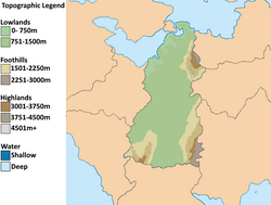
Umardwal is a vast and open plains with massive tropical plains, called the Umalian Plain and Umdari Peninsula, in the far northern third of and the Great Kavir desert covering the southern two thirds. It has three mountainous regions in its northeastern, southwestern, and southeastern border regions, the Indukoush, Baqunah, and Mahagheh Mountains respectively.
The Asarmagh River runs from the southwestern Baqunah Mountains almost the whole length of the country to the Sea of Kandahar. It is a vital agricultural and transportation corridor for the country, but it runs dry in the southern hemispheric summer, December - February due to the extreme heat in the Great Kavir. The Sarayaan River runs from the foothills of the Indukoush Mountains to the Sea of Kandahar, and the Sindhus River from the highlands of the Indukoush Mountains into western Dhavastu.
Climate and environment

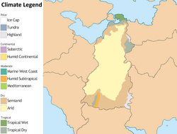
Umardwal is climactically divided into three mega-regions. The northern fertile, tropical Umalian Plain, the central arid Great Kavir desert, and the temperate highlands of the Indukoush, Baqunah, and Mahagheh Mountains.
Battganuur, along with Burgoignesc, Bulkh, and Pursat is working on a largescale greening, rewilding, and de-desertification project to reclaim arable land from the Great Kavir called the Great Green Wall.
History
Prehistory
It's estimated that the first settlements in the modern area of bulk were settled around 15,000 BCE. These settlements were primarily in the interior where the Great Kavir desert is today. Up until 5,000 years ago, the area was not so arid and the vegetation might have been closer to a savanna. However, desertification set in around 3000 BCE, and the desert became much like it is today. This desertification pushed the people further south and north into the Sea of Kandahar basin and the Baqunah, and Mahagheh Mountains by 4500 BCE. The interior had become mostly uninhabited by 500 BCE, and the Sea of Kandahar's and Aab-e-Farus coasts had become the primary areas of both settlement and cultivation of crops. There was still bands of nomads in the desert interior but not nearly to the same extent that there had been two or 3,000 years prior. These northern coastal settlements became more and more settled as the cultivation of rice and millet and the raising of goats and sheep in the tropical Umalian became more sustainable for the larger populations.
Classical Antiquity
Arunid Empire
Medieval period
Oduniyyad Caliphate
Modern Umardwal was a divided into two administrative provinces during the rule of the Caliphate, Umalia in the north, Markhazia in the southern part of Umardwal and the northern part of Yanuban. These provinces were based both on ethnic distinctions with the Ifgeen north of the Great Kavir and the Umardi south of the desert. The province of Umalia was a crowning jewel for the Caliphate with its fertile land, it's booming textile industry and trade routes on Sea of Kandahar and the Aab-e-Farus. It became a hub of learning and culture and served as the crossroads between the Arabo-Persian and the Punjabo-Nepali areas of the Caliphate.
Colonization
Modern-day period
First Great War
Contemporary period
1943-today
The country saw increasing relations with Tierrador following the creation of the Qabóri-Audonian Employment Program. Tierrador had also supplied the country with a large amount of foreign aid, and assisted in reconstruction following Operation Kipling. Now, Tierrador remains a close ally with Umardwal, along with other former Burgoignesc colonies, and both countries regularly exchange foreign workers.
Government and Politics
Umardwal is an Islamic theocracy whose head of state is Ayatollah Fener Jîlwan. President Rojdar Hewaxan is the head of government of the National Consultative Assembly, a role which is largely ceremonial. The state maintains Sharia law but it's interpretation has become much more lax since the Islamic Revolution of 1964. Elections are held every 5 years but sufferage is only available to men over the age of 21 or those over 18 in the armed forces. Umardwal is a one party state but the state puts forward moderate, liberal, and conservative candidates in each district for local governance as a litmus test for the prevailing political attitudes of the populace. Moderates did well, overall in the 1982, 1987, and 1992 elections. In 1997, 2002, and 2007 the liberal candidates did well and the country saw a general openness to foreigners and a lighter touch on the strict adherence to Sharia law. Since the 2012 election their has been a resurgence of conservative candidate victories and the country has taken a stronger stance on self-sufficiency, Burgophobia and Counter-Equatorial Movement, and a stricter adherence of Sharia law.
Subdivisions

- Asrabad Capital District
- Umdaria, capital Sayyad
- Umalia, capital Baab al Kandahar
- Ifgean, capital Qayalla
- Indukoush, capital Khandouz
- Kavir Shamali (Eastern Wasteland (Great Kavir)), capital Baab al Mayranj
- Kavir Markhazi (Central Wasteland (Great Kavir)), capital Herkot
- Baqunah, capital Hamawand
- Mahagheh, capital Kewa
Military
-
Guardians of the Islamic Revolutionary Ideal
-
Guardians of the Islamic Revolutionary Ideal
The Islamic Armed Forces of Umardwal number 1.45 million personnel across all 6 branches:
- Guardians of the Islamic Revolutionary Ideal (gendarmerie): 283,000 paramilitaries
- Army of the Islamic Republic: 849,400
- Islamic Republican Navy: 150,800
- Islamic Republican Air and Missile Forces: 80,700
- Financial Enforcement and Life Saving Services of the Islamic Republic (coast guard): 43,900
- Space and Cyberwarfare Forces: 48,300
Economy
Umardwal has a GDP of almost $1 trillion, making it one of the largest economies out of all the former Burgoignesc colonies in Audonia. Its primary exports are crude oil, plastics, iron and steel, and fruit and nuts. It maintains a capitalist economy but with certain controls and subsidies around critical industries like food, water, energy, healthcare, and transportation, which are typically managed as a public-private ventures. By regional standards, Umardwal possesses a somewhat diversified economy, being a large trade hub for a lot of resources in Daria. However, the country's GDP is still heavily reliant on petroleum exports, and the petroleum and mineral extraction sectors dominate the country's fast-growing economy. There have been many attempts by the Umardi government to diversify the economy even more, subsidizing agriculture, tourism, and even automobile manufacturing. The country has received foreign aid from Burgundie and Tierrador as a means to help fund the new subsidies.
The country boasts a low unemployment rate, of about 4.5%. Umardwal hosts a number of foreign workers, which send an estimated $8.6 billion annually to their home nations, mostly in other areas of Audonia, Levantia, and Crona. The largest foreign community in the country is from Burgundie, with an estimated 21,000 [[Burgoignesc nationals seeking employment in mostly agriculture and petroleum products. Many Burgoignesc companies operate subsidiaries in Umardwal. The country also sees many workers from Tierrador and Caphiria. The workers earn a monthly wage of about ₮2000, which is mostly funded by their home countries.
Agriculture
Umardwal, mostly being a desert nation, only the northern Umalian Plain has arable land. In the tropical and semi-arid Umalian Plain, there are large commecial farms which produce cotton, legume, rice, millet, flax, linen, which served as critical exports for Umardwal throughout its history. Cotton and legume farms represent 80% of all agricultural production. The farms are also responsible for over half of the country's agricultural employment. Umardwal exports close to 400,000 tonnes of cotton, making it the 6th-largest producer in the world. The top importers of Umardi cotton are Burgundie and Tierrador.
Clothing and textile manufacturing

Umardwal is a global leader for the garment industry, and textile manufacturing, with its massive cotton, flax, and linen agricultural sector, textiles are the second largest employer in the country. Umardwal has been the historical textile hub of many Darian empires like the Arunid Empire, Oduniyyad Caliphate, and the Burgoignesc colonial empire. Clothing is the primary export product of Umardi textile companies, but yarn and cloth are also key exports of the industry. Many international fashion house and clothing brands use Umardwal as their actual manufacturing capability (e.g. House of Elan, Fénix, Zaqguero, Amaris S.p.A, Athena S.A., El Dorado, and República Calafia).
Industrial and military applications
Umardwal is one of the largest cotton pulp exporters in the world and as such a vital link in the global gunpowder supply chain. With the increased focus on artillery shells during the Final War of the Deluge, Burgundie became a primary buyer of Umardi cotton pulp on behalf of Urcea and a massive ramp up across the LUDC countries in artillery shell manufacturing. From 2021-2027, Levantine Union thorough Burgundie invested $18.5 billion in the cotton growing and harvesting industry with the express purpose of increasing cotton pulp, bandage/gauze, uniform textiles production by 175%. In 2035, Umardwal is producing an average of 14.3 megatonnes of cotton pulp, a vast majority of which is bought by the countries of the Levantine Union and the Burgoignesc thalattocracy.
Mining and hydrocarbon extraction
Umardwal's mining industry is one of the largest in the country. It produces a large amount of petroleum, gold, kaolin, salt, phosphate, and limestone yearly. The country's petroleum mining sector has been the historically dominant industry, making up 80% of the country's GDP in 2004. Since 2011, there have been attempts to diversify the economy, and in 2024, petroleum's impact was reduced to just half of Umardwal's GDP. Umardwal receives a large sum of foreign aid from Tierrador to assist in advancements in mining technology. The Audonia-Tierrador Corporation, based in Asrabad, was established in 1994 as a subsidiary of Auqali Lithium, with the goal of upgrading much of Umardwal's outdated mining technology using Tierradorian funds.
Petroleum in Umardwal is mostly dominated by the state-owned Umardco, which is the most valuable company in the nation. Umardco operates many inland drilling sites along with underwater petroleum rigs on the Sea of Kandahar and the Aab-e-Farus. Umardwal is one of the largest producers of petroleum in the world and the largest in western Audonia. Its main petroleum importers are Burgundie, Tierrador, Tapakdore, Bulkh, Battganuur, and Yanuban. Petroleum is the only industry in the country that is not privatized. Umardwal also has a significant gold mining sector in the Wabdahi region and significant other mineral industries, including salt and phosphate.
Infrastructure
Rail
Umardwal uses Standard gauge, 1,435 mm (4 ft 8+1⁄2 in) as most of its rail infrastructure has been under the auspices of Burgundie and its sphere of influence in the Middle seas region, who all use that rail gauge.
Roads
Louage
A louage is a minibus shared taxi in many parts of Daria that were colonized by Burgundie. In Burgoignesc, the name means "rental." Departing only when filled with passengers not at specific times, they can be hired at stations. Louage ply set routes, and fares are set by the government. In contrast to other share taxis in Audonia, louage are sparsely decorated. Louages use a color-coding system to show customers what type of transport they provide and the destination of the vehicle. Louages with red lettering travel from one state to another, blue travel from city to city within a state, and yellow serves rural locales. Fares are purchased from ticket agents who walk throughout the louage stations or stands. Typical vehicles include: the MILCAR Jornalero, the TerreRaubeuer Valliant 130, and the CTC M237-07.


