Kandara: Difference between revisions
Tags: Mobile edit Mobile web edit Advanced mobile edit |
mNo edit summary Tags: Mobile edit Mobile web edit Advanced mobile edit |
||
| Line 72: | Line 72: | ||
|calling_code = <!--e.g. [[+1]], [[+531]], [[+44]], etc--> | |calling_code = <!--e.g. [[+1]], [[+531]], [[+44]], etc--> | ||
}} | }} | ||
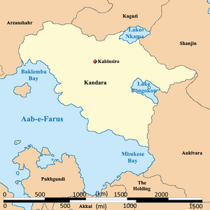
'''Kandara''', officially the '''Sovereign and Independent People's Republic of Kandara''', is categorized as a {{wp|Least developed countries|least developed country}} nation in central [[Audonia]]. It is bound by the [[Aab-e-Farus]] in the east, [[Jazee]] in the northwest, [[Kagazi]] in the north, and [[ | '''Kandara''', officially the '''Sovereign and Independent People's Republic of Kandara''', is categorized as a {{wp|Least developed countries|least developed country}} nation in central [[Audonia]]. It is bound by the [[Aab-e-Farus]] in the east, [[Jazee]] in the northwest, [[Kagazi]] in the north, and [[Ogonkai]] and [[Ankivara]] in the east. It is known as the world's only {{wp|kraterocracy}} run by a violent military regime led by Admiral-General Stephan Mojalefa. | ||
It is a member of the [[League of Nations]], the {{wp|International Red Cross and Red Crescent Movement|International Red Cross and Red Crescent Movement}}, and many other international organizations, but is not an active participant, rather an aide recipient. | It is a member of the [[League of Nations]], the {{wp|International Red Cross and Red Crescent Movement|International Red Cross and Red Crescent Movement}}, and many other international organizations, but is not an active participant, rather an aide recipient. | ||
Revision as of 16:51, 30 December 2024
Sovereign and Independent People's Republic of Kandara Kandhera | |
|---|---|
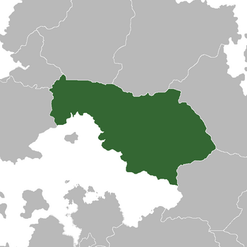 Location of Kandara (dark green) In Audonia (gray) | |
| Capital | Kabinsiro |
| Largest city | Port of Bomonba |
| Official languages | Kandaro, Burgoignesc language |
| Ethnic groups | Primarily Kandi |
| Religion | Shia Islam, or Mercantile Reform Protestantism in a 60/40 split |
| Demonym(s) | Kandari (noun) Kandaran (adjective) |
| Government | Kraterocracy |
• Admiral-General | Stephan Mojalefa |
| Establishment | |
| 1795 | |
| Area | |
• | 1,515,583.34 km2 (585,170.00 sq mi) |
| Population | |
• Estimate | 18,476,480 |
• Density | 12.191/km2 (31.6/sq mi) |
| GDP (nominal) | estimate |
• Total | $32,389,269,440 |
• Per capita | $1,753 |
| Currency | Common Middle Sea Florin (CMS ƒ) |
Kandara, officially the Sovereign and Independent People's Republic of Kandara, is categorized as a least developed country nation in central Audonia. It is bound by the Aab-e-Farus in the east, Jazee in the northwest, Kagazi in the north, and Ogonkai and Ankivara in the east. It is known as the world's only kraterocracy run by a violent military regime led by Admiral-General Stephan Mojalefa.
It is a member of the League of Nations, the International Red Cross and Red Crescent Movement, and many other international organizations, but is not an active participant, rather an aide recipient.
It is a command economy focused on raw resource extraction and export, under the watchful eye of Burgundie whose companies have a massive stake in the country's economic activity. Despite its status as a failed state, it is an active member in the Middle seas region's economic activity due primarily to the sheer size of its mineral wealth.
Many scholars have criticized its economic governance and politics, arguing that it is merely a client of the Burgoignesc thalattocracy's economic and cultural might.
The people of Kandara are predominantly culturally Kandi, speak Kandaro, and most practice Shia Islam, or Mercantile Reform Protestantism in a 60/40 split.
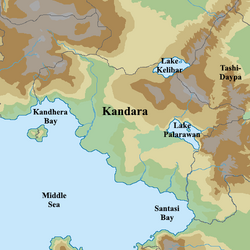
Geography
-
Kandaran coast
-
Kandaran coastal plain
-
Farming in the interior
-
Kandaran highlands
-
Fishing village
-
"The Scrub" of the coastal plains
Climate
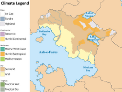
Because of its location, at the eastern end of the tradewinds, Kandara is exceptionally arid. Any moisture from the interior plains of the Dolong region of Audonia catching in the Kinkasendjo mountains before it reaches the Kandara coastal plains.
History
Prehistory
It's estimated that the first settlements of pygmies in present-day Kandara were settled around 12,000 BCE. These settlements were primarily in the interior of the Arumami River Plains. Some 5,000 years ago, the area was not so semi-arid and the vegetation might have been closer to a savanna woodland. However, desertification set in around 2500 BCE, and the desert became much like it is today. This desertification pushed the pygmy people into the mountain regions by 2000 BCE. The interior had become mostly uninhabited by 1500 BCE, and the mountains had become the primary areas of both settlement and cultivation of crops. There were still bands of pygmy nomads in the desert coastal plain but not nearly to the same extent that there had been two or 3,000 years prior. Coastal settlements became more and more settled as the cultivation of grains and the raising of goats and sheep in small semi-arid pockets became more sustainable for the larger populations around 40 BCE, by non-pygmy Kana people.
Classical Antiquity
In the southern part of the present-day Kandara the expansion of the Arunid Empire, starting in 183 BCE, through 832 CE, spread the concepts of monotheism to the Kana people. The trade routes of the empire made the small settlements larger and the meager salt cultivation that the Kana engaged in became a critical resource of the Arunid Empire, and the Kana population boomed. In the northern mountainous regions the tribes who have left the coasts began to create unique cultures and customs that would become the ethnic groups that make up Kandara today. They mined precious gems and gold that they traded with the Arunid Kanans but the harshness of the desert made it impossible for the empire to expand further. As the Arunid Empire was conquered by the Oduniyyad Caliphate throughout the 800s, their influence in the lands of the Kana waned until, in 832 it seems to have disappeared altogether. For 100 years the Kana ruled themselves and built a salt trading empire that would become their downfall and bring the Oduniyyad Caliphate to their doorstep.
Oduniyyad Caliphate
The Oduniyyad Caliphate ruled most of present-day Kandara from 931 - 1383, calling the provinces the Sudanieen (Arabic for "of the black people"). They were brutal in their rule, enforcing strict Sharia law and demonizing and belittling the Kanans. They enslaved most of the population and forced them to work the salt mines or sold them to other powers in Audonia as part of the Oduniyyad chattel network.
Medieval period
Khandharan Caliphate and the Queendom of Santasi
Even before the fall of the Oduniyyad Caliphate after the Shia and Sunni ideological split in Islam, the foundations of the Khandharan Caliphate were laid as it became the theological and cultural capital of the Shia aspects of the Oduniyyad Caliphate. When the Oduniyyad Caliphate did eventually fall the Khandharan Caliphate immediately picked up the pieces of the Empire and maintained them in the northeast. It did lose some provinces in the far north and in the interior some to the Myanga Ayil Khanate and others to what would become the Queendom of Santasi. Santasi was strong in rural areas that had not been under the direct control of the Oduniyyad Caliphate and had maintained a strong sense it's of its native culture and heritage. Free of the restrictions of Islam, the Santasi re-normalized shamanism and ritual cannabalism. Therefore, Santasi eventually became an ethnic Siphosti-state where anyone who opposed the Khandharan Caliphate, and Islam in general, could go to practice their traditional animist religion or also to join the army in opposition to the Khandharan Caliphate.
These two nations occupied the western interior and coastal parts of modern Kandara. The Khandharan Caliphate remained connected to the Pre-modern global trade networks but the Queendom of Santasi did not and focused more on sustenance farming, herding, and some fishing. The Khandharan Caliphate conducted slaving raids into Santasi territory and sold the slaves onward, but also maintained and secured the Silk Road for tolls which were the primary large-scale economic drivers of the state. While both states were sovereign in their own right, neither was particularly centralized, powerful, or militarily capable, so when Occidental colonists showed up in the 16th century they were not prepared.
Myanga Ayil Khanate
The eastern highlands of Kandara were conquered and ruled by the Myanga Ayil Khanate from 1385-1631 after which point the Cote d'Or colonial forces captured the area and pushed out the Khanate. The conquered region was the western most edge of the Khanate's realm in that time period and it prospered during the nearly 250 years it was under Khanate control. It became an important part of the Pre-modern global trade network serving as the interface between Dolong and the Aab-e-Farus which, in turn, connected Dolong to the Sea of Istroya trade network. By securing the Ubakuru River connecting Lakes Nkama and Bongkou, the Khanate created a new north-south trade route which became vital to the expansion of the Silk Road, the Incense Route, and the Spice Trade. The region's tribes were organized under war chiefs who pledged fealty to the Khans and extracted tolls and protected trade routes in exchange for a portion of the revenues. The war chiefs were also paid to suppressed rebellious tribes through land grants, slaves, and horses from the Dolong interior. These chiefs became incredibly wealthy and often had retinues of over 10,000 soldiers. However, corruption became rampant, and the retinues became less militarily focused and more intent on political wrangling. By the time of the arrival of the Bergendii in the early 1600s, the chiefs were easily persuaded away from the Khanate with the promise of more land, greater riches, and more slaves. However, after the retinues failed to live up to expectations, the Bergendii used them as cannon fodder in their campaigns against the Khanate, killed underperforming troops for even the most minor offenses, and disbanded many more. What had once been a feared force of almost 64,000 warriors of the combined retinues, by 1668, in the Battle of Telmen-Uul was merely 5,000 haggard troops of ill-reputation.
Early modern history
Cote d'Or colony
The Burgoignesc colonization of Kandara, spanning from 1598-1795, began with the arrival of Kiravian explorers in the late 15th century, drawn by rumors of gold. The subsequent entry of the Duchy of Marialanus' South Sea Expedition Company (SSETC) in 1598 marked the official start of colonization. Initially, the SSETC adopted a more open approach, re-empowering local magistrates with ties to the former Oduniyyad Caliphate to gain access and trade advantages. This period (1598-1635) saw limited self-sufficiency in the colony, with heavy reliance on the Marialanii metropole. As the generation of Oduniyyad-appointed magistrates aged out, the SSETC tightened their grip (1635-1693). Power shifted towards direct control of politics, land management, and resource extraction. The patroonship system emerged, granting powerful individuals semi-autonomous control over vast latifundia plantations in exchange for loyalty and resource extraction. Chattel slavery became central to the colonial economy, primarily targeting populations outside Cote d'Or colony's major polities. A massive influx of Levantine Protestants, promised land grants, led to rapid coastal expansion and further displacement of native populations. Local militias, primarily composed of native levies, served as the initial line of defense against resistance on the expanding frontiers. By the late 17th century (1693-1785), the SSETC consolidated power further, establishing centralized administrations and presidencies for efficient control, abolishing the natively run protectorates. Demographic shifts due to immigration and slavery resulted in some colonies achieving majority Bergedii and Deric populations, creating internal tensions. Colonial militias were gradually replaced by professional regiments directly controlled by the SSETC, incorporating subjugated native peoples. Utilizing these well-equipped forces, the SSETC embarked on aggressive territorial expansion, drastically enlarging the colonial borders. However, the seeds of decline were sown during this period (1785-1795). The SSETC became increasingly corrupt and focused on prestige, neglecting efficient administration and development. The vast size and mismanagement of the Cote d'Or colony proved unsustainable, leading to discontent and separatist movements. High taxes and tariffs on both settlers and native populations fueled resentment, while insensitive leadership and disregard for native customs sparked widespread mutinies within native regiments. The Great Rebellion of Slavery Bay ignited a domino effect, leading to uprisings across major colonies, a mass exodus of Occidental settlers, and plunging the colonies into chaos. Poor leadership and internal conflicts within both the colonies and the Marialanii metropole ultimately resulted in the loss of Cote d'Or colony. The legacy of Burgoignesc colonization remains deeply embedded in contemporary Kandara. While resistance left its mark, lingering influences of Burgoignesc language, religion (Mercantile Reform Protestantism), and architecture are still discernible. The extractive colonial economy left Kandara with depleted resources and underdeveloped infrastructure, contributing to its current status as a least developed country. Perhaps most significantly, the fractured tribal landscape exploited by the Bergendii continues to influence Kandara's political complexities and internal divisions, shaping the nation's ongoing, violent pursuit of unity and development.
Colonial administration
In Cote d'Or, power flowed downwards from the Duke of Marialanus, through the appointed Governor-General and the ever-watchful South Sea Expedition Company (SSETC). At the heart of the system lay the patroons, powerful individuals granted vast Latifundia in exchange for loyalty, resource extraction, and settlement development. These semi-autonomous lords held sway over their domains, levying taxes, administering justice, and commanding local militias. Tenant farmers and non-patroon settlers, primarily Deric and Bergendii protestant immigrants, possessed a limited voice through a Colonial Council. This body, however, held little real power, serving more as an advisory board than a true decision-making body. The Kandari people, meanwhile, were excluded entirely from formal power structures, governed only by their own traditions and facing limited opportunities within the colonial hierarchy. This system, initially designed for efficiency, shifted towards authoritarianism as challenges arose. Mounting resistance, internal corruption, and economic pressures led to stricter controls, increased military presence, and marginalization of both the Kandari and the Colonial Council. Local militias were replaced by professional regiments controlled by the Governor-General, tightening the grip of the central administration. Cote d'Or's administration thus reflected a stark hierarchy, with wealth and influence concentrated in the hands of the colonial elite. While non-patroon settlers held a semblance of participation, the Kandari people remained disenfranchised, foreshadowing the tensions and conflicts that would mark the colony's future.
The colonial administrators were master negotiators and strategists and were always looking for ways to expand their colonial boundaries. They used the TerreRaubeuers to masterful effect and generally kept the colonists engaged in Colonial militarism and proselytization. They also knew and worked to keept he tribes divded and at war with eachother. They were also adept at using the Doctrine of Lapse.
Colonial economy
The bustling economy of Cote d'Or showed the tenacity, resourcefulness, and ambition of its Bergendii and Deric colonists. They set about building roads and ports as soon as they arrived and connecting their emporia to the existing Silk Road with haste. The initial and staple commodity that led to the colonization of the area was salt. The patroon system allowed them to establish latifundia immediately which soon boasted towering date palms, yielding sweet fruits and sap, which was exported as a delicacy and sweetener. As the colony expanded into the semiarid interior, massive cattle and cotton latifundia were established, which was fed into the existing textile industry in Kandara. Bergendii and Kandari weavers became renowned for their skill, crafted fine cloth coveted across Levantia and Sarpedon. As they spread further into the foothills, the humid highlands was harnessed to industrialized the cultivation of cardamom, ginger, turmeric, and, in select highland pockets, tea plantations. Nestled amidst the secrecy of the highlands, poppy fields bloomed, yielding raw opium, a highly profitable commodity that was used in Kandara as well as other colonies when the population was unruly.
Late modern period
Post-colonial 19th century
After Burgundie had been pushed out of the Cote d'Or colony, the Kingdom of Santasi was reformed and controlled much of the coastal parts of modern-day Kandara. They spent the first 20 years working to consolidate their power and expand along the coast. A loose coalition of tribes in the interior and northern parts of the country more or less focused internally on their own realms but would if threatened by external forces, as they were by the Kingdom of Santasi in the 1840s, be able to band together against the common enemy and push them back out. By the 1860s many of these tribes had more or less fallen under the sway of Emir ibn Oua K'nda who eventually would create a unified state in 1871 called the Second Kandaran Caliphate. The Caliphate lasted until 1922 after which, through internal struggles, it fell to a more unified Kingdom of Kandara as it was called when combined with the Kingdom of Santasi. During this time life for the inhabitants of modern-day Kandara was mostly focused on small-scale sustenance farming and herding, with some communities along the coast being able to conduct trade across the iMiddle seas region. There were no major exports of note during this period as there were no larger-scale mechanisms to ensure that there was enough supply to make it financially viable to export any particular commodity.
First Great War
The first Great War had very little actual impact in Kandara itself however it did shift some of the power in Audonia in general away from some of the more traditional partners and enabled more external interventionism outside of the existing relationships on the continent which gave rise to new ideologies like communism. While none of this occurred in Kandara directly it would eventually have a much larger impact later in the 20th century, on the trajectory of the country.
Contemporary period
Second Great War and it's aftermath
During the second Great War Kandara came out against the occidental forces in the area including the local military base still maintained from the colonial era in rodania by Burgundy. A series of massacres of Rhodainia whites led to direct intervention by Burgundy. These interventions initially just maintaining a coastal blockade and destruction of and holding of the major port cities by the begoniasque military eventually led into a series of campaigns into the interior to try to relieve the Rhodainia Planters' Rifle Corps. These campaigns conducted in 1938, 1939, and the beginning of 1941 were all more or less successful for the kandarins preventing the burgundyesque forces from reaching Rhodainia however, in 1941 the burgundy has forces were successful after they had reevaluated their strategy in desert campaign warfare and adopted the AMP 38 from arcia. Their new lightning strike techniques and thunder running was able to break through a series of kandarin defense lines and reach Rhodainia. From late 1941 until the end of the war in 1943, burgundy was
Communist coup and Operation Kipling
Government and politics
The core of the Kandaran Kraterocracy lies with its warlords. These individuals, typically hailing from prominent Kandaran families or having risen through the ranks of the military, command heavily armed militias. The size and influence of a warlord is directly tied to the strength of their militia. Through force of arms, they control territory, extract resources, and levy taxes on the populace within their domain. Their loyalty to the central government, often referred to as the High Council, is tenuous at best, often shifting based on perceived advantage or immediate threats.
The High Council is situated in the capital of Kabinsiro and is composed of representatives from each warlord. The Council serves as a forum for negotiation, dispute resolution, and the establishment of internal truces. Agreements are reached through a combination of persuasion, veiled threats, and occasional bursts of open hostility. The Council's power is limited, relying heavily on the cooperation of individual warlords. They can attempt to broker deals, facilitate trade agreements, and even levy a nominal national tax, but enforcement relies on the will and whim of each warlord.
Despite the decentralized nature of power, Kandara does possess a few key institutions that exert a degree of influence.
Office of the Admiral-General: Currently held by Stephan Mojalefa, the Office of the Admiral-General is the highest position in the country and presides over all of the national affairs of the state. The Admiral-General is the head of state and the head of government, such as it is, in Kandara. There are no elections for the position, it is taken and held by force by a warlord. Stephan Mojalefa is the warlord from Cote d'Or district.
The Army National of Kandara (ANK): A relatively small and poorly equipped force, the ANK serves as the official national army. Composed primarily of conscripts, the ANK's primary role is to defend the nation from external threats. However, its effectiveness is hampered by limited resources, outdated equipment, and occasional loyalty conflicts, as some warlords view the ANK with suspicion.
The Ministry of Resource Management: This ministry, theoretically responsible for overseeing the exploitation of Kandara's natural resources, holds limited actual power. While it attempts to establish quotas and regulations, enforcement relies on cooperation from warlords who control the actual mining and extraction operations. Corruption within the Ministry further undermines its effectiveness. It's one true influential aspect is brokering deals overseas for exporting Kandarans goods and resources. It also controls the ports which it does relatively well and with a lower level of corruption than most other transactions in the country.
The Kandaran Supreme Court: Located in Kabinsiro, the Supreme Court is intended to be the highest judicial authority in Kandara. However, its reach is limited by the power of the warlords. Judgments are only enforceable within the territory controlled by a cooperative warlord. In areas under strong warlord control, local courts, often influenced by the warlord's will, hold greater sway.
Administrative divisions
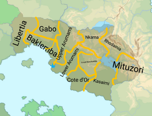
- 1.Rhodainia
- 2.Cote d'Or
- 3.Capital District
- 4.Mituzori
- 5.Baklemba
- 6.Upper Arumami
- 7.Lower Arumami
- 8.Nkama
- 9.Gabo
- 10.Kasaimi
- 11.Great Rwentumba
Military
Army National of Kandara
Traditional state military with traditional weapons and equipment contracts with respected overseas countries, namely Burgundie, Urcea, and Yonderre. Mixed of mechanized and unmechanized forces with some air support. Fully logistically supplied by the state. It has 17,000 full time soldiers and a ready reserve of 68,000. It is divided into the 1st Armored Division (active), 2nd Infantry Division (Reserve), 3rd Infantry Division (Reserve), and the Force Publique (a division level unit that serves as the state gendarmerie). The 1st Armored Division is comprised of the 3rd Regiment Hussars, 1st Regiment of Foot, 9th Regiment of the Line, and the Grand Garrison Artillery Battery. The Force Publique is a 27,000 strong mobile gendarmerie that serves to maintain public order and to patrol the highways.
The Army also maintains an air contingent with a fighter-bomber wing, a transport wing, and a reconnaissance/COIN wing.
Maritime Gendarmerie of Kandara
The Maritime Gendarmerie of Kandara (Burg: Gendarmerie Maritime de Kandara (GMK)) operates 3 frigate divisions each consisting of one frigate and 3 smaller craft, typically patrol boats or missile boats. The country operates one diesel electric submarine, but it is more for show then a combat capable warship. The GMK also operates 6 independent littoral patrol boats for search and rescue, harbor patrol, and drug interdiction.
Warlord forces
Kando Lalrissian's Army of God
Religiously-based militia, numbering around 5,000 soldiers, supported by proxy from large external states using intermediary buyers.
People's Liberation Army of Gabo
Regional socialist independence army for the region of Gabo. There are around 7,000 soldiers almost entirely mechanized in technicals.
General Fully Clothed's Janjaweed
Cult of personality around General Fully Clothed (ne Othiamba Adiwuor). numbering around 450 soldiers, based on the season.
Loko Haram-Bey
Anti-occidental, Burgophobia Islamist militia, numbering around 2,500. Mix of partisan irregular infantry and technical-mounted attack squads
Society
Self-reported ethnic origin in Kandara (2030)
-
A big ole' Kandaran baby
Art
Storytelling is a cornerstone of Kandaran life. Griots, communal storytellers in the same tradition as medieval Occidental bards, preserve the history and myths of their tribes with tales of heroism, folly, marriages, lifes, and deaths of key figures. These stories are not just for entertainment; they are the codification of tradition, passing down knowledge of survival skills, tribal history, and moral codes of the tribes in which they are told. Art too, serves as a powerful medium for cultural expression of the Kandari people. Among the unique art styles of Kandara, sand paintings, depicting scenes of daily life, spiritual beliefs, and historical events are the most internationally recognized and enduring symbol of Kandaran art. Sculptures carved from ebony or weathered stone depicting revered ancestors and mythical creatures that populated the pre-Islamic and pre-Christian Kandaran pantheon, these figures have made a return to the Kandaran art scene in the latter half of the 20th century, especially during and after Operation Kipling when some Burgoignesc and Urcean soldiers brought some of the ancient statues back and they made a splash in those countries art scenes in the late 60s.
Religion
Self-reported religious affiliation in Kandara (2030)
Religion in Kandara is a complex reflection of the nation's violent and colonial history. The majority adhere to Shia Islam, a vestige of the area's domination by the Oduniyyad Caliphate. Mosques, serve as centers not just for prayer, but also for education and social gatherings, especially in the interior. However, a significant minority practices Mercantile Reform Protestantism, a faith introduced by the Burgoignesc colonizers. Simple white clapboard churches, testaments to a bygone era of colonial dominance, stand as stark reminders of a troubled past, and stand in direct contrast to the massive and opulent mosques. While religious tolerance is generally practiced, tensions occasionally flare, particularly in competition for influence within the government or control of resource-rich areas. Almost 6% of the population are members of the Patriarchate of Marand a uniquely Audonian Christian sect. 13.8% practice animism or shamanism, especially in the northern areas where the Queendom of Santasi was strong.
La Sape
Further: La Sape
-
Kabange in 1935, credited with bringing La Sape into the spotlight.
La Sape, an abbreviation based on the phrase "Society of Ambiance-Makers and Elegant People" (Burg: Société des Ambianceurs et des Personnes Élégantes) and hinting to the Burgoignesc slang word sape which means "clothes" or sapé, which means "dressed up". An adherent of La Sape is known as a sapeure or, if female, as a sapix. The movement embodies the elegance in style and manners of colonial predecessor dandies. It is a subculture that is unique to Kandarans and the Kandaran diaspora, although it is related to other fopish styles in that it is a modern offshoot of Burgoignesc dandyism.
Architecture
-
Mid-20th century residential architecture
-
Great Mosque of Ta'kongwe
-
Modern housing style
-
Jumaiya Mosque in Kabinsiro
-
Traditional brich-built home in the interior
-
Occidental-influenced urban architecture
-
Many buildings in Kandara are built of cinderblock construction with a stucco exterior
-
Remnants of the communist regime remain, especially in the universities built during their short reign
Much of the ancient surviving architecture in Kandara is comprised of the Islamic architectural style brought by the Oduniyyad Caliphate. Much of these are religious buildings like mosques and masjid and other are government buildings primarily in the large urban settlements that would become the cities along the coasts. In the early modern period, architectural influences came primarily from the Occidental world, especially the styles in Burgundie. These Levantine styles persisted and even after the collapse of the Burgoignesc colonial empire and a resurgence of Occidental architectural motifs became the norm, especially in the late 20th century, after Operation Kipling. However, in the 1990s until now there has been a revival of more classical building methods, local building materials, architectural motifs reminiscent of both Siphosti and Islamic styles of the past. While most urban cores reflect the more Occidental styles of the late 20th century and early 21st century, other less densely populated areas are much more visually reminiscent of historical Siphosti architectural styles.
Economy
Agriculture, forestry, and fishing

Agriculture, forestry, and fishing are the major employment activities in Kandara and are the largest economic sector in the country. They contribute more than 65% to the national GDP from domestic distribution and exports to other parts of the continent of Audonia. 7.3 million tons of maize; 4.9 million tons of sorghum; 4.2 million tons of wheat; 2.1 million tons of barley; 1.8 million tons of sweet potato; 1.4 million tons of okra; 1.3 million tons of yam; 988 thousand tons of broad bean; 982 thousand tons of millet; 743 thousand tons of potato; 515 thousand tons of chick pea; 508 thousand tons of banana; 470 thousand tons of coffee; 446 thousand tons of cabbage; 374 thousand tons of pea; 322 thousand tons of onion; 301 thousand tons of sesame seed; 294 thousand tons of bell pepper; 172 thousand tons of lentil; 144 thousand tons of rice; 143 thousand tons of peanut; 140 thousand tons of cotton; 124 thousand tons of garlic; 102 thousand tons of mango; (including mangosteen; and guava); and 101 thousand tons of linseed.
Highland agriculture
In the interior Kinkasendjo Mountains, the famed karakul sheep are raised for their wool and the once massive colonial tea plantations have seen some Burgoignesc investment and are therefore seeing a nascent resurgence as an aspect of the economy, particularly on the eastern slopes of the Kinkasendjo Mountains and the northern slopes of the Mituzori Mountains.
TV and Film
Because of its total lack of regulation and the incredibly low cost of labor Kandara's interior desert has been used as the set for many TV shows and films. This has become a particularly valuable revenue source for some of the interior warlords who have enjoyed a strong relationship with the Occidental film industry since the start of the 21st century. Post-apocalyptic films in particular because of their lower budgets on average tend to enjoy filming in Kandara's deserts. The first three films that set this trajectory in motion were "A Youth and his pup" (1973), "Intergalactic Battles" (1977), and "Angry Mat" (1987).
Mining sector
The Kinkasendjo Mountains have the greatest concentration of mineral riches, where mining has been occuring for centuries. Opal, emeralds, and gold are the key mined resources through Kandaran history. But the colonial era cast a long shadow over the Kinkasendjo mountian mining communities. The Burgoignesc, with their steely resolve and insatiable greed, tore into the mountainsides with an early industrial fury. Coal to power the engines of empire, became the new obsession. Entire villages were uprooted, slaves forced into the darkness of the new and massive mines. Today, mines many co-owned by Kandaro-Burgoignesc firms, mine coal, opals, gemstones, kaolin, iron ore, and tantalum in the Kinkasendjo. They employ 120,390 people and are the lifeblood of the communities that have been built up around them. Most cities and towns in the Kinkasendjo are attached to mines or to the rail junctions built in the 40s and 50s to connect the mines to the coast. The largest of these cities and towns are Emeraudeville, Binkara, Kayongo, Wambundu, and Pwetzo.
Diamonds, tantalum, gold, coal, iron ore are mined in the Mituzori Mountains, in the northwest of the country. Because these deposits were not fully reaslized until the 20th century mechanization and open-pit mines are more common in these mines. While undeniably more efficient than the methods of the older shaft mines in the Kinkasendjo Mountains, the Mituzori operations remain a far cry from the sophisticated marvels employed in other parts of the world. Technology, though present, is outdated, its limitations a constant reminder of Kandara's struggle as a least developed country. There are six major company towns built around mines of the same names: Zinkolobwe, Tshimbubwe, Monkbwalu, Masono, Oui K'nda, and Idjwino.
The vast coastal plains hold sprawling salt flats and Kandara's salt industry is as old as civilization itself. Today, industrial salt farms extract almost a million tons of salt each year. The resulting product, while plentiful, is unrefined, lacking the purity demanded by international culinary markets. Much of it is exported for industrial uses or sent to other countries for further processing. A significant portion of the salt is used in the countries massive but very environmental harful soda ash manufacturing industry.
Infrastructure
Air
Kandara's national carrier is KandAireA Airlines. It has two main international airports Kabinsiro International Airport and Cote d'Or International Jetport. These two serve as the primary international travel departures and destinations. Kabinsiro is the primary civilian entrepot for the country, while Cote d'Or International Jetport serves primarily as the receiving airport for high-ranking government and commercial passengers. Cote d'Or was built in 2012 when the current president took office as a way to invest in his own community and region. It was designed to serve private and charter jets and is not large enough for large commercial carrier airframes. Kabinsiro was built in the late 1960s during Operation Kipling as a military transportation hub that began to serve commercial passengers in 1973. It has seen numerous runway expansions, especially in the 1980s, early 2000s, and most recently in 2029. It operates daily flights to major hubs in Audonia and beyond and able to serve all airframe sizes with the exception of some of the largest.
Due to the inequitable division of resources and wealth in the country and a very poor road maintenance program many warlords and government officials have small bush planes that they use to travel between disparate communities. These planes are outfitted with very large tires and so can land on any patch of desert ground.
Rail

Kandara uses Standard gauge, 1,435 mm (4 ft 8+1⁄2 in) as most of its rail infrastructure has been under the auspices of Burgundie and its sphere of influence in the Middle seas region, who all use that rail gauge. Rail is one of the most important pieces of infrastructure and one area where all of the warlords can agree that a unified approach is important. The country has 1.7 million km of standard gauge rail and about 37% of that is double rail. Because of the harsh conditions in the interior desert most of the rail itself is not electrified and so diesel locomotives do the majority of the work. However along the coast in between the major cities there has been some effort in the 21st century to electrify the rail corridors by 2030 there are approximately 2,500 km of electrified rail on the western seaboard. In the upper mountains because of the heavy loads pulled by the rail cars again diesels are the primary mode of power generation because it was determined that the amount of power needed in an overhead electrified system would not be feasible with the ability of the countries to maintain the infrastructure.
Rail is also a primary mode of transportation for passengers as well with 60% of all rail being passenger and freight rail capable major transportation hubs between the cities and the mining towns in the interior see the most traffic with approximately 2.7 million trips a year booked through these services.
Roads

Car ownership in Kandara is exceedingly rare with only the most elite government officials and corporate magnates owning cars. They typically own entire convoys of cars due to the volatile nature of inter-provincial travel under heavily armed guard. Because of this road infrastructure is not highly prioritized in the country with the exception of for commercial and industrial uses. The majority of Kandara's roads are unpaved and many of them are just traditional tracks throughout the arid landscape. In the 1940s and '50s many main arteries were created and paved between oasises and communities across the desert and along some of the major river basins. However due to the extreme environment and current government system many of these roads have fallen into extreme disrepair or been completely comfort over by sands and no longer formally exist. However along the coastline there are two major arteries the first called Government highway 1 and the second is trunk road 985 which connects the major port cities and hubs along the coast these two roads run primarily in parallel about 50 km apart from each other one of them being reserved for truck traffic and the other being a military road that is used in peacetime by civilian and commercial traffic. Because of the importance of the mining communities in the mountain areas, the mountain roads are typically better maintained due to foreign investment. These roads are typically paved with good drainage but are used primarily for commercial and industrial truck traffic. There are some civilian roads that can be used by commuters but they are often tolled and due to corruption usage can be fairly low because tolls can be exorbitant.
Louage

A louage is a minibus shared taxi in many parts of Daria that were colonized by Burgundie. In Burgoignesc, the name means "rental." Departing only when filled with passengers not at specific times, they can be hired at stations. Louage ply set routes, and fares are set by the government. In contrast to other share taxis in Audonia, louage are sparsely decorated. Louages use a color-coding system to show customers what type of transport they provide and the destination of the vehicle. Louages with red lettering travel from one state to another, blue travel from city to city within a state, and yellow serves rural locales. Fares are purchased from ticket agents who walk throughout the louage stations or stands. Typical vehicles include: the MILCAR Jornalero, the TerreRaubeuer Valliant 130, and the CTC M237-07.
See also


