Port de Vent
This article is a work-in-progress because it is incomplete and pending further input from an author. Note: The contents of this article are not considered canonical and may be inaccurate. Please comment on this article's talk page to share your input, comments and questions. |
Trade Islands of Port de Vent | |
|---|---|
 Flag | |
 Map of Port de Vent | |
| Nation | |
| Constituent Country equivalent | Burgoignesc Overseas Representative Assembly |
| Geographic Designation | Polar Burgundies |
| Capital | Ville Port de Vent |
| Area | |
| • Total | 62,366.9137 km2 (24,080.0000 sq mi) |
| Population (2030) | |
| • Total | 11,302,230 |
| • Density | 180/km2 (470/sq mi) |
| Demonym(s) | Ventoise |
Port de Vent is an trade island province of Burgundie in the Kindreds Sea's Catenias archipelago, consisting of five major islands or island groups: Gicupiccu, Ile Melite, l'Ile Osilies, and l'Iles Capræs.
History
The islands of the Catenias archipelago have long been a cultural cross roads.
Prehistory
Archeological evidence suggests that humans first settled permanently on the islands of modern Port de Vent and the Krasoa Islands around 4200 BCE. The Sundaic, Alitros sea people of the Glaistic civilization, established their first settlements along the coast, carving rudimentary dwellings into the cliffs. Their lives revolved around fishing, hunting, and navigating the treacherous currents of the archipelago's straits.
However, around 1100 BCE, Sundaic legends speak of encountering the Sky People, beings of immense stature who arrived in colossal vessels and possessed advanced knowledge, likely Adonerii. The Sundaic, initially wary, eventually formed a tentative connection. The Sky People shared some of their knowledge, influencing the island's intricate water channels and the unique architectural style of some Sundaic structures, incorporating the Latinic architecture into Glaistic megaliths. The islands that make up Port de Vent and the Krasoa Islands became the southwestern extent of the Adonerum and therefore remained a peripheral place meaning that no great effort was put into contralizing or enculutrating that Sundaics. Evidence suggests that Glaistic masks, with their enigmatic smiles and intricate details, may have been adopted into the Adonerii religious and social rituals, later evolving into symbols of power and leadership. Around 600 BCE, Adonerii legends speak of a devastating tsunami that impacted the Catenias archipelago. The Sundaic outposts across the region, including those on Port de Vent, were abandoned or destroyed. The Sundaics vanished from the historical record, but DNA evidence shows a pattern of intertribal breeding that pre-supposes that the Sundaics didn't disappear as much as they ceased to be unique and were more than likely just merged into the existing Adonerii identity. After the disaster, competition for limited resources, competition for fertile land, and fishing grounds grew between different Adonerii city-states, led to the rise of despotates vying for dominance. 600-200 BCE was marked by terrible inter-city violence, and slavery and piracy emerged as key aspects of southwestern Catenias Adonerii power structures and society.
Antiquity
Antiquity in Port de Vent covers from the time of the Great Tsunami around 607 BCE through the 4th century CE and was marked by an increasingly centralizing series of Latinic-states in the Catenias archipelago. The northern islands of Port de Vent (Gicupiccu, Ile Melite, and Ile Gran Osilie) were conquered and ruled by the Emerita Maris (modern-day Lucrecia), starting around 250 BCE. The city states on the remaining islands Ile Picu Osilie and l'Iles Capræs remained independent throughout the period and controlled the trade in the straits that they were beside. The Latinic-states in the southern Catenias archipelago collected a duty on their cargo, typically at 2% or higher. By the end of the 4th century CE, the tax was being collected in Aes grave, an early Latinic crrency. The growth of trade in southern Kindreds Sea and the straits of the Catenias archipelago led to the development of more advanced financial techniques. Most merchants, lacking sufficient cash assets, resorted to borrowing to finance all or part of their expeditions. A typical loan for a large venture in 4th century BC, was generally a large sum of cash, lent for a short time (the length of the voyage, a matter of several weeks or months), at a high rate of interest (often 12% but reaching levels as high as 100%). The terms of the contract were always laid out in writing, differing from loans between friends. The lender bore all the risks of the journey, in exchange for which the borrower committed his cargo and his entire fleet, which were precautionarily seized upon their arrival at the port the loan was offered. This also led to high levels of piracy, which in turn led to the creation and professionalization of anti-piracy/naval forces in the southern Catenias archipelago. Due to the close quarters nature of most of the trade in the area, the smaller Liburna was the primary ships used by the city states and pirates alike in the southern Catenias. As was common in the Ancient world, ramming and boarding were the primary modes of maritime combat for state actors and pirates alike.
The economy and trade was driven by ship building with the endemic coral reef araucaria trees used to build ships and the prosperous nickel mines on the islands which led to a demand for labor which was gotten through both settlers from neighboring lands and from slavery. Slaving raids against Emerita Maris, the Vallejarian kingdoms of Kuckter, Celestria, and Sumania, Maristella, and the Pelaxian islands.
Early modern period
.jpg)
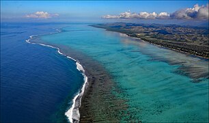
Geography

-

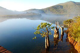
coral reef araucaria trees on the water's edge
-

-

-
-

-

-

-
-

-

-

Kagu

.jpg)
.jpg)


_-_rameau.jpg)
.jpeg)


Flora
The islands of Port de Vent hosts a remarkable assemblage of flora. Towering coral reef araucaria (Araucariaceae) dominate the rainforests. Unique species like the fragrant Gaultheria fragrantissima and the medicinally valuable Tamanu (Calophyllum inophyllum) thriving in the dappled shade. The forest floor presents a diverse tapestry of ferns and flowering plants. Tree ferns (Cyatheaceae) lend a prehistoric charm, while epiphytic orchids (Orchidaceae) adorn the branches with vibrant displays in hues of purple, pink, and yellow. The translucent Ghost Orchid (Epipogium aphyllum) exemplifies the island's remarkable adaptations. Bromeliads (Bromeliaceae) with spiky leaves and colorful flowers add further vibrancy to the understory. Notably, Port de Vent harbors a distinct coffee plant (Coffea ventenensis), its beans prized for their unique aroma. The island's coastal fringe features mangrove forests (Rhizophoraceae) vital for marine life, while salt-tolerant plants like Sea Lettuce (Ulva lactuca) and the vibrant Beach Hibiscus (Hibiscus tiliaceus) thrive in harsher conditions.
Fauna
Port de Vent's fauna exhibits a fascinating interplay of isolation and adaptation. The island's avifauna includes the flightless Kagu (Rhynochetos jubatus), Ventoise Crow (Corvus moneduloides), remarkable and well-researched for its intelligence and tool-using prowess, the Horned Parakeet (Eutrichoglossus carteri) and the Ventenga (Cyanoramphus cookii). The formidable Giant Geckos (Rhacodactylus leachianus) is the provincial animal, some exceeding a meter in length, while Skinks (Scincidae) of various shapes and sizes scamper through the undergrowth. The amphibian fauna remains understudied, but intriguing recent discoveries like the fluorescent tree frog (Hyla ventenensis) with its bioluminescent properties are the focus of an expanding univeristy system that increasingly focuses on further studying the fauna of the islands.
Climate and environment

Port de Vent has a tropical wet climate in the windward (eastern) areas of the islands, a tropical dry climate on the leeward side if the higher elevations, those elevations being a Mediterranean climate.
Economy
Standard of living
Employment
Agriculture
Yams, sweet potatoes, taro, cassava, Chinese cabbage, green onions, Kanak cabbage, mangoes, pineapples, and bananas,
livestock: cows, pigs, and chickens
Agrinergie
Main article: Agrivoltaics

Tourism and hospitality

.jpeg)
Resorts
Cruises
Recreation
Key tourism and hospitality companies
Logging/Mineral extraction
Paper milling
Mining
magnesium, iron, cobalt, chromium and manganese
Drilling
Fishing
Fishing and fisheries
Distant-water fishing fleet
Local commercial fishing
Aquaculture
Main article: Aquaculture Aquatic life farming, in general
- Pisciculture- fish farming
- Mariculture- Saltwater fish farming
- shrimp farming
- oyster farming
- algaculture
Artisanal/heritage industries
Science and research
Finance
Manufacturing
Industrial recycling
Creative industries
Sports and leisure
Trade
| Port Nova Martillia | |
|---|---|
 | |
| Location | |
| Country | |
| Details | |
| Opened | 1949 |
| Employees | 550 |
| Statistics | |
| Vessel arrivals | 179 |
| Annual cargo tonnage | 805.219 tonnes |
| Annual revenue | ₮25 million |
Transshipment
Main article: Transshipment
Customs and tariffs
Main article: Customs
.JPG)
.JPG)


